- History of Oregon
-
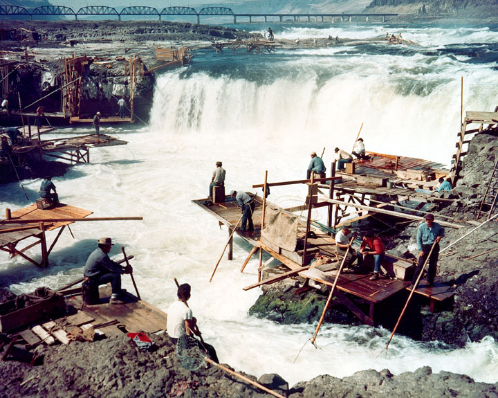
 The construction of dams, like The Dalles Dam, would flood rapids like Celilo Falls. The competing cultural and economic interests of Native Americans and European settlers from various countries have played a prominent role in Oregon's history.
The history of Oregon, a U.S. state, may be considered in five eras: geologic history, inhabitation by native peoples, early exploration by Europeans (primarily fur traders), settlement by pioneers, and modern development.
The term "Oregon" may refer to any of three phases: Oregon Country, a large region explored by Americans, British, and others (and generally known to Canadians as the Columbia District); the Oregon Territory, established by the United States two years after its sovereignty over the region was established by the Oregon Treaty, and before states were established in the Pacific Northwest; and the modern U.S. state of Oregon. (It was also an early name for the Columbia River.)
Contents
Geology
Main article: Geology of the Pacific Northwest
Volcanic activity in the region has been traced to 40 million years ago, in the Eocene era, forming much of the region's landscape. In the Pleistocene era (the last ice age, two million to 700,000 years ago), the Columbia River broke through Cascade Range, forming the Columbia River Gorge.[1]
The Columbia River and its drainage basin experienced some of the world’s greatest known floods toward the end of the last ice age. The periodic rupturing of ice dams at Glacial Lake Missoula resulted in discharge rates ten times the combined flow of all the rivers of the world, as many as forty times over a thousand-year period.[2]
Water levels during the Missoula Floods have been estimated at 1,250 feet (381 m) at the Wallula Gap (in present-day Washington), 830 feet (253 m) at Bonneville Dam, and 400 feet (122 m) over current day Portland, Oregon.[3] The floods' periodic inundation of the lower Columbia River Plateau deposited rich lake sediments, establishing the fertility that supports extensive agriculture in the modern era. They also formed many unusual geological features, such as the channeled scablands of eastern Washington.
Mount Mazama, once the tallest mountain in the region at 11,000 feet, had a massive volcanic eruption approximately 5677 B.C.[4][5] The eruption, estimated to have been 42 times more powerful than the 1980 eruption of Mount St. Helens, reduced Mazama's approximate 11,000 foot (c.3,350 m) height by around half a mile (about 1 km) when much of the volcano fell into the volcano's partially emptied neck and magma chamber. Mazama's collapsed caldera, in today's southern Oregon, contains Crater Lake, and the entire mountain is located in Crater Lake National Park (Oregon's only such park).
The Klamath Native Americans of the area thought that the mountain was inhabited by Llao, their god of the underworld. After the mountain destroyed itself the Klamaths recounted the events as a great battle between Llao and his rival Skell, their sky god.
The 1700 Cascadia earthquake resulted from a rupture in the Juan de Fuca Plate along the coast of the Pacific Northwest.[6] The earthquake caused a tsunami that was detected in Japan;[7] it may also be linked to the Bonneville Slide, in which a large part of Washington's Table Mountain collapsed into the Columbia River Gorge, damming the river and forming the Bridge of the Gods, a land bridge remembered in the oral history of local Native Americans.[8]
In 1980, Mount St. Helens in neighboring Washington erupted violently, temporarily reducing the Columbia River's depth to as little as 13 feet, and disrupting Portland's economy. The eruption deposited ash as far into Oregon as Bend.[9]
Native peoples
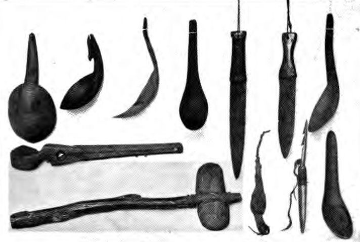
 Tool artifacts of Native Americans in Oregon
Although there is considerable evidence that humans lived in the Pacific Northwest 15,000 years ago, the first record of human activity in present day Oregon came from archaeologist Luther Cressman's 1938 discovery of sage bark sandals near Fort Rock Cave that places human habitation in Oregon as early as 13,200 years ago.[10] By 8000 B.C. there were settlements across the state, with the majority concentrated along the lower Columbia River, in the western valleys, and around coastal estuaries.
By the 16th century, Oregon was home to many Native American groups, including the Bannock, Chasta, Chinook, Kalapuya, Klamath, Molalla, Nez Perce, Takelma, and Umpqua.[11][12][13][14]
Celilo Falls, a series of rapids on the Columbia River just upstream of present-day The Dalles, Oregon, was a fishing site for natives for several millennia. Native people traveled to Celilo Village from all over the Pacific Northwest and beyond to trade. The rapids were submerged in 1957 with the construction of The Dalles Dam.
Early European exploration
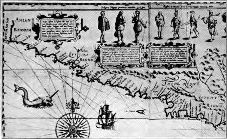
 1601 AD map showing unexplored Oregon Coast
Spanish explorers found a way to explore the Pacific coast as early as 1565, sending vessels northeast from the Philippines, riding the Kuroshio Current in a sweeping circular route across the northern part of the Pacific. These ships – 250 in as many years – would typically not land before reaching Cape Mendocino in California, but some landed or wrecked in what is now Oregon. Nehalem Indian tales recount strangers and the discovery of items like chunks of beeswax and a lidded silver vase, likely connected to the 1707 wreck of the San Francisco Xavier.[15]
Juan Pérez explored the coast of the Pacific Northwest north to British Columbia in 1774. He was the first European to see Yaquina Head on the Oregon Coast.[16] In 1775 another Spanish expedition, under Juan Francisco de la Bodega y Quadra and Bruno de Heceta, explored the coast. While returning south Heceta found the mouth of the Columbia River, but was unable to enter.[17]
James Cook explored the Oregon Coast in 1778 in search of the Northwest Passage. Beginning in the late 1780s many ships from Britain, American, and other countries sailed to the Pacific Northwest to engage in the region's emerging Maritime Fur Trade business. American sea captain Robert Gray entered the Columbia in 1792, and was soon followed by a ship under the command of George Vancouver, a British captain, who also explored Puget Sound and claimed it for Britain.
The Lewis and Clark Expedition traveled through the region during their expedition to explore the Louisiana Purchase. They built their winter fort at Fort Clatsop, near the mouth of the Columbia. Exploration by Lewis and Clark (1805–1806) and the United Kingdom's David Thompson, who extensively explored the Columbia River from 1807–1811, publicized the abundance of fur-bearing animals in the area.
Following the Anglo American Treaty of 1818, the region was "jointly occupied" by the U.S.A. and Britain. The Americans referred to the region as Oregon Country, while the British knew it as the Hudson's Bay Company's Columbia District, which was administered from Fort Vancouver near present day Vancouver, Washington. Joint occupation ended with the signing of the Oregon Treaty in 1846, when Britain ceded all claims to lands south of the 49th parallel.
Native peoples generally welcomed the arrival of Europeans, for the increased trading opportunities; however, the introduction of foreign diseases would prove devastating to local populations.[18] Later, American initiatives to capture the natural resources of the west, perhaps most notably along the Columbia River, would collide with the interests of natives; many tribes accepted multi-million dollar settlements from the U.S. government in exchange for giving up traditional fishing sites, moving to reservations that were often far from their homes.
In recent times, the establishment of casinos has provided some income to tribes that are generally impoverished. Throughout the governorship of Ted Kulongoski, the Warm Springs Indians have negotiated for the right to build an off-reservation casino in the Columbia River Gorge.
Settlement by pioneers
Main article: Oregon pioneer historyThe Astor Expedition of 1810–1812, financed by American businessman John Jacob Astor, brought fur traders to the future site of Astoria by both land and sea.[19] Fort Astoria was the first permanent white settlement in the region. Although the fort would remain under American control for only a short time, it would become a component of the United States' later claim on the region.[citation needed] A party returning east discovered the South Pass through the Rocky Mountains, which would become an important feature of the Oregon Trail.
 Map of the Oregon Country, with most heavily disputed area highlighted. The 1846 Oregon Treaty designated this area for the United States.
At risk of being captured by the British during the War of 1812, Fort Astoria and all other Pacific Fur Company assets in the Oregon Country were sold to the Montreal-based North West Company in October 1813.[20] The North West Company had already been expanding into the Pacific Northwest and dominated the region unchallenged from the 1813 acquisition of the Pacific Fur Company until 1821, when it was absorbed into the Hudson's Bay Company. During this time the North West Company put the Astorian scheme into practice, sending supplies by sea to the Columbia River and exporting furs directly to China.[21] The Hudson's Bay Company expanded the system and during the 1820s and 1830s dominated the Pacific Northwest from its Columbia District headquarters at Fort Vancouver (built in 1825 by the District's Chief Factor John McLoughlin across the Columbia from present-day Portland). Although fur depletion and a crash in fur prices undermined the company in the early 1840s, it remained an important presence until the Oregon Treaty of 1846.
In the 1830s, several parties of Americans traveled to Oregon, further establishing the Oregon Trail. Many of these emigrants were missionaries seeking to convert natives to Christianity. Jason Lee was the first, traveling in Nathaniel Jarvis Wyeth's party in 1833 and establishing the Oregon Mission in the Willamette Valley; the Whitmans and Spaldings arrived in 1847, establishing the Whitman Mission east of the Cascades. In 1839 the Peoria Party embarked for Oregon from Illinois.
In 1841, wealthy master trapper and entrepreneur Ewing Young died without a will, and there was no system to probate his estate. A probate government was proposed at a meeting after Young's funeral. Doctor Ira Babcock of Jason Lee's Methodist Mission was elected Supreme Judge. Babcock chaired two meetings in 1842 at Champoeg (half way between Lee's mission and Oregon City) to discuss wolves and other animals of contemporary concern. These meetings were precursors to an all-citizen meeting in 1843, which instituted a provisional government headed by an executive committee made up of David Hill, Alanson Beers, and Joseph Gale. This government was the first acting public government of the Oregon Country before American annexation.
The Oregon Trail brought many new settlers to the region, starting in 1842–1843, after the United States agreed to jointly settle the Oregon Country with the United Kingdom. For some time, it seemed the United States and the United Kingdom would go to war for a third time in 75 years (see Oregon boundary dispute), but the border was defined peacefully in 1846 by the Oregon Treaty. The border between the United States and British North America was set at the 49th parallel. The Oregon Territory was officially organized in 1848.
Numerous efforts to find easier overland passage to the Willamette Valley were undertaken beginning in the 1840s. The Barlow Road, Meek Cutoff, and Applegate Trail represented efforts to cross the Cascades in the northern, central, and southern parts of Oregon, respectively. The Barlow Road would become the final leg of the Oregon Trail after its construction in 1846, and the Santiam Wagon Road would cut through the central part of the mountains, succeeding where Meek had failed.
Settlement increased because of the Donation Land Claim Act of 1850, in conjunction with the forced relocation of the native population to Indian reservations. The state was admitted to the Union on February 14, 1859.
Oregon in the Civil War
Main article: Oregon in the American Civil WarAt the outbreak of the American Civil War, regular U.S. troops were withdrawn and sent east. Volunteer cavalry and infantry were recruited in California and sent north to Oregon to keep peace and protect the populace. Oregon also raised the 1st Oregon Cavalry that was activated in 1862 and served until June 1865. During the Civil War, immigrants continued to clash with the Paiute, Shoshone and Bannock tribes in Oregon, Idaho and Nevada until relations degenerated into the bloody 1864 - 1868 Snake War. The 1st Oregon Volunteer Infantry Regiment was formed in 1864 and its last company was mustered out of service in July 1867. Both units were used to guard travel routes and Indian reservations, escort immigrant wagon trains, and protect settlers from Indian raiders. Several infantry detachments also accompanied survey parties and built roads in central and southern Oregon.[22]
Oregon Senator Col. Edward Dickinson Baker was killed leading Union troops at the Battle of Ball's Bluff on October 21, 1861.
Railroads and growth
In the 1880s, the proliferation of railroads assisted in marketing of the state's lumber and wheat, as well as the more rapid growth of its cities. This included the connection of the state to the Eastern United States via links to the transcontinental railroads that allowed for faster movement of goods and people. Immigration to Oregon increased after the connection to the east. Additional transportation improvements included the construction of several locks and canals to ease river navigation.
Also in the 1880s, writer Frances Fuller Victor published both fiction and histories that drew on her extensive research of the history of the region, informed by personal interviews with a number of Oregon pioneers. Her most noted non-fiction, which covered many western states, was written while under contract with Hubert Howe Bancroft's History Company, and at the time was published under his name. Her writing was said to accurately capture the notion of Manifest Destiny in this period of American expansion.
Racial discrimination
Both the Oregon Territory and the State of Oregon have had laws and policies discriminating against people of non-white racial backgrounds. An 1844 territorial statute outlawed slavery but also mandated free slaves to leave the territory.[23] A law adopted by the state in 1862 required all ethnic minorities to pay a $5 annual tax.[23] Interracial marriage was prohibited by law between (approximately) 1861 and 1951.[23]
Modern history
 Engineer Conde McCullough designed many of Oregon's bridges, including the Yaquina Bay Bridge in Newport.
Industrial expansion began in earnest following the construction of the Bonneville Dam in 1933–1937 on the Columbia River. The power, food, and lumber provided by Oregon helped fuel the development of the West, although the periodic fluctuations in the nation's building industry have hurt the state's economy on multiple occasions.
The state has a long history of polarizing conflicts: Native Americans vs. British fur trappers, British vs. settlers from the U.S., ranchers vs. farmers, wealthy growing cities vs. established but poor rural areas, loggers vs. environmentalists, white supremacists vs. anti-racists, social progressivism vs. small-government conservatism, supporters of social spending vs. anti-tax activists, and native Oregonians vs. Californians (or outsiders in general). Oregonians also have a long history of secessionist ideas, with people in various regions and on all sides of the political spectrum attempting to form other states and even other countries. (See State of Jefferson, Cascadia, and Ecotopia.)
In 1902, Oregon approved of a system of direct legislation by the state’s citizens by way of initiative and referendum, known as the Oregon System, and in 1908 also empowered its citizens to recall public officials by ballot initiative. Oregon state ballots often include politically conservative proposals such as anti-gay and pro-religious measures side-by-side with politically liberal issues like drug decriminalization which demonstrates the wide spectrum of political thought in the state.
The historical policies of racial discrimination have had long-term effects on Oregon's population. A 1994 report from an Oregon Supreme Court task force found minorities more likely to be arrested, charged, convicted, incarcerated and on probation than "similarly situated non-minorities."[24] The report does not place blame on individuals, but instead points out the problems of institutional racism. The report recommends multicultural training of the existing justice system personnel and also recommends diversifying the perspectives, backgrounds and demographics of future hires.
See also
- History of the Pacific Northwest
- History of the Western United States
- Territorial evolution of Oregon
- List of Oregon ballot measures
- List of fiction set in Oregon
- List of Oregon judges
- List of Governors of Oregon
- List of people from Oregon
- List of native Oregon plants
- List of Oregon county name etymologies
- List of Oregon State Government Agencies
- List of Registered Historic Places in Oregon
- Capital punishment in Oregon
- History of Portland, Oregon
- Mount Hood Freeway
References
- ^ "The Geologic History of the Columbia River Gorge". USGS. http://vulcan.wr.usgs.gov/Volcanoes/Washington/ColumbiaRiver/geo_history_gorge.html.
- ^ "Glacial Lake Missoula and the Missoula Floods". U.S. Geological Survey. http://vulcan.wr.usgs.gov/Glossary/Glaciers/IceSheets/description_lake_missoula.html. Retrieved 2006-11-19.
- ^ Houck, Michael C.; Cody, M.J. (2000). Wild in the City. Oregon Historical Society. ISBN 0-87595-273-9.
- ^ "Crater Lake". Global Volcanism Program, Smithsonian Institution. http://www.volcano.si.edu/world/volcano.cfm?vnum=1202-16-. Retrieved 2006-12-26.
- ^ Zdanowicz, C. M.; Zielinski, G. A.; Germani, M. S. (1999). "Mount Mazama eruption; calendrical age verified and atmospheric impact assessed". Geology 27 (7): 621–624. doi:10.1130/0091-7613(1999)027<0621:MMECAV>2.3.CO;2. http://geology.geoscienceworld.org/cgi/content/abstract/27/7/621.
- ^ Great Cascadia Earthquake Penrose Conference
- ^ Fault slip and seismic moment of the 1700 Cascadia earthquake inferred from Japanese tsunami descriptions
- ^ Hill, Richard L (May 15, 2002). "Science - Landslide Sleuths". The Oregonian. http://earthquake.usgs.gov/regional/pacnw/paleo/greateq/20020515.html.
- ^ Harris, Stephen L. (1988). Fire Mountains of the West: The Cascade and Mono Lake Volcanoes. Missoula: Mountain Press Publishing Company, Missoula. ISBN 0-87842-220-X
- ^ Robbins, William G. (2005). Oregon: This Storied Land. Oregon Historical Society Press. ISBN 0987595-286-0.
- ^ "Oregon History: Great Basin". Oregon Blue Book. Oregon State Archives. http://bluebook.state.or.us/cultural/history/history04.htm. Retrieved 2007-09-02.
- ^ "Oregon History: Northwest Coast". Oregon Blue Book. Oregon State Archives. http://bluebook.state.or.us/cultural/history/history02.htm. Retrieved 2007-09-02.
- ^ "Confederated Tribes of the Grand Ronde: Culture". http://www.grandronde.org/culture/. Retrieved 2007-09-02.
- ^ "Oregon History: Columbia Plateau". Oregon Blue Book. Oregon State Archives. http://bluebook.state.or.us/cultural/history/history03.htm. Retrieved 2007-09-02.
- ^ Oregon Blue Book: Oregon History: Some Came by Sea
- ^ Spanish Exploration: Juan Perez Expedition of 1774, HistoryLink.org
- ^ Hayes, Derek. Historical Atlas of the Pacific Northwest: Maps of exploration and Discovery. Sasquatch Books. 1999. ISBN 1-57061-215-3. pp. 38-39.
- ^ Oregon History Project
- ^ Loy, William G.; Stuart Allan, Aileen R. Buckley, James E. Meecham (2001). Atlas of Oregon. University of Oregon Press. pp. 12–13. ISBN 0-87114-102-7.
- ^ Meinig, D.W. (1995) [1968]. The Great Columbia Plain (Weyerhaeuser Environmental Classic ed.). University of Washington Press. pp. 52. ISBN 0-295-97485-0.
- ^ Meinig, D.W. (1995) [1968]. The Great Columbia Plain (Weyerhaeuser Environmental Classic ed.). University of Washington Press. pp. 64. ISBN 0-295-97485-0.
- ^ Edwards, Glenn Thomas, Oregon Regiments in the Civil War Years: Duty on the Indian Frontier, unpublished Master of Arts thesis, Department of History, University of Oregon, Eugene, Oregon, June 1960.
- ^ a b c Retired Supreme Court chief justice's long fight to destroy racial discrimination in Oregon's legal system. Deirdre Steinberg, The Episcopal Diocese of Oregon. 14 October 2005. Accessed 8 March 2008.
- ^ Racial and Ethnic Fairness in the Oregon Justice System. The Oregon Supreme Court Task Force on Racial and Ethnic Issues in the Judicial System. Accessed 8 March 2008.
External links
History of Oregon Native 
Early Pioneer - Oregon Country
- Lewis and Clark Expedition
- Fort Clatsop
- Pacific Fur Company
- Fort Astoria
- Hudson's Bay Company
- Oregon Question
- Methodist Mission
- Champoeg Meetings
- Oregon Trail
- Executive Committee
- Portland
- Oregon Treaty
- Oregon Territory
- Donation Land Claim Act
- Statehood
- Oregon Constitutional Convention
- Modoc War
Modern Oregon History - Brief
- Native
- Early
- Pioneer
- Modern
History of the United States by political division States - Alabama
- Alaska
- Arizona
- Arkansas
- California
- Colorado
- Connecticut
- Delaware
- Florida
- Georgia
- Hawaii
- Idaho
- Illinois
- Indiana
- Iowa
- Kansas
- Kentucky
- Louisiana
- Maine
- Maryland
- Massachusetts
- Michigan
- Minnesota
- Mississippi
- Missouri
- Montana
- Nebraska
- Nevada
- New Hampshire
- New Jersey
- New Mexico
- New York
- North Carolina
- North Dakota
- Ohio
- Oklahoma
- Oregon
- Pennsylvania
- Rhode Island
- South Carolina
- South Dakota
- Tennessee
- Texas
- Utah
- Vermont
- Virginia
- Washington
- West Virginia
- Wisconsin
- Wyoming
Federal district Insular areas - American Samoa
- Guam
- Northern Mariana Islands
- Puerto Rico
- U.S. Virgin Islands
Outlying islands - Bajo Nuevo Bank
- Baker Island
- Howland Island
- Jarvis Island
- Johnston Atoll
- Kingman Reef
- Midway Atoll
- Navassa Island
- Palmyra Atoll
- Serranilla Bank
- Wake Island
Categories:- History of Oregon
- Pre-state history of Oregon
- History of the Pacific Northwest
- History of the West Coast of the United States
- History of the United States by state


Wikimedia Foundation. 2010.