- Pasco County, Florida
-
Pasco County, Florida 
Seal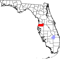
Location in the state of Florida
Florida's location in the U.S.Founded June 2, 1887 Seat Dade City Area
- Total
- Land
- Water
867.95 sq mi (2,248 km²)
744.85 sq mi (1,929 km²)
123.10 sq mi (319 km²), 14.18%Population
- (2010)
- Density
464,697
624/sq mi (240.9/km²)Website www.pascocountyfl.net Pasco County is a county located in the U.S. state of Florida. As of 2000, the population was 344,765. The July 1, 2007 census estimate according to the U.S. Census Bureau for the county is 462,715.[1] Its county seat is Dade City, Florida[2] which is in the northeast part of the county - somewhat removed from the main centers of population in the western half of the county. Duplicate county government offices and court facilities are also located in the New Port Richey area on the west side of the county. It is the 38th fastest growing county in the country with a 30.6% increase and has grown by 105,403 residents since the year 2000. Pasco, along with Hernando, Hillsborough, and Pinellas counties, comprise the Tampa-St. Petersburg-Clearwater, Florida Metropolitan Statistical Area.
Contents
History
 US Senator Samuel Pasco
Pasco County was created on June 2, 1887, from the southern third of Hernando County. The same legislation also created Citrus Country from the northern third of Hernando County. According to Horgan et al. (1992), the sponsors of the bill originally proposed the name 'Banner' (which was chosen by citizens of the area), but the bill was rejected. The sponsors then changed the name to Pasco (after Samuel Pasco, who had just been elected to the United States Senate). The legislature passed the revised bill unanimously.
The earliest towns were Anclote, Blanton, Dade City, Earnestville, Fort Dade, Macon (Trilby), Lacoochee and San Antonio. Citrus was an important industry when the county was formed, although a decline followed a freeze in 1895. Several large sawmills operated in the county in the early part of the twentieth century. During the Florida land boom of the 1920s, New Port Richey became the winter home of silent screen star Thomas Meighan and golfer Gene Sarazen; Meighan attempted to bring other Hollywood figures to the city. The county has experienced significant population growth since the 1960s. The growth began along the Gulf coast but is now occurring most rapidly in areas north of Tampa.
Geography
According to the 2000 census, the county has a total area of 867.95 square miles (2,248.0 km2), of which 744.85 square miles (1,929.2 km2) (or 85.82%) is land and 123.10 square miles (318.8 km2) (or 14.18%) is water.[3]
Adjacent counties
- Hernando County, Florida - north
- Sumter County, Florida - northeast
- Polk County, Florida - southeast
- Hillsborough County, Florida - south
- Pinellas County, Florida - southwest
Demographics
Historical populations Census Pop. %± 1890 4,249 — 1900 6,054 42.5% 1910 7,502 23.9% 1920 8,802 17.3% 1930 10,574 20.1% 1940 13,981 32.2% 1950 20,529 46.8% 1960 36,785 79.2% 1970 75,955 106.5% 1980 193,643 154.9% 1990 281,131 45.2% 2000 344,765 22.6% 2010 464,697 34.8% [4][5][6] As of the census[7] of 2000, there were 344,765 people, 147,566 households, and 99,016 families residing in the county. The population density was 463 people per square mile (179/km²). There were 173,717 housing units at an average density of 233 per square mile (90/km²). The racial makeup of the county was 93.70% White, 2.07% Black or African American, 0.35% Native American, 0.94% Asian, 0.03% Pacific Islander, 1.52% from other races, and 1.38% from two or more races. 5.69% of the population were Hispanic or Latino of any race.
There were 147,566 households out of which 23.50% had children under the age of 18 living with them, 54.60% were married couples living together, 8.90% had a female householder with no husband present, and 32.90% were non-families. 27.30% of all households were made up of individuals and 15.90% had someone living alone who was 65 years of age or older. The average household size was 2.30 and the average family size was 2.77.
In the county the population was spread out with 20.20% under the age of 18, 5.80% from 18 to 24, 24.10% from 25 to 44, 23.10% from 45 to 64, and 26.80% who were 65 years of age or older. The median age was 45 years. For every 100 females there were 92.20 males. For every 100 females age 18 and over, there were 89.10 males.
The median income for a household in the county was $32,969, and the median income for a family was $39,568. Males had a median income of $30,974 versus $23,802 for females. The per capita income for the county was $18,439. About 7.60% of families and 10.70% of the population were below the poverty line, including 15.20% of those under age 18 and 7.70% of those age 65 or over.
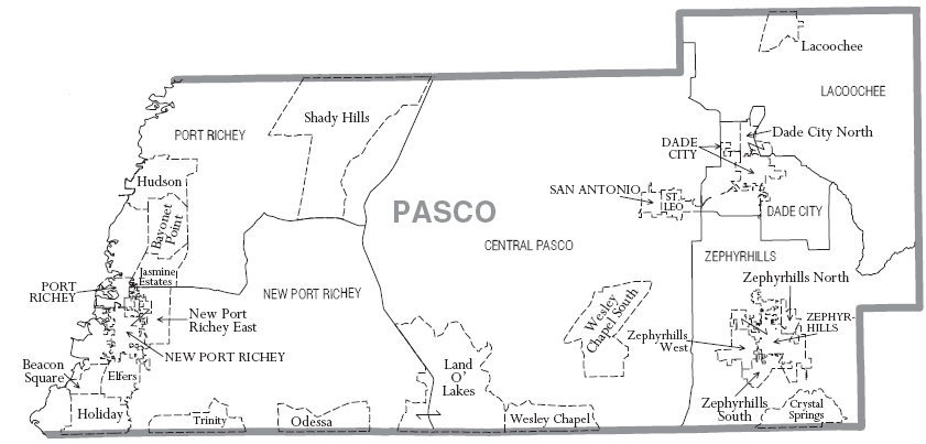
Municipalities
Incorporated
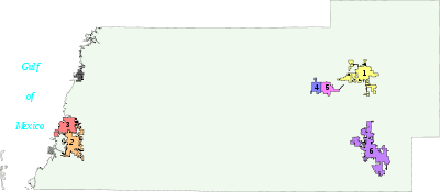 Incorporated municipalities of Pasco County. Numbers correspond to list at left.
- City of Dade City
- City of New Port Richey
- City of Port Richey
- City of San Antonio
- Town of St. Leo
- City of Zephyrhills
Unincorporated CDPs
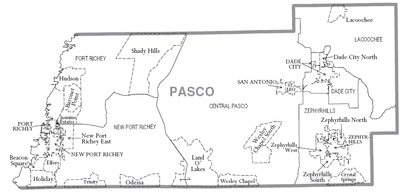 County map from http://www.census.gov
- Aripeka
- Bayonet Point
- Beacon Square
- Connerton
- Crystal Springs
- Dade City North
- Elfers
- Heritage Pines
- Holiday
- Hudson
- Jasmine Estates
- Key Vista
- Lacoochee
- Land O' Lakes
- Meadow Oaks
- Moon Lake
- New Port Richey East
- Odessa
- Pasadena Hills
- Quail Ridge
- River Ridge
- Shady Hills
- Trinity
- Trilby
- Wesley Chapel
- Zephyrhills North
- Zephyrhills South
- Zephyrhills West
Unincorporated communities not CDPs
- Blanton
- Darby
- Gulf Harbors
- Hudson Beach
- Jessamine
- Richland
- Seven Springs
- Saint Joseph
- Trilacoochee
Transportation
Aviation
- Zephyrhills Municipal Airport (ZPH) website
- Pilot Country Airport (X05) website
- Tampa North Aero Park (X39) website
- Hidden Lake Estates Airport (FA40, private airport near Moon Lake) website
Bus service
Pasco County Public Transportation provides bus service in West Pasco, Dade City and Zephyrhills.
Railroads
CSX operates three rail lines within the county. Amtrak formerly provided passenger rail service to Dade City, but the stop was terminated in late 2004.[8] The other two lines include the Brooksville Subdivision which runs close to US 41 and the Vitis Subdivision, which runs southeast into Lakeland.
Notable abandoned railroad lines include a former branch of the Atlantic Coast Line Railroad northwest of Trilacoochee(formerly Owensboro Junction) that became part of the Withlacoochee State Trail, a segment of the a Seaboard Air Line Railroad branch stretching from Zephyrhills to Trilacoochee, another line along the east side of US 301 that spanned from Sulphur Springs to Zephyrhills, part of the Orange Belt Railroad which ran from St. Petersburg and entered the county in what is today Trinity to Trilby(abandoned during the early-to-mid 1970's), and a branch of the Seaboard Air Line that ran through Holiday, Elfers and into New Port Richey. This line was truncated to Elfers in 1943, and eliminated during the 1980s.
Major roads
 Interstate 75 runs north and south across the eastern part of the county. Once a major connecting point with Tampa, I-75 has been made obsolete for western residents of the county by the Suncoast Parkway.
 Suncoast Parkway enters the county in the south halfway between Gunn Highway and US 41, and ends in the far northern part of the county at County Line Road (Exit 37), The Suncoast Parkway is a recently-constructed toll road that connects Pasco County with Hillsborough County, where it becomes the Veterans Expressway and heads directly into Tampa International Airport before reaching Interstate 275. SR 589 has four Pasco County exits: SR 54 (Exit 19), Ridge Road Extension (Future Exit 24), SR 52 (Exit 27), and County Line Road(Exit 37).
 U.S. Route 19 is a major commercial center running beside to the Gulf of Mexico on the western edge of the county, and used as a primary connecting route to cities down the west coast of Florida, including Tarpon Springs, Dunedin, Clearwater, and St. Petersburg to the south, as well as Spring Hill, Weeki Wachee, Homosassa and Crystal River to the north.
Alternate 19 is a former section of US 19 that runs closer to the Gulf of Mexico in Pinellas and southern Pasco County than US 19. U.S. Route 41 (Land O' Lakes Bouelvard) is the main south-to-north US Highway through Central Pasco County. It enters the county from Lutz in Hillsborough County and serves as a commerical strip through most of Land O' Lakes. Further north the road becomes more rural, passing through Gowers Corner, and eventually enters Masaryktown at the Hernando County Line.
 U.S. Route 98 runs northwest and southeast from Hernando County to Polk County. Concurrent with US 301 between Trilacoochee and Clinton Heights.
 U.S. Route 301(Fort King Highway/Gall Boulevard) is the main south-to-north U.S. highway in eastern Pasco County. It enters the county from Hillsborough River State Park in Hillsborough County and becomes the main road in Zephyrhills, Clinton Heights, and Dade City. North of Dade City, the road runs through Trilacoochee and Trilby before it enters Ridge Manor in Hernando County at a bridge over the Withlacoochee River.
 State Road 39 runs northwest and southeast from Plant City into US 301 in Zephyrhills
 County Road 41 (Fort King Highway/17th Street/21st Street/Blanton Road) begins as a hidden state road along US 301 until it branches off to the northwest as a county road in Zephyrhills and runs parallel to US 301 until it reaches Dade City. From here it moves further to the west through Blanton and Jessamine, and after crossing over I-75 curves back north into rural Hernando County where it becomes HCR 541.
 County Line Road (CR 578) is a major county road running entirely along the border with Hernando County beginning at US 19, intersects the Suncoast Parkway, and ends at US 41. Due to increased congestion, it is planned to be upgraded from two to four lanes, and possibly upgraded from a county road to a state road.
 State Road 52 (Colonel Schrader Memorial Highway) an east-west route that runs primarily through the center of the county from US 19 in Bayonet Point to US 98-301 in Dade City.
 State Road 54 (Gunn Highway/Fifth Avenue) another east-west road that runs through southern Pasco County, from US 19 near Holiday to US 301 in Zephyrhills.
 State Road 56 a 2002-constructed road between SR 54 and Bruce B. Downs Boulevard in Wesley Chapel. Planned to be extended to US 301 south of Zephyrhills.
 State Road 575 the northernmost state road in Pasco County.
 Bruce B. Downs Boulevard
 Rowan Road/East Lake Road (CR 77)
 Dale Mabry Highway
 Moon Lake Road/Decubellis Road/Massachusetts Avenue (Pasco CR 587) (N)
- Gunn Highway (CR 587) (S) A short north and south extension of Gunn Highway(SR 54) that runs through Northern Hillsborough County towards Dale Mabry Highway and Busch Boulevard.
 Little Road (CR 1) Major four to six lane county road in western Pasco County bypassing US 19 between southeast of Aripeka and Trinity.
 Trinity Boulevard(Pasco-Pinellas CR 996)
Education
Public schools in the County are operated by Pasco County Schools.
Pasco County has seen explosive growth in its student enrollment, increasing from 46,458 students in the 1999-2000 year to 65,126 in the 2007-2008 year, an increase of 18,668 or 40.2%. The projected enrollment for the 2007-2008 was 64,674, so the actual enrollment was 452 students over the projection. [2] [3] Yearly, the school district has grown 2,489 or 5.4%, which leads to building one new school a year.
High schools
- Anclote High School - Holiday
- Fivay High School - Hudson
- Gulf High School - New Port Richey
- Hudson High School - Hudson
- Land O Lakes High School - Land O' Lakes
- J. W. Mitchell High School - New Port Richey
- Pasco High School - Dade City
- Ridgewood High School - New Port Richey
- River Ridge High School - New Port Richey
- Sunlake High School - Land O' Lakes
- Wesley Chapel High School - Wesley Chapel
- Wiregrass Ranch High School - Wesley Chapel
- Zephyrhills High School - Zephyrhills
Middle schools
- Bayonet Point Middle School - New Port Richey
- Centennial Middle School - Dade City
- Crews Lake Middle School - Spring Hill (Opening August 2008)
- Chasco Middle School - Port Richey
- Gulf Middle School - New Port Richey
- Hudson Middle School - Hudson
- Dr. John Long Middle School - Wesley Chapel
- Pasco Middle School - Dade City
- Pine View Middle School - Land O' Lakes
- River Ridge Middle School - New Port Richey
- Charles S. Rushe Middle School - Land O' Lakes
- Seven Springs Middle School - New Port Richey
- Paul R. Smith Middle School - Holiday
- Raymond B. Stewart Middle School - Zephyrhills
- Thomas E. Weightman Middle School - Wesley Chapel
Elementary schools
- Anclote Elementary School - New Port Richey
- Calusa Elementary School - New Port Richey
- Centennial Elementary School - Dade City
- Chasco Elementary School - Port Richey
- Cotee River Elementary School - New Port Richey
- R. B. Cox Elementary School - Dade City
- Cypress Elementary School - New Port Richey
- Deer Park Elementary School - New Port Richey
- Denham Oaks Elementary School - Lutz
- Double Branch Elementary School - Wesley Chapel
- Fox Hollow Elementary School - Port Richey
- Mary Giella Elementary School - Shady Hills
- Gulf Highlands Elementary School - Port Richey
- Gulfside Elementary School - Holiday
- Gulf Trace Elementary School - Holiday
- Hudson Elementary School - Hudson
- Lacoochee Elementary School - Dade City
- Lake Myrtle Elementary School - Land O' Lakes
- Longleaf Elementary School - New Port Richey
- M. P. Locke Elementary School - New Port Richey
- J. M. Marlowe Elementary School - New Port Richey
- Moon Lake Elementary School - New Port Richey
- New River Elementary School - Wesley Chapel
- Northwest Elementary School - Hudson
- Oaksted Elementary School - Land O' Lakes
- Pasco Elementary School - Dade City
- Pine View Elementary School - Land O' Lakes
- Quail Hollow Elementary School - Wesley Chapel
- Richey Elementary School - New Port Richey
- San Antonio Elementary School - Dade City
- Sand Pine Elementary School - Wesley Chapel
- Sanders Memorial Elementary School - Land O' Lakes
- Schrader Elementary School - New Port Richey
- Seven Oaks Elementary School - Wesley Chapel
- Seven Springs Elementary School - New Port Richey
- Shady Hills Elementary School - Spring Hill
- Sunray Elementary School - Holiday
- C. W. Taylor Elementary School - Zephyrhills
- Trinity Elementary School - New Port Richey
- Trinity Oaks Elementary School - New Port Richey
- Veterans Elementary School - Wesley Chapel (Opening August 2008)
- Wesley Chapel Elementary School - Wesley Chapel
- West Zephyrhills Elementary School - Zephyrhills
- Woodland Elementary School - Zephyrhills
- Watergrass Elementary School - Wesley Chapel
Special education centers
- James Irvin Education Center - Dade City
- F. K. Marchman Technical Education Center - New Port Richey
- Moore Mickens Education Center - Dade City
- Harry Schwettman Education Center - New Port Richey
Colleges / universities
- Pasco-Hernando Community College
- Saint Leo University
- Trinity College of Florida
- Webster College
- Rasmussen College
Parks and recreation
Recreational areas include Hudson Beach, The New Port Richey Recreation & Aquatic Center, Veterans Memorial Park, J. Ben Harrill Recreation Complex F/K/A Holiday Rec Complex, the Jay Starkey Preserve, Werner-Boyce Salt Springs State Park, a section of the Suncoast Trail, a section of the Withlacoochee State Trail, Conner Preserve, Cypress Creek Preserve, Withlacoochee River Park, and Crews Lake Wilderness Park.[9] Kayaking, canoeing, sailing, power boating, jet skiing, and fishing are popular along the coast and large tracts are preserved from development.
Pasco County, with its accommodating laws, is home to a number of Florida's nudist parks and resorts. While there is not a clothing-optional beach in the county, there are no fewer than 8 nudist parks. The oldest is Lake Como Club just north of Tampa, while a world-class resort known as Caliente, was opened several years ago, The nudist industry and its related tourism is a significant source of tax revenue for the county.
References
- ^ http://www.census.gov/popest/counties/tables/CO-EST2007-01-12.xls
- ^ "Find a County". National Association of Counties. http://www.naco.org/Counties/Pages/FindACounty.aspx. Retrieved 2011-06-07.
- ^ "Census 2000 U.S. Gazetteer Files: Counties". United States Census. http://www.census.gov/tiger/tms/gazetteer/county2k.txt. Retrieved 2011-02-13.
- ^ http://www.census.gov/population/www/censusdata/cencounts/files/fl190090.txt
- ^ http://factfinder2.census.gov/faces/tableservices/jsf/pages/productview.xhtml?pid=DEC_10_PL_QTPL&prodType=table
- ^ http://mapserver.lib.virginia.edu/
- ^ "American FactFinder". United States Census Bureau. http://factfinder.census.gov. Retrieved 2008-01-31.
- ^ "St. Petersburg Times". Loss of Amtrak service shouldn't derail Dade City. http://www.sptimes.com/2004/10/29/Pasco/Loss_of_Amtrak_servic.shtml. Retrieved 2004-10-29.
- ^ [1]
- History of Pasco County (1943) by Jefferson Alexis Hendley.
- Horgan, James J., Alice F. Hall, and Edward J. Herrmann, The Historic Places of Pasco County, Pasco County Historical Preservation Committee, Pasco County, Florida.
External links
Government links/Constitutional offices
- Pasco County Board of County Commissioners
- Pasco County Supervisor of Elections
- Pasco County Property Appraiser
- Pasco County Sheriff's Office
- Pasco County Tax Collector
- Pasco County Office of Emergency Management
- Pasco Mosquito Control
- Pasco County Cooperative Extension Service
- Pasco County Public Transportation
- Pasco County Library System
Special districts
Judicial branch
- Pasco County Clerk of Courts
- Public Defender for the 6th Judicial Circuit serving Pinellas and Pasco Counties
- Office of the State Attorney, 6th Judicial Circuit
- Circuit and County Court for the 6th Judicial Circuit of Florida
Tourism links
Other sites

Hernando County Sumter County Gulf of Mexico 
 Pasco County, Florida

Pinellas County Hillsborough County Polk County Municipalities and communities of Pasco County, Florida Cities 
Town CDPs Unincorporated
communitiesAripeka | Darby | Gulf Harbors | Hudson Beach | Trilacoochee | Trilby
Tampa Bay Area Topics Tampa Bay · Climate · History · Media · Sports · Tampa International Airport · Hillsborough County Schools · Pinellas County Schools · University of South Florida
Central cities Smaller communities Pinellas Park · Temple Terrace · Brandon · Zeyphrhills · Plant City · Largo · Dunedin · Tarpon Springs · Lutz · Greater Sun CenterCities in wider region Counties in MSA Counties in wider region Region Outlying regions Southwest Florida · Florida Heartland · Big Bend ·
Fun CoastSee also: FloridaCategories:
- Florida counties
- Pasco County, Florida
- 1887 establishments
- Counties in the Tampa Bay Area


Wikimedia Foundation. 2010.