- Klarälven
-
Klarälven River 
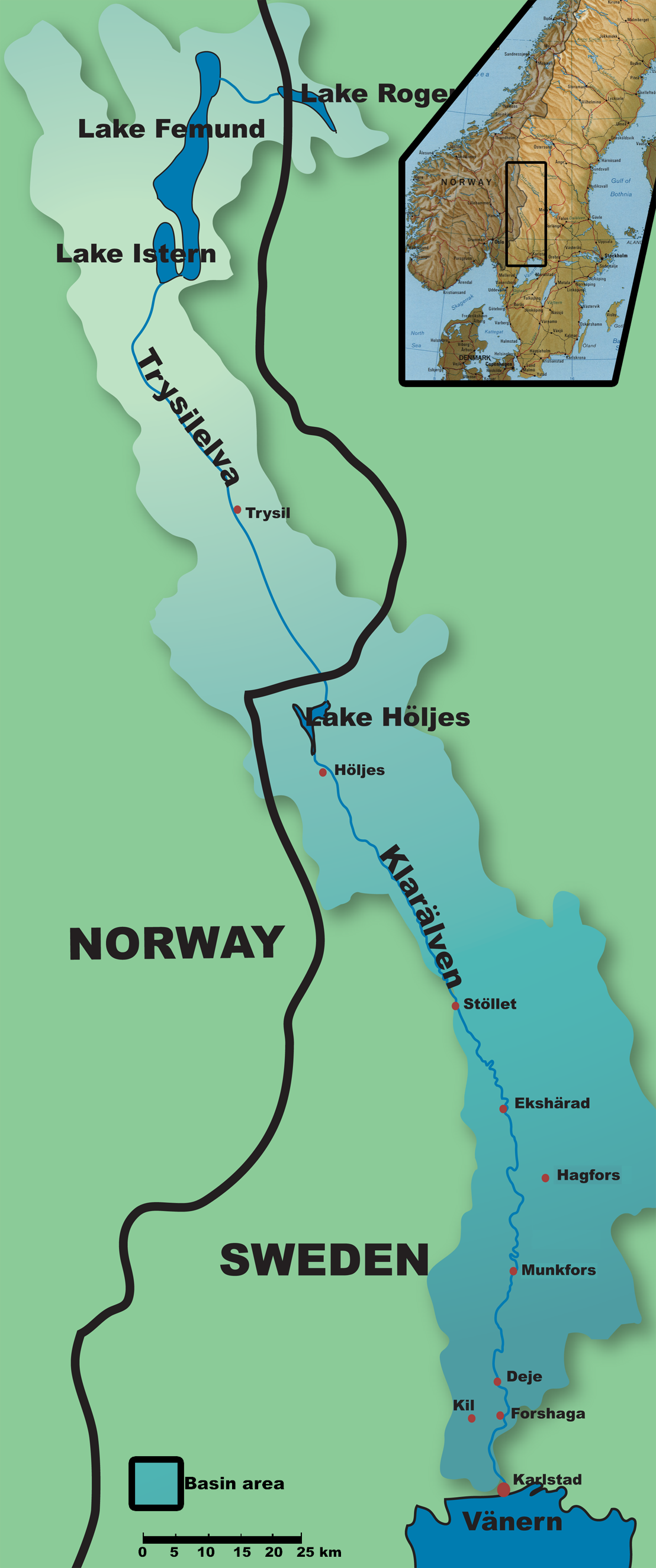
Countries Sweden, Norway Source Rogen and Femund Mouth Vänern - location Karlstad - elevation 44 m (144 ft) - coordinates 59°23′19″N 13°29′54″E / 59.38861°N 13.49833°E Length 460 km (286 mi) [1] Basin 11,820 km2 (4,564 sq mi) [1] Discharge - average 165 m3/s (5,827 cu ft/s) [1] - max 1,650 m3/s (58,269 cu ft/s) [1]  Map showing the main lakes connected to Klarälven, as well as its closest major towns.
Klarälven ("The clear river" in Swedish[2]) is a river flowing through Norway and Sweden. Together with Göta älv, which it is called as the river has passed through the lake Vänern, thus regarded as an entity, Göta älv-Klarälven is the longest river in Scandinavia and in the Nordic countries and its Swedish part the longest river of Sweden. These two rivers also has the largest drainage basin in the same areas, 50.229 km2 (included all the rivers that run into the lake Vänern), of which 42.468 km2 is located in Sweden, and the rest 7.761 in Norway.[3]
It emanates from Lake Rogen in Härjedalen, Sweden, and then passes through the Norwegian Hedmark, where it flows through the lake Femunden. There it is known as Femundelva and Trysilelva (before the nationalistic movement in the 19th century the river was called Klara even in Norway; today it is called Femundelva in the municipality of Engerdal and Trysilelva in the municipality of Trysil, reflecting strong local patriotism in Norway). The rest of the river, the longest part, flows through Värmland to ultimately discharge in a delta into Vänern at Karlstad.
In its turn, Vänern drains then into Göta älv, reaching the sea at Gothenburg.
The river has historically provided significant economic benefits, providing a suitable transport route for log driving, and currently is internationally recognized as excellent sport fishing waters.
Contents
Geography
 Map of the Klarälven delta and accompanying water bodies. Not showed here are the southern branches of the west part of the delta.
The watershed of Klarälven is commonly referred to as Klarälvsdalen (the Klarälv basin), where it accumulates much of its water on its journey to Vänern. Other important sources of water are the snowy mountains in the northern areas of the watershed area, providing substantial flows in the spring when the snow melts; annual floods are common.
Since the Ice Age, the mouth of Klarälven has moved from Forshaga to its current position at Karlstad,[4] and is still moving, albeit for different reasons, as the river carries substantial quantities of sand, cut from the outer edges of its meandering curves, causing the shoreline of Vänern to constantly move southward.
The heavy meandering of Klarälven results in numerous oxbow lakes, formed as a result of a too sharp curve, eventually causing the river to create a new, shorter path. An artificial islet, Gubbholmen found in central Karlstad has also been created as a result of the accumulation of 5000 tonnes sand transported each day during the spring flood.[5]
Entering the Karlstad region, the river delta splits into two main parts and eight smaller parts. The east part splits into two further main branches after passing Gubbholmen (eventually three branches). The west part splits into five branches.
Economic importance
There are some hydroelectric power plants in the river. These are the hydro powerplants from south to north.
- Forshaga powerplant in Forshaga,
- Dejefors powerplant in Dejeforsen, 20 MW, in the middle of central Deje,
- Munkfors powerplant in Munkfors, 33 MW,
- Skymnäsforsens powerplant in Skymnäsforsen in Skymnäsfors, 17 MW,
- Forshults powerplant in Forshult, 20 MW,
- Krakeruds powerplant in Krakerud, 22 MW,
- Skogaforsens powerplant in Skogaforsen i Skogafors 15 MW,
- Edsforsens powerplant in Edsforsen in Edsfors 9 MW och
- Höljes powerplant in Höljes, 130 MW.
Fishing
In recent years, the sport fishing of Klarälven has gained an international recognition for its Atlantic salmon and brown trout fisheries; these two species of fish are sought after by fly fishers. Competition for use of areas rich in the popular species is vigorous, and at high season the price of fishing licenses may be as high as 500 SEK ($68 USD) per day. Other measures are taken to ensure the survival of the fishery, including strict rules on the minimum sizes and quantities of fish allowed to be taken, as well as the requirement that unwanted fish, such as the northern pike, be killed when caught.[6]
Although the river was a busy log driving route, it has been reported that the fish populations of Klarälven has not suffered from the heavy activity, underwater life benefited from it, especially the grayling population. When the logging stopped in 1991, it was later reported that the beneficial effects were slowly disappearing as shore vegetation grew denser, providing a less favourable environment for the fish.[7]
As of 1997, an upper secondary school specializing in sport fishing education was established to meet the demands for skilled professionals to guide fishing tourism.[8]
Other tourism
Klarälven has clean and fresh water, suitable for bathing, although caution must be taken if bathing at a point before the river reaches its delta, as the currents can be treacherous.
Modern day tourist attractions in addition to sport fishing include canoeing, as well as rafting from Branäs to Edebäck.
Log driving
 A workforce of log drivers from Finnskoga, working at the Lusten separation point, Forshaga, taken 1918
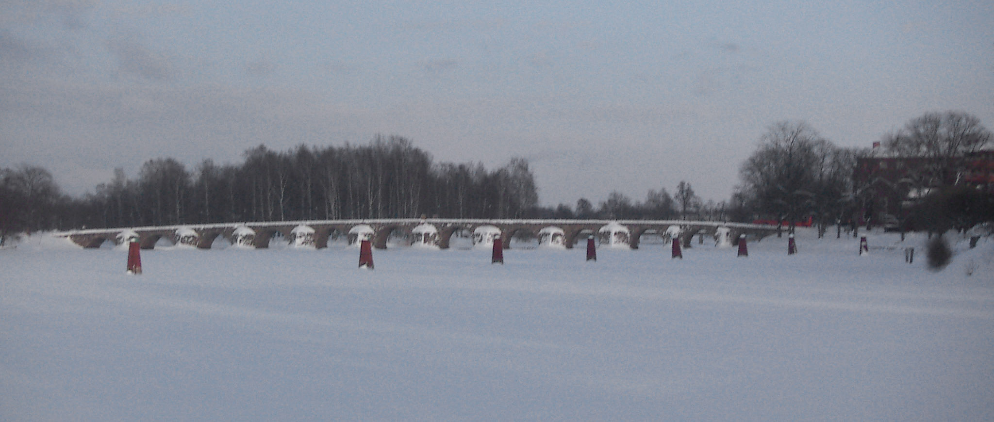
 A stone bridge crossing the Klarälven delta in Karlstad. The red constructions were made to catch passing logs. Such constructions can been seen throughout Klarälven.
Log driving has been traced back to the 17th century, although log driving increased to a significant level at the beginning of the 20th century, when the paper industry started to expand. Log driving was accomplished by dumping the harvested logs into the river, there they floated until the separation point at Forshaga. They were then held up by a floating structure resembling a fence until loggers could move out on the logs, identify them and guide them to their designated areas using special hooks. After grouping logs with the same company marks together, the logs would then be towed to their destinations.[9]
As many as 1500 persons were working seasonally, employed by the local log drivers' society, paid by the paper mills and forest owners. Although a risky job, the personnel were skilled and only one drowning incident was reported in the last 30 years of operation.[7]Out of the 19 Lusten boats used to tow the logs to their final destinations, only one remains in working condition today; Lusten 8, serving as a tourist attraction.[10]
After the shutdown of the flood driving industry in 1991, the remaining equipment was auctioned off, most was sold to the Forshaga Municipality, who used the equipment to found the log driving museum, using the old buildings used for the operations as its main building. Upon the shutdown of the flood driving in Klarälven, the practice of log driving in Sweden had officially come to its end.
References
- ^ a b c d "Klarälven" (in Swedish). Nationalencyklopedin. http://www.ne.se/klarälven. Retrieved 14 July 2010. (subscription required)
- ^ Page 168 of the Swedish Ethymological Dictionary Svenskt ortnamnslexikon, published 2003 by the institute of Språk- och folkminnesinstitutet, Uppsala. – The name Klarälven or Clara älv has been used since the beginning of the 18th century. Before that time the river had some other names, among them the most important name: Gautelfr i.e. Göta älv.
- ^ Swedish Meteorological and Hydrological Institute (in Swedish) (SMHI).
- ^ History of Forshaga published by the Genealogy Society of Värmland
- ^ Dubbskadeexkursion den 22 juni
- ^ Rules for sport fishing
- ^ a b Lundén, Bo. Flottningen på Klarälven (1986)
- ^ SportfiskeAkademin - om skolan
- ^ Flottningens historia on Museum of Värmland
- ^ Forshaga kanal
Categories:- Rivers of Sweden
- Värmland


Wikimedia Foundation. 2010.