- Myrtle Avenue Line (surface)
-
This article is about the surface line on Myrtle Avenue, from Downtown Brooklyn east to Ridgewood, Queens. For the continuation along Myrtle Avenue to Richmond Hill, Queens, see Richmond Hill Line.
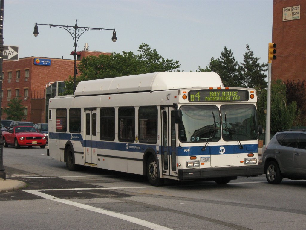
The Myrtle Avenue Line is a surface transit line on Myrtle Avenue in Brooklyn, New York City, United States. It was the first streetcar line in Brooklyn, built by the Brooklyn City Railroad, and it is now the B54 bus route, operated by MTA New York City Bus' Fresh Pond Depot in Ridgewood, Queens. It should not be confused with the BMT Myrtle Avenue Line, a separate subway line that also operates along Myrtle Avenue.
Contents
B54 bus route
The B54 bus route runs between Jay Street and Willoughby Street near the Jay Street – MetroTech subway station in Downtown Brooklyn and Palmetto Street and Wyckoff Avenue near the Myrtle–Wyckoff Avenues subway station in Ridgewood via Myrtle Avenue at all times.
The route serves MetroTech Center, the Polytechnic Institute of New York University, the New York City College of Technology, the Brooklyn Supreme & Family Court, the Brooklyn Civic Center, the Brooklyn Civil Court, Long Island University, Junior's, the Brooklyn Hospital Center, the University Towers Houses, the Raymond Ingersoll Houses, Fort Greene Park, the Walt Whitman Houses, Willoughby Walk, the Pratt Institute, the Marcy Houses, the Tompkins Houses, Sumner Housing, and the Woodhull Medical and Mental Health Center. It also connects with the B13, B15 to JFK Airport, B25, B26, B38 Limited, B41 Limited, B43, B44 Limited, B45, B46 Limited, B47, B48, B52, B57, B60, B61, B62, B65, B67, B69, B103 Limited, Q55, and Q58 Limited bus routes and the following subway stations:
- Jay Street – MetroTech on the IND Culver Line, IND Fulton Street Line, and BMT Fourth Avenue Line (A
 C
C  F )
F ) - Hoyt Street – Fulton Mall on the IRT Eastern Parkway Line (2 3 )
- Nevins Street on the IRT Eastern Parkway Line (2 3 4 5
 )
) - DeKalb Avenue on the BMT Brighton Line and BMT Fourth Avenue Line (B D
 N Q R )
 - Myrtle–Willoughby Avenues on the IND Crosstown Line (G )
- Myrtle Avenue on the BMT Jamaica Line (J M Z
 )
) - Central Avenue on the BMT Myrtle Avenue Line (M )
- Knickerbocker Avenue on the BMT Myrtle Avenue Line (M )
- Myrtle–Wyckoff Avenues on the BMT Canarsie Line and BMT Myrtle Avenue Line (L M )
History
The Brooklyn City Railroad opened its first line - the Myrtle Avenue Line - on July 3, 1854.[1][2][3][4] The initial line began at Fulton Ferry, and ran southeast on Fulton Street and east on Myrtle Avenue to a temporary terminus at Marcy Avenue. Construction to Broadway (then Division Avenue) at Bushwick was completed in December 1854.[5][6][7]
In August 1879, the City Railroad extended its Myrtle Avenue Line one block east from Broadway to Bushwick Avenue, and acquired trackage rights over the Bushwick Railroad's Bushwick Avenue Line (which used Myrtle Avenue east of Bushwick Avenue) to Myrtle Avenue Park in Ridgewood, Queens. At Ridgewood, connections could be made to the Cypress Hills Line and soon the Lutheran Line, two steam dummy lines to local cemeteries.[8] The City Railroad leased the Bushwick Railroad, which included these cemetery lines, on July 27, 1888.[9]
Myrtle Avenue horse cars were replaced with electric trolleys in mid-1893.[10] The line was one of the four extended over the Brooklyn Bridge to Park Row in Lower Manhattan on February 15, 1898, preceded by only the Graham Avenue Line.[11] Cars reached the bridge by turning off Myrtle Avenue onto Washington Street, on trackage originally built for the DeKalb Avenue Line, and turning into Sands Street on trackage from the Graham Avenue Line to the bridge.[12] The Myrtle Avenue Line was also one of the seven moved to the new structure through the Sands Street elevated station, on the Brooklyn side of the bridge, on September 28, 1908; cars returned to the old route along Myrtle Avenue and Fulton Street to the split for the new structure at Tillary Street.[13][14]
After this elevated structure was removed in 1944,[15] the Myrtle Avenue Line was combined with the Court Street Line, which had also used this structure, to form the Myrtle Avenue and Court Street Line. This new route began at Court Street and Hamilton Avenue in Gowanus, and ran north on Court Street to Borough Hall and east on Myrtle Avenue to Ridgewood. Trolleys were replaced by buses in the late 1940s, and the route was split into the B54 on Myrtle Avenue and the B66 on Court Street.[16] (The B66 is now part of the B75.)
The Myrtle Avenue Line, under the Myrtle Avenue Elevated for its entire length since 1889,[17][18] became more important on October 4, 1969, when the elevated was abandoned west of Broadway.[19] A special transfer was given to the B54 between the Jay Street–Borough Hall and Broadway–Myrtle Avenue subway stations, allowing travelers who had used the Myrtle Avenue Elevated to make the connection via the bus.[20]
The Myrtle-Culver Line was a summer-only service connecting Ridgewood with Coney Island. It ran west on Myrtle Avenue from Ridgewood to Vanderbilt Avenue, and turned south there, using the Vanderbilt Avenue Line and Culver Line trackage to Coney Island.[12]
See also
- Brooklyn Bridge trolleys
- Myrtle Avenue Line (elevated)
- Greenpoint Line, which used the Myrtle Avenue trackage west of Classon Avenue
- Ralph and Myrtle Avenues Line, a combination of the Myrtle Avenue and Ralph Avenue Lines
References
- ^ "The New Railroads in the City - Trial Trip". Brooklyn Daily Eagle: p. 2. July 3, 1854. http://eagle.brooklynpubliclibrary.org/Default/Scripting/ArchiveView.asp?BaseHref=BEG/1854/07/03&Page=2&skin=BE.
- ^ "Railroad Accidents". Brooklyn Daily Eagle: p. 2. July 5, 1854. http://eagle.brooklynpubliclibrary.org/Default/Scripting/ArchiveView.asp?BaseHref=BEG/1854/07/05&Page=2&skin=BE.
- ^ "The City Railroads". Brooklyn Daily Eagle: p. 2. July 5, 1854. http://eagle.brooklynpubliclibrary.org/Default/Scripting/ArchiveView.asp?BaseHref=BEG/1854/07/05&Page=2&skin=BE.
- ^ "Questions Answered". Brooklyn Daily Eagle: p. 4. June 4, 1893. http://eagle.brooklynpubliclibrary.org/Default/Scripting/ArchiveView.asp?BaseHref=BEG/1893/06/04&Page=4&skin=BE.
- ^ "Brooklyn Common Council". Brooklyn Daily Eagle: p. 2. December 23, 1854. http://eagle.brooklynpubliclibrary.org/Default/Scripting/ArchiveView.asp?BaseHref=BEG/1854/12/23&Page=2&skin=BE.
- ^ Brian J. Cudahy, How We Got to Coney Island: Development of Mass Transportation in Brooklyn and Kings County, 2002, pages 25 to 26
- ^ Jeffrey A Kroessler, New York, Year by Year: A Chronology of the Great Metropolis, 2002, page 100
- ^ "Myrtle Avenue Extension". Brooklyn Daily Eagle: p. 4. August 18, 1879. http://eagle.brooklynpubliclibrary.org/Default/Scripting/ArchiveView.asp?BaseHref=BEG/1879/08/18&Page=4&skin=BE.
- ^ "The Lease Ratified". Brooklyn Daily Eagle: p. 4. July 27, 1888. http://eagle.brooklynpubliclibrary.org/Default/Scripting/ArchiveView.asp?BaseHref=BEG/1888/07/27&Page=4&skin=BE.
- ^ "How the New Tax is Levied". Brooklyn Daily Eagle: p. 10. July 17, 1893. http://eagle.brooklynpubliclibrary.org/Default/Scripting/ArchiveView.asp?BaseHref=BEG/1893/07/17&Page=10&skin=BE.
- ^ "Thousands Cross in Bridge Trolleys". Brooklyn Daily Eagle: p. 16. February 16, 1898. http://eagle.brooklynpubliclibrary.org/Default/Scripting/ArchiveView.asp?BaseHref=BEG/1898/02/16&Page=16&skin=BE.
- ^ a b Carl-Axel Rheborg, Pocket Guide to New York, 1906, page 65
- ^ Brian J. Cudahy, How We Got to Coney Island: Development of Mass Transportation in Brooklyn and Kings County, 2002, page 222
- ^ New York Department of Plant and Structures, Brooklyn Bridge, 1883-1933 (also at Google Books)
- ^ Electric Railroaders' Association, Headlights: "After the abandonment of elevated service [which was March 5, 1944], the "el" terminals at the ends of the bridge were demolished together with the approaches mentioned [the elevated trolley structure]. Overhead wire was strung along the elevated tracks on the bridge and a number of new switches together with new track was constructed together with 7 new loops at Park Row... Trolleys began using the old "el" tracks Dec. 15th, 1944."
- ^ New York Board of Transportation, Report for the Three and One-half Years Ending June 30, 1949
- ^ "To Greenwood on Thursday". Brooklyn Daily Eagle: p. 1. August 14, 1889. http://eagle.brooklynpubliclibrary.org/Default/Scripting/ArchiveView.asp?BaseHref=BEG/1889/08/14&Page=1&skin=BE.
- ^ "The Fifth Avenue Elevated to Greenwood". Brooklyn Daily Eagle: p. 6. August 15, 1889. http://eagle.brooklynpubliclibrary.org/Default/Scripting/ArchiveView.asp?BaseHref=BEG/1889/08/15&Page=6&skin=BE.
- ^ New York Times, 1,200 on Last Trip on Myrtle Ave. El, October 4, 1969, page 23
- ^ B-54 Myrtle Avenue Route transfers: towards Jay Street–Borough Hall and Broadway–Myrtle Avenue
Former streetcar lines in Brooklyn and other B&QT lines 2 Bergen - 3 Sumner - 5 St. Johns - 7 Tompkins - 9 Rockaway - 10 Ralph-Rockaway - 11 Ralph - 13 Gravesend-Church - 14 Wilson - 15 Crosstown - 16 Graham - 17 Greenpoint - 19 Nassau - 21 DeKalb - 24 Broadway - 25 Fulton - 26 Putnam - 27 Jamaica - 28 Erie Basin - 29 Meeker-Marcy - 30 Eighth - 31 86th - 32 Fifth - 33 Hamilton - 34 Bay Ridge - 35 Church - 36 Sea Gate - 37 Third - 38 West End - 41 Flatbush - 42 Holy Cross - 43/44 Nostrand - 46 Utica-Reid - 47 Franklin - 48 Lorimer - 49 Ocean - 50 Bushwick - 50 McDonald - 52 Greene-Gates - 53 Metropolitan - 54 Myrtle-Court - 55 Richmond Hill - 56 Union Av - 57 Flushing - 58 Flushing-Ridgewood - 59 Grand - 67 Seventh - 68 Smith-Coney Island - 69 McDonald-Vanderbilt - 71 Union St - 73 Norton's Point - 75 Smith St - 77 Fifteenth - 82 Bergen Beach - 83 Norton's Point ShuttleAdams-Boerum - Brooklyn Bridge - Brooklyn & North River - Court - Furman - Hicks - Hoyt-Sackett - Hudson - Manhattan Bridge 3¢ - Montague - New Lots - Queensboro BridgeCurrent bus routes in Brooklyn  Categories:
- Streetcar lines in Brooklyn
- MTA Regional Bus routes
- Jay Street – MetroTech on the IND Culver Line, IND Fulton Street Line, and BMT Fourth Avenue Line (A
Wikimedia Foundation. 2010.