- Claxton, Norfolk
-
Coordinates: 52°34′32″N 1°27′32″E / 52.57567°N 1.45888°E
Claxton 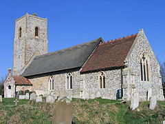
St. Andrew's, Claxton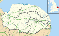
 Claxton
Claxton shown within NorfolkArea 4.07 km2 (1.57 sq mi) Population 244 - Density 60 /km2 (160 /sq mi) OS grid reference TG344031 Parish Claxton District South Norfolk Shire county Norfolk Region East Country England Sovereign state United Kingdom Post town NORWICH Postcode district NR14 Police Norfolk Fire Norfolk Ambulance East of England EU Parliament East of England List of places: UK • England • Norfolk Claxton is a small village 8.5 miles (13.7 km) south-east of Norwich, and south of the River Yare, between Rockland St. Mary and Loddon in South Norfolk, England. In the 2001 census it contained 85 households and a population of 244.[1] Just to the south lie the small villages of Ashby St Mary and Carleton St Peter.
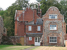
To the east of the village are the remains of Claxton Castle, which dates from the mid-14th century, licences to crenellate having been granted in 1340 and 1376.[2] Situated on private land in the grounds of Claxton Manor House it comprises a massive brick-and-flint wall 130 feet (40 m) long with six bastions. Claxton Manor House itself was built in the reign of Elizabeth I but has a Victorian façade. The Manor was bought in 1946 by Major Derek Allhusen, who achieved fame as a horseman winning team gold and individual silver at the 1968 Summer Olympics. Derek Allhusen died in 2000.[3]. EPD http://new.edp24.co.uk/content/news/story.aspx?brand=EDPOnline&category=News&tBrand=edponline&tCategory=news&itemid=NOED03%20Aug%202008%2018%3A20%3A39%3A013</ref> To the south-west of the village lies Claxton Church. It is thought that the Saxon settlement which would have been built around it moved down to the marsh edge in the Middle Ages. The church has a thatched scissor-beam roof with basketweave sarking. The flint tower is unbuttressed and dates from the 14th century, though much restored.
 C14 ruins of Claxton Castle
 Claxton Manor House
 Claxton Opera
Between 1926 and 1936 a narrow gauge railway ran the 1 mile (1.6 km) from Claxton Manor Farm in the village north to the south bank of the River Yare. In 1928 it was extended south to Staines Barn, just east of the church. It was used to transport sugar beet bound for the factory at Cantley which was loaded onto wherries at the river. It used 2-foot (610 mm) gauge jubilee track and a converted Model T Ford as motive power.[3]
A windmill once stood at the eastern end of the village on Mill Lane. It was demolished in 1945 as it was thought to be a landmark for enemy aircraft. A Spitfire crash-landed in Claxton Marsh to the north of the village in the same year and is now on display at Flixton Aviation Museum.
Claxton no longer has a pub (closed 1974), post office (closed 1977) or school (closed 1981), although a combined shop and petrol station survived until 2002. It does have a village hall which it shares with Carleton St Peter. The current hall was opened in 1984 and is home to a social club founded in 1987 and licensed for the sale of alcohol.
Claxton is served by bus route 001 operated by Anglian Coaches providing two services a day into Norwich via Rockland St Mary, Bramerton and Kirby Bedon — Timetable. It also lies on National Cycle Route 1 on its route from Norwich to Beccles via Loddon.
Founded in 2004, Claxton Opera stages annual performances in the Old Meeting House. This was once a Strict and Particular Baptist chapel erected in the 1750s and could hold 500 in its heyday, but finally closed for worship in 1943. It is now a private house but the living room becomes a theatre for two or three months a year when the annual opera is staged.
South of the village on the banks of Carleton Beck lies Ducan's Marsh, a Site of Special Scientific Interest and one of the richest areas of unimproved wet grassland in East Norfolk.[4]
There is now an official village web-site with up to date information on village and parish affairs.
External links
- Ordnance Survey Pathfinder (1:25000) map of Claxton
- Claxton Church
- Claxton Castle
- Claxton Smock mill
- Ducan's Marsh
- Claxton Opera
- http://www.claxtonpc.norfolkparishes.gov.uk
Further reading
Claxton: A Thousand Years of Village Life (2005) (Millennium Awards Fellowship)
References
- ^ Claxton parish information [South Norfolk Council]
- ^ Claxton Castle
- ^ a b Claxton, A Thousand Years of Village Life (2005).
- ^ http://www.english-nature.org.uk/citation/citation_photo/1000294.pdf
Categories:- South Norfolk
- Villages in Norfolk
- Civil parishes in Norfolk


Wikimedia Foundation. 2010.