- Derry Cairngorm
-
Derry Cairngorm 
Derry Cairngorm seen from Càrn a' Mhàim, 3.5 km to the SW. The Sròn Riach ridge descending from Ben Macdui is in the foregroundElevation 1,155 m (3,789 ft) Prominence 141 m (463 ft) Parent peak Ben Macdui Listing Munro Translation Blue Cairn of Derry (Gaelic) Pronunciation Scottish Gaelic: [ˈkʰaːrˠn ˈkɔɾɔm ən̪ˠ ˈt̪ɤɾʲə] Location Location Cairngorms,  Scotland
Range Grampians Topo map OS Landranger 36, OS Explorers 403 OS grid NJ044013 Listed summits of Derry Cairngorm Name Grid ref Height Status Creagan a' Choire Etchachan NO012996 1108 m (3635 ft) Munro Top Sgurr an Lochan Uaine NO025991 983 m (3225 ft) Munro Top  Looking west from the summit of Derry Cairngorm to Ben Macdui and Coire Sputan Dearg.
Derry Cairngorm (Scottish Gaelic: Càrn Gorm an Doire) is a Scottish mountain in the Cairngorms range, 14 kilometres north west of Braemar in the county of Aberdeenshire.
Contents
Overview
With a height of 1155 m (3789 ft), it is the 21st highest Munro.[1] Derry Cairngorm is regarded as part of the central group of Cairngorm hills, along with Ben Macdui and Càrn a' Mhàim. Macdui stands four km to the north west and they are connected by a col with a height of 1014 m. The mountain was originally named An Carn Gorm but was renamed to Carn Gorm an Doire to avoid confusion with the nearby Cairn Gorm. The name has now been anglicised to Derry Cairngorm: the original Gaelic means “Blue cairn of Derry”. Derry is the anglicisation of doire, or doireach, meaning wooded, a reference to the Scots pines that adorn the southern slope of the mountain near Derry Lodge, remnants of the old Caledonian Forest. The hill is well seen from Inverey and often appears as dark blue in colour, however from other angles it takes on a distinct pink tinge as result of its granite rocks (see photo).[2]
Geography
Derry Cairngorm is an eight-kilometre-long ridge-type mountain that runs north to south, it rises from Glen Luibeg in the south and concludes at Coire Etchachan in the north, where it is joined to Beinn Mheadhoin. Coire Etchachan has Loch Etchachan lying within it, at a height of 930 metres the highest notable expanse of water in Great Britain.[3] It has trout living in it. On its eastern flanks the mountain falls steeply and craggily into Glen Derry while its western flanks descend more moderately to the valley of the infant Luibeg Burn. Derry Cairngorm is characterised by large granite boulders on its higher slopes which make walking in the summit area difficult, the walker often having to resort to hopping between boulders. This large expanse of boulders is formed by the action of freezing and thawing in a periglacial environment and is known as a blockfield or felsenmeer.[4] All drainage from the mountain flows south via the Derry and Luibeg burns to join the River Dee, eventually reaching the sea at Aberdeen.
Derry Cairngorm has two subsidiary summits listed in the Munro Tables. Creagan a' Choire Etchachan (1108 m) stands 1.5 km north of the main summit and is a fine viewpoint down into the wild Coire Etchachan. Sgurr an Lochan Uaine (983 m), 1.5 km north east, is seen as just a hump near the cliff edge from the main summit but is more distinct when seen from Glen Derry, which it overlooks. Eight hundred metres south of the summit lies an unnamed point with a height of 1040 m. This is the former "top" called Little Cairngorm, which was deleted from the tops' list in 1974.[5]
Ascents
 Hutchinson Memorial Hut and Creagan a'Choire Etchachan, as passed on the approach to Derry Cairngorm from Derry Lodge
Derry Cairngorm can be climbed from either the east or west sides of the Cairngorm range and either singly or in combination with other hills. The ascent from the east starts at the Linn of Dee car park (NO065901) and takes the track to Derry Lodge (a bicycle can used as far as the lodge). The southern ridge of Derry Cairngorm is then ascended to reach the summit, crossing Little Cairngorm on the way. The mountain can be climbed from the Cairn Gorm ski centre car park (NH989061) and involves climbing and crossing Ben Macdui before continuing to Derry Cairngorm. The Ben Macdui summit plateau can be a hazardous place in mist and bad weather. The ascent from the Linn of Dee can also include climbing Càrn a' Mhàim and Ben Macdui. This is a long hard day's walking of over 30 kilometres, although the use of a bicycle to and from Derry Lodge will help quite a bit. The view from the summit is very good with all the Cairngorm giants looking fine.[6]
References
- The Munros Donald Bennett et al.: Scottish Mountaineering Trust: ISBN 0-907521-13-4
- The High Mountains of Britain and Ireland, Irvine Butterfield, ISBN 0-906371-30-9
- Hamish’s Mountain Walk, Hamish Brown, ISBN 1-898573-08-5
- The Magic Of The Munros, Irvine Butterfield, ISBN 0-7153-2168-4
Footnotes
- ^ www.scottishsport.co.uk. Lists Munros in height order.
- ^ "The Magic of the Munros" Page 113 Gives information on translation.
- ^ living.scotsman.com. Says Loch Etchachan is the highest body of water in the UK.
- ^ www.fettes.com. Gives details of Derry Cairngorm blockfield.
- ^ Online version of Munros Tables. Gives details of subsidiary tops.
- ^ "The Munros" Page 122 Gives details of ascents.
Coordinates: 57°03′44″N 3°37′18″W / 57.0622°N 3.6217°W
 Ben Avon · Beinn a' Bhùird · Beinn Bhreac · Beinn a' Chaorainn · Beinn Bhrotain · Ben Macdui · Beinn Mheadhoin · Braeriach · Bynack More · Cairn Gorm · Cairn Toul · Càrn a' Mhàim · Derry Cairngorm · The Devil's Point · Monadh Mòr · Mullach Clach a' Bhlàir · Sgòr Gaoith · Sgòr an Lochain Uaine
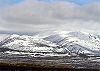
List of Munros Categories:- Munros
- Marilyns of Scotland
- Mountains and hills of the Eastern Highlands
- Mountains and hills of Aberdeenshire
- Places and placenames on Mar Lodge Estate


Wikimedia Foundation. 2010.