- Colorado metropolitan areas
-
 Main article: State of Colorado
The metropolitan areas of the State of Colorado include the urban statistical areas defined by the United States Office of Management and Budget and regions of urban population defined by other organizations.
Contents
Census statistical areas
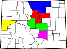
 An enlargeable map of the 14 Core Based Statistical Areas in the State of Colorado
 See also: Colorado census statistical areas
The United States Office of Management and Budget {OMB) has defined one Combined Statistical Area (CSA),[1] seven Metropolitan Statistical Areas (MSAs),[2] and seven Micropolitan Statistical Areas (μSAs)[3] in the State of Colorado.[4] At the 2010 United States Census, 91.86% of Coloradans lived in one of these areas.[5]
The following table describes the census statistical areas of the State of Colorado with the following information:
- The name of the Combined Statistical Area (CSA), if one is defined[4]
- The CSA population as of April 1, 2010, as enumerated by the 2010 United States Census,[5]
- The name of the Core Based Statistical Area (CBSA)[4]
- The CBSA population as of April 1, 2010, as enumerated by the 2010 United States Census,[5]
- The name of the county[6]
- The county population as of April 1, 2010, as enumerated by the 2010 United States Census,[5]
- The county population as of April 1, 2000, as enumerated by the 2000 United States Census,[5]
- The percent county population change from April 1, 2000, to April 1, 2010.[5]
Census Statistical Areas in the State of Colorado
Combined Statistical Area 2010 Census Core Based Statistical Area 2010 Census County 2010 Census 2000 Census Pop Change Denver-Aurora-Boulder, CO CSA 3,090,874 Denver-Aurora-Broomfield, CO MSA 2,543,482 City and County of Denver, Colorado 600,158 554,636 +8.21% Arapahoe County, Colorado 572,003 487,967 +17.22% Jefferson County, Colorado 534,543 527,056 +1.42% Adams County, Colorado 441,603 363,857 +21.37% Douglas County, Colorado 285,465 175,766 +62.41% City and County of Broomfield, Colorado 55,889 0 NA Elbert County, Colorado 23,086 19,872 +16.17% Park County, Colorado 16,206 14,523 +11.59% Clear Creek County, Colorado 9,088 9,322 −2.51% Gilpin County, Colorado 5,441 4,757 +14.38% Boulder, CO MSA 294,567 Boulder County, Colorado 294,567 291,288 +1.13% Greeley, CO MSA 252,825 Weld County, Colorado 252,825 180,936 +39.73% Colorado Springs, CO MSA 645,613 El Paso County, Colorado 622,263 516,929 +20.38% Teller County, Colorado 23,350 20,555 +13.60% Fort Collins-Loveland, CO MSA 299,630 Larimer County, Colorado 299,630 251,494 +19.14% Pueblo, CO MSA 159,063 Pueblo County, Colorado 159,063 141,472 +12.43% Grand Junction, CO MSA 146,723 Mesa County, Colorado 146,723 116,255 +26.21% Edwards, CO μSA 59,507 Eagle County, Colorado 52,197 41,659 +25.30% Lake County, Colorado 7,310 7,812 −6.43% Durango, CO μSA 51,334 La Plata County, Colorado 51,334 43,941 +16.82% Cañon City, CO μSA 46,824 Fremont County, Colorado 46,824 46,145 +1.47% Montrose, CO μSA 41,276 Montrose County, Colorado 41,276 33,432 +23.46% Fort Morgan, CO μSA 28,159 Morgan County, Colorado 28,159 27,171 +3.64% Silverthorne, CO μSA 27,994 Summit County, Colorado 27,994 23,548 +18.88% Sterling, CO μSA 22,709 Logan County, Colorado 22,709 20,504 +10.75% Other urban regions
In addition to the U.S. Census Bureau defined areas above, there are several other defined regions of urban population in Colorado.
 The skyline of downtown Denver with Speer Boulevard in the foreground.
Denver Core Metropolitan Area
 An enlargeable map of the 4-county Denver Core Metropolitan Area
The 4-county Denver Core Metropolitan Area dates from the creation of the City and County of Denver in 1902.[5]
Denver Core Metropolitan Area County 2010 Census 2000 Census Pop Change Adams County, Colorado 441,603 363,857 +21.37% Arapahoe County, Colorado 572,003 487,967 +17.22% City and County of Denver, Colorado 600,158 554,636 +8.21% Jefferson County, Colorado 534,543 527,056 +1.42% Total 2,148,307 1,933,516 +11.11% Denver Central Metropolitan Area
 An enlargeable map of the 6-county Denver Central Metropolitan Area
The 6-county Denver Central Metropolitan Area also includes Douglas County and the City and County of Broomfield.[5]
Denver Central Metropolitan Area County 2010 Census 2000 Census Pop Change Adams County, Colorado 441,603 363,857 +21.37% Arapahoe County, Colorado 572,003 487,967 +17.22% City and County of Broomfield, Colorado 55,889 0 NA City and County of Denver, Colorado 600,158 554,636 +8.21% Douglas County, Colorado 285,465 175,766 +62.41% Jefferson County, Colorado 534,543 527,056 +1.42% Total 2,489,661 2,109,282 +18.03% Denver Region
 An enlargeable map of the 9-county Denver Regional Council of Governments
The 9-county Denver Region of the Denver Regional Council of Governments also includes Boulder County, Gilpin County, and Clear Creek County.[5]
Denver Region County 2010 Census 2000 Census Pop Change Adams County, Colorado 441,603 363,857 +21.37% Arapahoe County, Colorado 572,003 487,967 +17.22% Boulder County, Colorado 294,567 291,288 +1.13% City and County of Broomfield, Colorado 55,889 0 NA Clear Creek County, Colorado 9,088 9,322 −2.51% City and County of Denver, Colorado 600,158 554,636 +8.21% Douglas County, Colorado 285,465 175,766 +62.41% Gilpin County, Colorado 5,441 4,757 +14.38% Jefferson County, Colorado 534,543 527,056 +1.42% Total 2,798,757 2,414,649 +15.91% North Central Colorado Urban Area
 An enlargeable map of the 13-county North Central Colorado Urban Area
The 13-county North Central Colorado Urban Area comprises the four contiguous Metropolitan Statistical Areas of north central Colorado.[7][5]
North Central Colorado Urban Area Core Based Statistical Area 2010 Census County 2010 Census 2000 Census Pop Change Denver-Aurora-Broomfield, CO MSA 2,543,482 City and County of Denver, Colorado 600,158 554,636 +8.21% Arapahoe County, Colorado 572,003 487,967 +17.22% Jefferson County, Colorado 534,543 527,056 +1.42% Adams County, Colorado 441,603 363,857 +21.37% Douglas County, Colorado 285,465 175,766 +62.41% City and County of Broomfield, Colorado 55,889 0 NA Elbert County, Colorado 23,086 19,872 +16.17% Park County, Colorado 16,206 14,523 +11.59% Clear Creek County, Colorado 9,088 9,322 −2.51% Gilpin County, Colorado 5,441 4,757 +14.38% Fort Collins-Loveland, CO MSA 299,630 Larimer County, Colorado 299,630 251,494 +19.14% Boulder, CO MSA 294,567 Boulder County, Colorado 294,567 291,288 +1.13% Greeley, CO MSA 252,825 Weld County, Colorado 252,825 180,936 +39.73% Total 3,390,504 2,881,474 +17.67% South Central Colorado Urban Area
 An enlargeable map of the four-county South Central Colorado Urban Area
The four-county South Central Colorado Urban Area comprises the Colorado Springs Metropolitan Statistical Area, the Pueblo Metropolitan Statistical Area, and the Cañon City Micropolitan Statistical Area.[5]
South Central Colorado Urban Area Core Based Statistical Area 2010 Census County 2010 Census 2000 Census Pop Change Colorado Springs, CO MSA 645,613 El Paso County, Colorado 622,263 516,929 +20.38% Teller County, Colorado 23,350 20,555 +13.60% Pueblo, CO MSA 159,063 Pueblo County, Colorado 159,063 141,472 +12.43% Cañon City, CO μSA 46,824 Fremont County, Colorado 46,824 46,145 +1.47% Total 851,500 725,101 +17.43% Front Range Urban Corridor
 An enlargeable map of the 18-county Front Range Urban Corridor
The 18-county Front Range Urban Corridor comprises the eight contiguous Core Based Statistical Areas from Cheyenne to Pueblo.
The Front Range Urban Corridor encompasses the 13-county North Central Colorado Urban Area, the 4-county South Central Colorado Urban Area, and Laramie County, Wyoming.[5]
The Front Range Urban Corridor State Region Core Based Statistical Area 2010 Pop County 2010 Pop 2000 Pop Change Wyoming Southeast Cheyenne, WY Metropolitan Statistical Area 91,738 Laramie County 91,738 81,607 +12.41% Colorado North
CentralFort Collins-Loveland, CO Metropolitan Statistical Area 299,630 Larimer County 299,630 251,494 +19.14% Greeley, CO Metropolitan Statistical Area 252,825 Weld County 252,825 180,936 +39.73% Boulder, CO Metropolitan Statistical Area 294,567 Boulder County 294,567 291,288 +1.13% Denver-Aurora-Broomfield, CO Metropolitan Statistical Area 2,543,482 City and County of Denver 600,158 554,636 +8.21% Arapahoe County 572,003 487,967 +17.22% Jefferson County 534,543 527,056 +1.42% Adams County 441,603 363,857 +21.37% Douglas County 285,465 175,766 +62.41% City and County of Broomfield 55,889 0 NA Elbert County 23,086 19,872 +16.17% Park County 16,206 14,523 +11.59% Clear Creek County 9,088 9,322 −2.51% Gilpin County 5,441 4,757 +14.38% South
CentralColorado Springs, CO Metropolitan Statistical Area 645,613 El Paso County 622,263 516,929 +20.38% Teller County 23,350 20,555 +13.60% Cañon City, CO Micropolitan Statistical Area 46,824 Fremont County 46,824 46,145 +1.47% Pueblo, CO Metropolitan Statistical Area 159,063 Pueblo County 159,063 141,472 +12.43% Total 4,333,742 3,688,182 +17.50% Metropolitan Planning Organizations
 An enlargeable map of the territory of the five Metropolitan Planning Organizations in the State of Colorado
The five Metropolitan Planning Organizations (MPOs) in Colorado are:
- Denver Regional Council of Governments (DRCOG)
- Grand Valley Metropolitan Planning Organization (GVMPO)
- North Front Range Metropolitan Planning Organization (NFRMPO)
- Pikes Peak Area Council of Governments (PPACG)
- Pueblo Area Council of Governments (PACOG)
See also
 United States census statistical areas by state, district, or territoryASMPGUVI
- State of Colorado
- Colorado census designated places
- Colorado census statistical areas
- Colorado counties
- Colorado metropolitan areas
- Colorado municipalities
- Geography of Colorado
- History of Colorado
- List of cities and towns in Colorado
- List of forts in Colorado
- List of ghost towns in Colorado
- List of places in Colorado
- Outline of Colorado
- Index of Colorado-related articles
- Wikimedia Commons: Colorado
- United States Census Bureau
References
- ^ The United States Office of Management and Budget defines a Combined Statistical Area (CSA) as an aggregate of adjacent Core Based Statistical Areas that are linked by commuting ties.
- ^ The United States Office of Management and Budget defines a Metropolitan Statistical Area (MSA) as a Core Based Statistical Area having at least one urbanized area of 50,000 or more population, plus adjacent territory that has a high degree of social and economic integration with the core as measured by commuting ties.
- ^ The United States Office of Management and Budget defines a Micropolitan Statistical Area (μSA) as a Core Based Statistical Area having at least one urban cluster of at least 10,000 but less than 50,000 population, plus adjacent territory that has a high degree of social and economic integration with the core as measured by commuting ties.
- ^ a b c "OMB Bulletin No. 10-02: Update of Statistical Area Definitions and Guidance on Their Uses". United States Office of Management and Budget. December 1, 2009. http://www.whitehouse.gov/omb/assets/bulletins/b10-02.pdf. Retrieved January 7, 2010.
- ^ a b c d e f g h i j k l "American Factfinder". United States Census Bureau. http://factfinder2.census.gov/main.html. Retrieved May 11, 2011.
- ^ "Colorado Counties as of May 10, 2011". State of Colorado, Department of Local Affairs. May 10, 2011. http://dola.colorado.gov/dlg/local_governments/counties.html. Retrieved May 11, 2011.
- ^ "Annual Estimates of the Population of Metropolitan and Micropolitan Statistical Areas: April 1, 2000 to July 1, 2009" (CSV). 2009 Population Estimates. United States Census Bureau, Population Division. March 23, 2010. http://www.census.gov/popest/metro/files/2009/CBSA-EST2009-alldata.csv. Retrieved March 26, 2010.
External links
Categories:- Metropolitan areas of Colorado
- Colorado-related lists


Wikimedia Foundation. 2010.