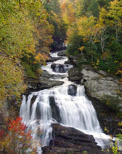
Cullasaja Falls

Cullasaja Falls
Cullasaja Falls
Cullasaja.jpg
Cullasaja Falls in the fall
Location Macon County, North Carolina
Coordinates 35°06′59″N 83°16′10″W / 35.116397°N 83.269527°W / 35.116397; -83.269527
Type Cascade
Total height 200 ft (61.0 m) - Disputed (see Geology Section)

Cullasaja Falls is a waterfall in Southwestern North Carolina. The waterfall is located on the Cullasaja River in the Nantahala National Forest and is part of the Mountain Waters Scenic Byway. Cullasaja comes from a Cherokee word meaning "honey locust place."

Contents

Geology

The falls is the last major waterfall on the Cullasaja River.[1] The falls is a long cascade over the course of 0.2 miles (.3 km).

The height of the falls is given as 200 ft (61 m) in Kevin Adams' book, North Carolina Waterfalls[1] and 250 ft (77.1 m) by NCWaterfalls.com.[2] However, Google Earth gives a height (based on the elevation of the water at the top of the falls and the elevation of the plunge pool at the bottom of the falls) of 137 ft (42 m).

Visiting the Falls

It is easy to catch a glimpse of the falls as you drive by; however, getting a better view of the falls is not easy. The falls are located beside of a series of blind curves on Highway 64 with sheer rock cliffs above and below the road. There is only one small pull-off near the falls, but walking on the road puts visitors in danger of being hit by a passing vehicle.

Activities

Though difficult to to reach, some use the falls as a place for leisure activities such as swimming (in the pool below) or rappelling.

Cullasaja Falls during a period of very high flow

Nearby Falls

References

  1. ^ a b Adams, Kevin (2005). North Carolina Waterfalls. John F. Blair. p. 470. ISBN 0895873206. 
  2. ^ NCWaterfalls.com

External links


Wikimedia Foundation. 2010.

Игры ⚽ Нужно решить контрольную?

Look at other dictionaries:

  • Cullasaja River — The Cullasaja River is a short river located entirely in Macon County, North Carolina. It is a tributary of the Little Tennessee River (and in turn the Tennessee River, Ohio River and Mississippi River), into which it flows near the county seat… …   Wikipedia

  • Dry Falls (North Carolina) — For the Dry Falls of Washington State, see Dry Falls. Dry Falls Dry Falls, Aug 2009 Location Nantahala National Forest, Macon County, in the Blue Ridge Mountains of North Carolina …   Wikipedia

  • Bridal Veil Falls (Macon County) — Infobox Waterfall caption=Bridal Veil Falls, Aug 2006 name=Bridal Veil Falls location=Nantahala National Forest, Macon County, in the Blue Ridge Mountains of North Carolina type=Slide, Plunge height=Convert|45|ft|m|1|abbr=on height… …   Wikipedia

  • Quarry Falls (Macon County) — Quarry Falls is a small waterfall (or perhaps large rapid in high water) located beside US Hwy. 64 west of Highlands, North Carolina. It is best known for the large, deep pool at the bottom and is a popular place for swimming during warm… …   Wikipedia

  • Highlands, North Carolina — Infobox Settlement official name = Highlands, North Carolina settlement type = Town nickname = Elevation 4118 motto = Above it all [ [http://www.highlandschamber.org/ Highlands Chamber of Commerce website] ] imagesize = 250px image caption = The… …   Wikipedia

  • Liste de chutes d'eau — Cette liste est incomplète ou mal ordonnée. Votre aide est la bienvenue ! Salto Angel, la plus haute chute du monde, Venezuela Ceci est une liste des chutes d ea …   Wikipédia en Français

  • Mountain Waters Scenic Byway — The Mountain Waters Scenic Byway is a two lane highway in North Carolina, which travels through the Nantahala National Forest in Macon and Swain County, North Carolina counties. The first part of this 61.3 mile (98.7 km) byway follows the… …   Wikipedia

  • List of waterfalls — This is a list of waterfalls of the world by continent.AfricaAngola*Kalandula Falls, second largest in AfricaBurkina Faso*Tagbaladougou FallsDemocratic Republic of the Congo*Boyoma Falls (Stanley Falls) *Inga Falls *Livingstone Falls *Lofoi… …   Wikipedia

  • Waterfalls of North Carolina — The waterfalls of North Carolina, U.S.A., are a prominent feature of the geography of the piedmont and mountain regions of the state, as well as a major focus of tourism and outdoor recreation. Many of these falls are located in state parks,… …   Wikipedia

  • Nantahala National Forest — Coordinates: 35°14′02″N 83°33′33″W / 35.233842°N 83.559265°W / 35.233842; 83.559265 …   Wikipedia

Share the article and excerpts

Direct link
Do a right-click on the link above
and select “Copy Link”