Drybridge railway station

Drybridge railway station
Drybridge
Drybridge railway station.jpg
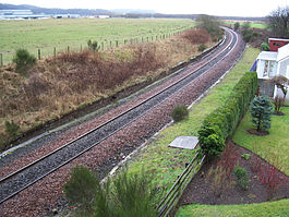
Drybridge station in early 2006
Location
Place Drybridge
Area Ayrshire
Coordinates 55°35′38″N 4°36′13″W / 55.5940°N 4.6037°W / 55.5940; -4.6037Coordinates: 55°35′38″N 4°36′13″W / 55.5940°N 4.6037°W / 55.5940; -4.6037
Grid reference NS359364
Operations
Original company Kilmarnock and Troon Railway
Pre-grouping Glasgow and South Western Railway
Platforms 2
History
6 July 1812 Opened[1]
3 March 1969 Closed[1]
Disused railway stations in the United Kingdom
Closed railway stations in Britain
A B C D–F G H–J K–L M–O P–R S T–V W–Z
Portal icon UK Railways portal

Drybridge railway station was a railway station serving the village of Drybridge, North Ayrshire, Scotland.

Contents

History

The station was opened on 6 July 1812 by the Kilmarnock and Troon Railway.[1] The Glasgow, Paisley, Kilmarnock and Ayr Railway took over management of the station on 16 July 1846,[2] while its successor, the Glasgow and South Western Railway, took over full ownership in 1899.[3] The station closed on 3 March 1969.[1]

Today Drybridge station has its platforms intact (although overgrown), and the station building is now a private residence. The line is still open as part of the Glasgow South Western Line.

The village of 'Drybridge' is so named after the fact that most bridges up until the era of the railways were built over watercourses and were therefore 'wet bridges'; a name applied to the nearby Laigh Milton Viaduct.

Visible from the station is the only surviving standing stone on the mainland in North Ayrshire.

References

Notes

  1. ^ a b c d Butt (1995), page 83
  2. ^ Awdry, p. 84
  3. ^ Stansfield, p. 8

Sources

  • Awdry, Christopher (1990). Encyclopaedia of British Railway Companies. Sparkford: Patrick Stephens Ltd. ISBN 1-8526-0049-7. OCLC 19514063. 
  • Butt, R. V. J. (1995). The Directory of Railway Stations: details every public and private passenger station, halt, platform and stopping place, past and present (1st ed.). Sparkford: Patrick Stephens Ltd. ISBN 1-8526-0508-1. OCLC 60251199. 
  • Stansfield, G. (1999). Ayrshire & Renfrewshire's Lost Railways. Ochiltree: Stenlake Publishing. ISBN 1-8403-3077-5. 


Preceding station Historical railways Following station
Barassie
Line and station open
  Glasgow and South Western Railway

Kilmarnock and Troon Railway

  Gatehead
Line open; station closed

Wikimedia Foundation. 2010.

Игры ⚽ Нужен реферат?

Look at other dictionaries:

  • Gatehead railway station — Infobox UK disused station name = Gatehead caption = The remains of the station platform in early 2007 line = Kilmarnock and Troon Railway manager = Glasgow and South Western Railway locale = Gatehead borough = Ayrshire latitude = 55.5943… …   Wikipedia

  • Barassie railway station — Infobox UK station name = Barassie code = BSS manager = First ScotRail pte = SPT locale = Barassie borough = South Ayrshire latitude = 55.5606 longitude = 4.6507 gridref = NS328328 platforms = 2 years = 5 August 1839 events = Opened lowusage0405 …   Wikipedia

  • Drybridge — is a village in North Ayrshire, Scotland. Drybridge is thus named because of the dry bridge over the Kilmarnock and Troon Railway, opened in 1812. The nearby wet bridge is the Laigh Milton Viaduct, the oldest surviving railway bridge in the world …   Wikipedia

  • Kilmarnock and Troon Railway — The Kilmarnock and Troon Railway was the first railway line in Scotland authorised by Act of Parliament, in 1808; the engineer was William Jessop.Lewin (1925), Page 5] Awdry (1990), Page 84] Robertson (1983)] It was the first railway in Scotland… …   Wikipedia

  • Laigh Milton Viaduct — Infobox Bridge bridge name = Laigh Milton Viaduct caption = Laigh Milton Viaduct in East Ayrshire over the River Irvine official name = Laigh Milton Viaduct locale = Laigh Milton mill at Gatehead in East Ayrshire, Scotland. carries = Traffic… …   Wikipedia

  • Dalry, North Ayrshire — Coordinates: 55°42′40″N 4°43′23″W / 55.711°N 4.723°W / 55.711; 4.723 …   Wikipedia

  • Cunninghamhead, Perceton and Annick Lodge — Coordinates: 55°38′35″N 4°34′52″W / 55.643°N 4.581°W / 55.643; 4.581 Cunninghamhead is a hamlet i …   Wikipedia

  • Montgreenan — is an estate in North Ayrshire, Parish of Kilwinning, Scotland. The Lugton Water runs through the policies and farmland of Montgreenan. Nearby are the hamlets of Torranyard and Auchentiber. Montgreenan House Contents …   Wikipedia

  • Gatehead, East Ayrshire — Infobox UK place official name= Gatehead gaelic name= scots name= local name= country= Scotland map type= Scotland population= population density= os grid reference= NS393364 edinburgh distance= london distance= latitude= 55.5955 longitude=… …   Wikipedia

  • Ayrshire — This article is about the region in Scotland. For the cattle originating from Ayrshire, see Ayrshire cattle. For the small city in the United States, see Ayrshire, Iowa. Ayr   County (until circa 1890)   …   Wikipedia

Share the article and excerpts

Direct link
Do a right-click on the link above
and select “Copy Link”