- Pingualuit crater
-
Crater characteristics 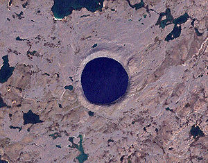
Pingualuit CraterPlanet Earth Coordinates 61°16′30″N 73°39′37″W / 61.274997°N 73.660278°WCoordinates: 61°16′30″N 73°39′37″W / 61.274997°N 73.660278°W Diameter 3.44 km (2.14 mi) Depth 400 m (1,300 ft) Discoverer Frederick W. Chubb 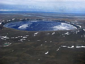

The Pingualuit Crater (French: cratère des Pingualuit; Inuktitut, "where the land rises"), formerly called Chubb Crater and later New Quebec Crater (cratère du Nouveau-Québec), is a young impact crater, by geological standards, located in the Ungava Peninsula of Quebec, Canada. It is 3.44 km (2.14 mi) in diameter, and is estimated to be 1.4 ± 0.1 million years old (Pleistocene).[1]
The crater is exposed to the surface, rising 160 m (520 ft) above the surrounding tundra and is 400 m (1,300 ft) deep. A 252 m (827 ft) deep Pingualuk Lake fills the depression, and is one of the deepest lakes in North America. The lake also holds some of the purest fresh water in the world, with a salinity level of less than 3 ppm (the salinity level of the Great Lakes is 500 ppm). The lake has no inlets or apparent outlets, so the water accumulates solely from rain and snow and is only lost through evaporation. In terms of transparency, it is second only to Lake Mashū in Japan.
Contents
Discovery
Largely unknown to the outside world, the lake-filled crater had long been known to local Inuit who knew it as the "Crystal Eye of Nunavik" for its clear water. World War II pilots often used the perfectly circular landmark as a navigational tool.[2]
On June 20, 1943, a United States Army Air Force plane on a meteorological flight over the Ungava region of Quebec Province took a photograph which showed the wide crater rim rising up above the landscape. In 1948 the Royal Canadian Air Force covered the same remote area as part of its program of photomapping Canada, however these photographs were not made publicly available until 1950.
In 1950 Ontario diamond prospector Frederick W. Chubb became interested by the strange terrain shown in the photographs and sought the opinion of geologist V. Ben Meen of the Royal Ontario Museum. Chubb hoped that the crater was that of an extinct volcano, in which case the area might contain diamond deposits similar to those of South Africa. However, Meen's knowledge of Canadian geology tentatively ruled out a volcanic origin. Meen subsequently made a brief trip by air to the crater with Chubb in 1950; it was on this trip that Meen proposed the name "Chubb Crater" for the circular feature and "Museum Lake" for the irregular body of water about 2 mi (3.2 km) north of the crater (curr. Laflamme Lake).
Following his return, Meen organized a proper expedition with the cooperation of the National Geographic Society and the Royal Ontario Museum, which travelled to the site in a PBY Catalina flying boat in July 1951, which enabled them to land on nearby Museum Lake.[3] Attempts to find fragments of nickel-iron from the meteorite using mine detectors loaned by the US Army were unsuccessful, due to the area's granite containing high levels of magnetite. However, a magnetometer survey found a magnetic anomaly under the crater's northern rim, indicating that a large mass of metal-bearing material was buried below the surface.[4]
Meen led a second expedition to the crater in 1954. That same year its name was changed to "Cratère du Nouveau-Quebec" ("New Quebec Crater") at the request of the Quebec Geographic Board. In 1999, the name was again changed, to "Pingualuit". The crater and the surrounding area are now part of Pingualuit National Park.
2007 expedition
Professor Reinhard Pienitz of Laval University led a 2007 expedition to the crater which extracted sediment cores from the bottom of the lake which were filled with fossil pollen, algae, and insect larvae. It was hoped that these finds would yield information about climate change dating back to the last interglacial period 120,000 years ago.[2]
References
- ^ "New Quebec". Earth Impact Database. University of New Brunswick. http://www.passc.net/EarthImpactDatabase/new-quebec.html. Retrieved 2009-08-16.
- ^ a b Peritz, Ingrid (25 May 2007). "Quebec crater is out of this world". The Globe and Mail. http://six.pairlist.net/pipermail/meteorite-list/2007-May/035188.html. Retrieved 2008-08-17.
- ^ Meen, V. Ben (January 1952). "Solving the Riddle of Chubb Crater". National Geographic Magazine CI (1)
- ^ "Buried Missile". TIME. 24 September 1951. http://www.time.com/time/magazine/article/0,9171,821723,00.html
External links
- Globe and Mail article about the crater
- Nunavik (Québec) tourism site
- Pingualuit National Park (1)
- Pingualuit National Park (2)
- Earth Impact Database, New Quebec details
- Aerial Exploration of the Pingualuit (New Quebec) Structure
Categories:- Earth Impact Database
- Impact craters of Quebec
- Pleistocene impact craters


Wikimedia Foundation. 2010.