- Tehachapi Mountains
Geobox|Range
name=Tehachapi Mountains

image_caption=Wind farm east ofTehachapi Pass
country=United States
state = California
region_type = Counties
region=Kern
region1=Los Angeles
region2=
border=Coast Ranges| border1=Sierra Nevada
highest=Double Mountain
highest_elevation_imperial=7981
highest_lat_d=
highest_long_d=
The Tehachapi Mountains (IPAEng|təˈhætʃəˌpi) are a short transverse range in southern
California in theUnited States , running SW-NE connecting theCoast Ranges on the west with the southern end of the Sierra Nevada mountains on the east. The range extends for approximately 40 mi (64 km) SW-NE in southern Kern County southeast of Bakersfield and vary in height from approximately 4,000 ft (1,220 m) to 8,000 ft (2,440 m).Description
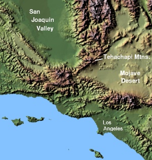
The range forms a barrier separating the
San Joaquin Valley to the northwest and theMojave Desert in theGreat Basin to the southeast. The range is crossed byTejon Pass at its southwestern end (providing the route for Interstate 5). The dramatic incline of Interstate 5 on the northern slopes of this mountain range, downhill to the San Joaquin Valley floor, is regionally referred to as "The Grapevine" because of the grapevines still found on the earlier route on the mountain slope next to the highway. (Sometimes this colloquial name is extended to describe the portion of Interstate 5 on the southern slopes of the mountain range as well, which drops intoSanta Clarita, California and the Los Angeles metro area.)The less geographically dramatic
Tehachapi Pass found on State Route 58 is at its northeastern end. It is also crossed by theCalifornia Aqueduct that supplies water from the Sacramento-San Joaquin Delta to Southern California. TheLos Angeles Aqueduct flows along the southern edge of the mountains. TheTehachapi Loop provides a majorrailroad link across the mountains and is considered an engineering marvel.The Tehachapis, though not a long or high mountain range as California mountain ranges go, are regarded by many Californians as the dividing feature that separates northern California from southern California (though some contend that southern California extends as far north as the Fresno area). Because the
Ridge Route auto highway was constructed across these mountains and the ranges south of it in the early 20th century, many historians say California averted a potential split into two separate states - North California and South California. (There have in fact been two distinct periods of California history where this split has been discussed in the legislature, in 1860 and 1965, and both proposed the crest of the Tehachapi Mountains as the new border. Both proposals, of course, failed.)The Monolith cement works, which supplied cement for the construction of
Hoover Dam , among other major public works, is situated in the Tehachapis east of Tehachapi Pass.Geology
The Tehachapis are largely the result of the movements of the
Garlock Fault ,located along the southern base of the range, a majortransform fault which runs from theSan Andreas Fault in the west to theSierra Fault on the east and some distance beyond. This fault is unusual in California in that it is a left-lateral fault, that is, it's motion is opposite to most of the faults in the state which are right-lateral faults.Climate
The range is in an interesting crossroads among climate zones. The
Great Basin to the east and southeast typically receives just a few inches of precipitation a year, usually in winter. Summermonsoon season can bring localized torrential rains to parts of the range as well. To the south and southwest lie the mainTransverse Ranges in theLos Padres National Forest andAngeles National Forest s. The prevailing wind is southwesterly, funneling throughTejon Pass and into the east-west canyons and valleys of the Tehachapi range with regularity. To the northwest lies theSan Joaquin Valley with itsoak savanna climbing the broad western slopes of the range. Like sand dunes piling up where winds converge, the Tehachapis collect marine and valley moisture, which piles up into fog that blankets the range many weeks of the year. Like Sicily is to Italy, the Tehachapi crest is a subalpine island at the toe of the Sierra Nevada, which dominates the northern skyline. The higher north-facing (subalpine) slopes are mixed conifer and scrub oak, while the south-facing (continental) are live oak, scrub andGray Pine (Pinus sabaniana), typical of the relationship between the moisture-retaining northern slopes and the year-round exposed southern slopes. The area surrounding the Tehachapi Crest is semiarid, including the sage country of the Tehachapi Pass area. Canyons, even on southern slopes, however, can have year-round water flows, particularly whenorographic enhancement has squeezed extra precipitation from passing storms and snowmelt during the spring months.Tehachapi Mountains in pop culture
*The
Reality TV show was filmed in the Tehachapi Mountains at theTejon Ranch
*In the movie "There Will Be Blood ",Daniel Day-Lewis ' character,Daniel Plainview , says to his realtor, "Can I build (an oil pipeline) around fifty miles of Tehachapi Mountains? Don't be thick in front of me Al."Peaks
* Double Mountain 7,981 ft (2,433 m)
*Tehachapi Mountain 7,960+ ft (2,426+ m)
*Cummings Mountain 7,760+ ft (2,365+ m)
* Bear Mountain 6,920+ ft (2,109+ m)
* Black Mountain 5,686 ft (1,733 m)
*Grapevine Peak 4,815 ft (1,468 m)ee also
*
Edmonston Pumping Plant
*San Emigdio Mountains
*Sierra Pelona Mountains
*Temblor Range - the other side ofSan Joaquin Valley
Wikimedia Foundation. 2010.