- City Hall (IRT Lexington Avenue Line)
-
For the IRT Lexington Avenue Line station currently known as City Hall, see Brooklyn Bridge – City Hall (IRT Lexington Avenue Line).
City Hall New York City Subway rapid transit station 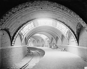
Station statistics Address Park Row and City Hall Park
New York, NYBorough Manhattan Locale Civic Center Coordinates 40°42′48″N 74°00′24″W / 40.71326°N 74.00671°WCoordinates: 40°42′48″N 74°00′24″W / 40.71326°N 74.00671°W Line IRT Lexington Avenue Line Services  None (track is used to turn 6
  <6>
<6> trains)
Structure Underground Platforms 1 side platform Tracks 1 balloon loop Other information Opened October 27, 1904[1] Closed December 31, 1945[2] Station succession Next north Brooklyn Bridge – City Hall Next south (Terminal) City Hall Subway Station (IRT)[3]

Location: New York City, New York Coordinates: 40°42′48″N 74°00′24″W / 40.71326°N 74.00671°WCoordinates: 40°42′48″N 74°00′24″W / 40.71326°N 74.00671°W Built: 1904 Architect: Heins & LaFarge Architectural style: Romanesque Revival Governing body: Metropolitan Transportation Authority MPS: New York City Subway System MPS NRHP Reference#: 04001010 Added to NRHP: September 17, 2004 City Hall, also known as City Hall Loop,[4] was the original southern terminal station of the first line of the New York City Subway, built by the Interborough Rapid Transit Company (IRT), named the "Manhattan Main Line", and now part of the IRT Lexington Avenue Line. Opened on October 27, 1904,[1] this station underneath the public area in front of City Hall was designed to be the showpiece of the new subway. The station was designed by Rafael Guastavino.[5] The main consulting architects on the IRT stations were George Lewis Heins and Christopher Grant LaFarge for the company Heins & LaFarge.[6] This station is unusually elegant in architectural style, and is unique among the original IRT stations, employing Romanesque Revival architecture.[7] The platform and mezzanine feature Guastavino tile, skylights, colored glass tilework and brass chandeliers. Passenger service was discontinued on December 31, 1945,[2] making it a ghost station, although the station is still used as a turning loop for 6 and <6> trains.
Contents
History
Construction
The official start of construction took place on 24 March 1900 at the front steps of City Hall, at a ceremony officiated by then Mayor Robert Van Wyck.[8]
Unlike the rest of the subway line, City Hall station had tall tile arches, brass fixtures, chandeliers, skylights, polychrome tile, and elegant curves that ran along the platform. It was lit by wrought iron chandeliers and the three skylights of cut amethyst glass[9] that allowed sunshine onto parts of the platform. During World War II, the skylights were blacked out with tar for safety.
After construction was complete, this station was the chosen place for hanging commemorative plaques recognizing the achievement of building the entire New York underground train system. Built before tokens were used by the subway system, a mezzanine area above the platform once had an ornamented oak ticket booth (which no longer exists).[6]
Opening day
The subway opened to the public October 28, 1904, after opening ceremonies the day before attended by Mayor George McClellan.[10][11]
More than 15,000 people were issued passes for the first series of rides from the platform. At precisely 2:35 pm, the first subway train departed from City Hall station with Mayor McClellan at the controls. The event was so heavily attended that police Commissioner McAdoo said every policeman in the city was on duty all day and far into the night.[12]
At the time of the opening, President A. E. Orr of the Rapid Transit Board requested that all New Yorkers join in the celebration by the blowing whistles and ringing bells.[13] At street level, in the pavement in front of City Hall, a plaque can still be seen commemorating groundbreaking for the subway in 1900.[14]
Closure
In the years after the line's construction, increased subway ridership led to longer trains, and thus longer platforms, in the 1940s and early 1950s. City Hall station, built on a tight curve, would have been difficult to lengthen, and it was also quite close to the far busier Brooklyn Bridge station.
In addition, the new, longer trains had center doors in each car, which were an unsafe distance from the platform edge. At the South Ferry and 14th Street – Union Square stations, which had a similar problem, movable platform extensions were installed to fill the gap.
City Hall, notwithstanding its architectural grandeur, was never an important station. In its final year of use, it served only 600 passengers per day and was not open at nights (when trains continued to the loop station at South Ferry). The Brooklyn Bridge station, located a short walk away, at the opposite end of City Hall Park, was more popular, as it provided both local and express service, including trains to Brooklyn. The Brooklyn Bridge streetcar terminal and Park Row station on the BMT elevated lines were above for easy transfers.
Given the extensive renovations that would have been required to bring the station up to modern standards, the city decided to close it instead. The final day of service was December 31, 1945.
Track configuration
City Hall station track layout LegendIRT Lexington Avenue Line continues north 

Brooklyn Bridge – City Hall 


abandoned platform 


storage tracks 

IRT Lexington Avenue Line continues south North of City Hall station, the IRT Lexington Avenue Line carries four tracks. As seen in the diagram, left to right, these are the downtown local track, the downtown express track, the uptown express track, and the uptown local track.
South of the Brooklyn Bridge station, there is a switch on the downtown local track, allowing trains to leave service and enter either of two storage tracks. Trains in service turn onto a balloon loop, continuing past the abandoned side platform on the west side of the loop, and re-appearing in the Brooklyn Bridge station on the uptown local track. The uptown and downtown express tracks pass over the loop, continuing south.
Current status
In April 1995, federal grant money was sought to reopen the station as a branch of the New York Transit Museum, which occasionally ran tours of the station as part of its popular "Day 1 of the IRT" and "Beneath City Hall" packages. In late 1998, due to perceived security risks in the area around City Hall after terrorist bombings in Nairobi and Dar es Salaam, the station was declared a "highly secure" area by the Giuliani administration. Plans for the museum annex were abandoned and museum tours ceased for several years.
On the surface, all that can be seen is a concrete slab inset with glass tiles, the skylights for the platform below. This patch of concrete is in the middle of a grove of dogwoods in front of City Hall, close to Broadway.
For the 2004 Centennial Celebration, one of the street entrances was restored (and presently resembles a modern station entrance), and the station was opened for the duration of the celebration. Otherwise, the station is now used only as an emergency exit.
As of 2006, tours of the station are once again being conducted,[15] by the staff of the Transit Museum.[16] However, at present, tours are only open to registered members of the museum and require advance payment and reservations.
The station can also be seen by passengers who remain on the downtown 6 <6> trains as they travel around the loop to head back uptown. The loop track is classified as revenue track, and the newest announcement programs on the R142A subway cars announce at Brooklyn Bridge: "This is the last downtown stop on this train. The next stop will be Brooklyn Bridge – City Hall on the uptown platform." A further announcement follows, warning passengers to remain inside the car at all times.[17]
Gallery
-

Early postcard (1913?)
-

Plan of the station
See also
References
- ^ a b "Our Subway Open, 150,000 People Try It" (PDF). The New York Times: p. 1. October 28, 1904. http://query.nytimes.com/mem/archive-free/pdf?_r=1&res=9E06EFD71230EE32A2575BC2A9669D946597D6CF. Retrieved 2009-11-15.
- ^ a b "Historic Station Closed After 41 Years". The New York Times: p. 22. January 1, 1946. http://select.nytimes.com/gst/abstract.html?res=FB0715F63D5D107A93C3A9178AD85F428485F9. Retrieved 2010-05-30.
- ^ "National Register of Historic Places Listings". National Park Service. October 1, 2004. http://www.nps.gov/nr/listings/20041001.htm. Retrieved 2009-03-05.
- ^ Interborough Rapid Transit Company (1904). Map and Profile of Railway (Map). http://nycsubway.org/perl/caption.pl?/img/articles/souvenir-mapprofile.jpg. Retrieved 2008-09-15.
- ^ David W. Dunlap (May 1, 2011). "The City's Curves, on Display or Hidden Away". The New York Times: p. 36.
- ^ a b http://untappednewyork.com/2010/09/26/the-old-city-hall-station/
- ^ Brooks, Michael W. (1997). Subway city: riding the trains, reading New York. New Brunswick, New Jersey: Rutgers University Press. p. 66. ISBN 0-8135-2396-6.
- ^ http://www.columbia.edu/~brennan/abandoned/cityirt.html
- ^ http://www.puppiesandflowers.com/archives/2009/04/new_york_city_subway_the_defun.html
- ^ http://jalopnik.com/5684329/how-to-see-new-yorks-secret-city-hall-subway-stop
- ^ http://www.forgotten-ny.com/SUBWAYS/City%20Hall%20Station/cityhall.html
- ^ http://www.nycsubway.org/articles/nytimes-1904-openingtoday.html
- ^ http://www.nycsubway.org/articles/nytimes-1904-finishplans.html
- ^ http://the-tech.mit.edu/~Subway/Archives/CityHall/CityHall1.html
- ^ "Living for the City". Forgotten NY. http://www.forgotten-ny.com/SUBWAYS/newcityhall/newcityhall.html. Retrieved 2009-11-15.
- ^ New York City Transit Museum programs
- ^ Cuza, Bobby (March 6, 2007). "See A Glimpse Of NYC History For The Price Of A Subway Ride". NY1. http://ny1.com/1-all-boroughs-news-content/top_stories/?SecID=1000&ArID=67432. Retrieved 2009-11-15.
Further reading
- Lee Stokey. Subway Ceramics : A History and Iconography. 1994. ISBN 978-0963548610
External links
- nycsubway.org — IRT East Side Line: City Hall
- Abandoned Stations — City Hall (IRT)
- The IRT First Stations — City Hall
- Forgotten NY — Original 28 – NYC's First 28 Subway Stations
Categories:- IRT Lexington Avenue Line stations
- Defunct New York City Subway stations
- Railway and subway stations on the National Register of Historic Places in Manhattan
- Railway stations opened in 1904
- Railway stations closed in 1945
-


Wikimedia Foundation. 2010.