- Mahon River Light
-
Mahon River Light 
Port Mahon Lighthouse Location Port Mahon, Delaware Year first constructed 1903 Deactivated 1955 Construction Steel skeletal tower Tower shape Skeletal tower Original lens Fresnel lens Characteristic white flash every 4 s ARLHS number USA-464 Port Mahon Lighthouse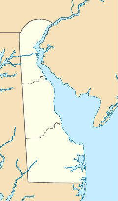

Nearest city: Little Creek, Delaware Coordinates: 39°11′5″N 75°24′4″W / 39.18472°N 75.40111°WCoordinates: 39°11′5″N 75°24′4″W / 39.18472°N 75.40111°W Built: 1902 Governing body: AIR FORCE NRHP Reference#: 79000624[1] Added to NRHP: October 25, 1979 Mahon River Lighthouse is a U.S. lighthouse in Port Mahon, Delaware, on the west side of the mouth of the Delaware River.
History
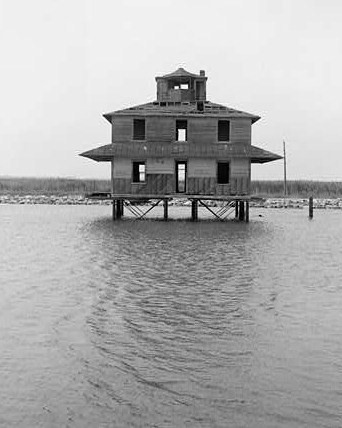
The original Mahon River Lighthouse built in 1903 and was a 2-story wood keeper's house with an octagonal lantern centered on the roof. It was discontinued in 1955, the same year as the current steel skeletal tower was lit. The 1903 lighthouse burned accidentally in 1984. The clubhouse of the Jonathan's Landing Golf Course in Magnolia was built as a replica of the original lighthouse. The current tower is an active aid to navigation and not open to the public.
References
- ^ "National Register Information System". National Register of Historic Places. National Park Service. 2009-03-13. http://nrhp.focus.nps.gov/natreg/docs/All_Data.html.
U.S. National Register of Historic Places Topics Lists by states Alabama • Alaska • Arizona • Arkansas • California • Colorado • Connecticut • Delaware • Florida • Georgia • Hawaii • Idaho • Illinois • Indiana • Iowa • Kansas • Kentucky • Louisiana • Maine • Maryland • Massachusetts • Michigan • Minnesota • Mississippi • Missouri • Montana • Nebraska • Nevada • New Hampshire • New Jersey • New Mexico • New York • North Carolina • North Dakota • Ohio • Oklahoma • Oregon • Pennsylvania • Rhode Island • South Carolina • South Dakota • Tennessee • Texas • Utah • Vermont • Virginia • Washington • West Virginia • Wisconsin • WyomingLists by territories Lists by associated states Other  Category:National Register of Historic Places •
  Portal:National Register of Historic Places
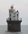
U.S. National Register of Historic Places Topics Lists by states Alabama • Alaska • Arizona • Arkansas • California • Colorado • Connecticut • Delaware • Florida • Georgia • Hawaii • Idaho • Illinois • Indiana • Iowa • Kansas • Kentucky • Louisiana • Maine • Maryland • Massachusetts • Michigan • Minnesota • Mississippi • Missouri • Montana • Nebraska • Nevada • New Hampshire • New Jersey • New Mexico • New York • North Carolina • North Dakota • Ohio • Oklahoma • Oregon • Pennsylvania • Rhode Island • South Carolina • South Dakota • Tennessee • Texas • Utah • Vermont • Virginia • Washington • West Virginia • Wisconsin • WyomingLists by territories Lists by associated states Other Category:National Register of Historic Places • Portal:National Register of Historic PlacesCategories:- Lighthouses on the National Register of Historic Places in Delaware
- Buildings and structures in Kent County, Delaware
- Transportation in Kent County, Delaware
- United States lighthouse stubs
- Northeastern United States building and structure stubs
- Delaware stubs


Wikimedia Foundation. 2010.