- Strait of Malacca
-
 The Strait of Malacca connects the Pacific Ocean to the east with the Indian Ocean to the west.
Coordinates: 4°N 100°E / 4°N 100°E The Strait of Malacca is a narrow, 805 km (500 mi) stretch of water between the Malay Peninsula (Peninsular Malaysia) and the Indonesian island of Sumatra. It is named after the Malacca Sultanate that ruled over the archipelago between 1414 to 1511.
Contents
Extent
The International Hydrographic Organization defines the limits of the "Malacca Strait" as follows:[1]
On the West. A line joining Pedropunt, the Northernmost point of Sumatra (5°40′N 95°26′E / 5.667°N 95.433°E) and Lem Voalan the Southern extremity of Goh Puket [Phuket Island] in Siam [Thailand] (7°45′N 98°18′E / 7.75°N 98.3°E).
On the East. A line joining Tanjong Piai (Bulus), the Southern extremity of the Malay Peninsula (1°16′N 103°31′E / 1.267°N 103.517°E) and The Brothers (1°11.5′N 103°21′E / 1.1917°N 103.35°E) and thence to Klein Karimoen (1°10′N 103°23.5′E / 1.167°N 103.3917°E).
On the North. The Southwestern coast of the Malay Peninsula.
On the South. The Northeastern coast of Sumatra as far to the eastward as Tanjong Kedabu (1°06′N 102°58′E / 1.1°N 102.967°E) thence to Klein Karimoen.
Economic importance
From an economic and strategic perspective, the Strait of Malacca is one of the most important shipping lanes in the world.
The strait is the main shipping channel between the Indian Ocean and the Pacific Ocean, linking major Asian economies such as India, China, Japan and South Korea. Over 50,000 (94,000?)[2] vessels pass through the strait per year,[3] carrying about one-quarter of the world's traded goods including oil, Chinese manufactures, and Indonesian coffee.[4]
About a quarter of all oil carried by sea passes through the strait, mainly from Persian Gulf suppliers to Asian markets such as China, Japan, and South Korea. In 2006, an estimated 15 million barrels per day (2,400,000 m3/d) were transported through the strait.[5]
The maximum size of a vessel that can make passage through the Strait is referred to as Malaccamax. The strait is not deep enough (at 25 metres or 82 feet) to permit some of the largest ships (mostly oil tankers) to use it. A ship that exceeds Malaccamax will typically use the Lombok Strait, Makassar Strait, Sibutu Passage and Mindoro Strait instead.
At Phillips Channel close to the south of Singapore, the Strait of Malacca narrows to 2.8 km (1.5 nautical miles) wide, creating one of the world's most significant traffic choke points.[6]
Shipping hazards
See also: Piracy in the Strait of MalaccaPiracy in the strait has risen in recent years. There were about 25 attacks on vessels in 1994, 220 in 2000, and just over 150 in 2003 (one-third of the global total).[citation needed] After attacks rose again in the first half of 2004, the Malaysian, Indonesian and Singaporean navies stepped up their patrols of the area in July 2004. Subsequently, attacks on ships in the Strait of Malacca dropped, to 79 in 2005 and 50 in 2006.[7]
There are 34 shipwrecks, some dating to the 1880s, in the Traffic Separation Scheme (TSS), the channel for commercial ships. These pose a collision hazard in the narrow and shallow Strait.[8]
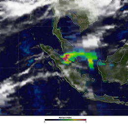 Yearly haze from the smoke of raging bush fires, limiting visibility.
Another risk is the yearly haze caused by raging bush fires in Sumatra. It can reduce visibility to 200 metres (660 ft), forcing ships to slow down in the busy strait. Ships longer than 350 metres (1,150 ft) routinely use the strait.[citation needed]
Proposals to relieve the strait
Thailand has developed several plans to diminish the economic significance of the strait. The Thai government has over the course of its history several times proposed to cut a canal through the Isthmus of Kra, saving around 960 kilometres (600 mi) from the journey from the Indian Ocean to the Pacific. This would also cut Thailand in two, further isolating the separatist Muslim majority in Pattani. China has offered to cover the costs, according to a report leaked to The Washington Times in 2004. Nevertheless, and despite the support of several Thai politicians, the prohibitive financial and ecological costs suggest that no such canal will go ahead.
A second alternative is to build a pipeline across the Isthmus of Kra to carry oil to ships waiting on the other side. Proponents say it would cut the cost of oil delivery to Asia by about $0.50/barrel ($3/m3). Burma has also made a similar pipeline proposal.
History

Early traders from Arabia, Africa, Persia, and Southern Indian kingdoms used to reach Kedah before arriving at Guangzhou. They traded glassware, camphor, cotton goods, brocades, ivory, sandalwood, perfumes and precious stones. Kedah served as a western port on the Malay Peninsula. These traders sailed to Kedah via the monsoon winds between June and November. They returned between December and May. Kedah provided accommodations, porters, small vessels, bamboo rafts, elephants, and also tax collections for goods to be transported overland toward the eastern ports of the Malay Peninsula such as Langkasuka and Kelantan. Ships from China came to trade at these eastern trading posts and ports. Kedah and Funan were famous ports through the 6th century, before shipping began to utilize the Strait of Malacca itself as a trade route.
In 7th century the maritime empire of Srivijaya based on Palembang, Sumatra, rose to power, and its influence expands to the Malay peninsula and Java. The empire gained effective control on two major choke points in maritime Southeast Asia; Malaccan strait and Sunda Strait. By launching series of conquests and raids on potentially rival ports on both side of the strait, Srivijaya ensure its economic and military domination in the region lasted for about 700 years. Srivijaya gain benefit from lucrative spice trade, tributary trade system with China, and trade with Indian and Arab merchants. Malacca strait become the important maritime trade route between India and China. The importance of Malacca strait in global trade networks continued well into centuries later with the rise of Malacca Sultanate in 15th century, Riau-Johor Sultanate, and followed by modern Singapore.
See also
- Early history of Kedah
- Malacca Town
- Mangroves of the Straits of Malacca
- Sultanate of Kedah
References
- ^ "Limits of Oceans and Seas, 3rd edition". International Hydrographic Organization. 1953. http://www.iho-ohi.net/iho_pubs/standard/S-23/S23_1953.pdf. Retrieved 7 February 2010.
- ^ Aljazeera.net (English)
- ^ Strait of Malacca - World Oil Transit Chokepoints, Energy Informatin Administration, U.S. Department of Energy
- ^ Freeman, Donald B. (2003). The Straits of Malacca: Gateway or Gauntlet?. McGill-Queen's University Press. ISBN 0773525157.. A book review citing this information can be found at University of Toronto Quarterly, Volume 74, Number 1, Winter 2004/5, pp. 528-530
- ^ World Oil Transit Chokepoints, Energy Information Administration, US Department of Energy
- ^ World Oil Transit Chokepoints
- ^ Piracy down 3rd year in row: IMB report", Journal of Commerce Online; January 23, 2007.
- ^ 34 wrecks in sealane threaten passing ships
External links
- World oil transit chokepoints
- Maritime Security in Southeast Asia: U.S., Japanese, Regional, and Industry Strategies (National Bureau of Asian Research, November 2010)
- BBC News report on the increased security in the Straits
- "Going for the jugular" Report on the potential terrorist threat to the Straits. From the Economist, requires subscription, in the print edition June 10, 2004
- China builds up strategic sea lanes
- A report from the International Maritime Organisation on the implementation of a Straits "Marine Electronic Highway" - a series of technological measures to ensure safe and efficient use of the busy waters
- Malacca, Singapore, and Indonesia (1978) by Michael Leifer
- The Malacca Straits Research and Development Centre homepage
- Al-Jazeera: Malacca Strait nations plan air patrol
- Waterway To the World The Strategic Importance of the Straits of Malacca
- The Strategic Importance of the Straits of Malacca for World Trade and Regional Development
- AP: Singapore warns of terror threat in Malacca Strait, 2010-03-04
Sea Strait - Alas Strait
- Alor Strait
- Badung Strait
- Bali Strait
- Bangka Strait
- Berhala Strait
- Dampier Strait
- Gaspar Strait
- Karimata Strait
- Laut Strait
- Lombok Strait
- Madura Strait
- Makassar Strait
- Malacca Strait
- Mentawai Strait
- Ombai Strait
- Riau Strait
- Rupat Strait
- Sape Strait
- Selayar Strait
- Singapore Strait
- Sumba Strait
- Sunda Strait
- Torres Strait
- Wetar Strait
Gulf - Balikpapan Gulf
- Bintuni Gulf
- Gulf of Boni
- Cenderawasih Gulf
- Jakarta Bay
- Lampung Gulf
- Pelabuhanratu Gulf
- Saleh Gulf
- Semangka Gulf
- Tolo Gulf
- Tomini Gulf
Categories:- Strait of Malacca
- Geography of Southeast Asia
- Straits of Indonesia
- Straits of Malaysia
- Indonesia–Malaysia border
- International straits
- Nature sites of Selangor
- Indonesia–Thailand border


Wikimedia Foundation. 2010.