- Dungarvan
-
Dungarvan
Dún Garbháin— Town — 

Coat of armsMotto: Ni Maraide Go Stiurtoir
Not a Mariner Till a SteersmanLocation in Ireland
 Dungarvan
Coordinates: 52°05′04″N 7°38′23″W / 52.0845°N 7.6397°WCoordinates: 52°05′04″N 7°38′23″W / 52.0845°N 7.6397°W Country Ireland Province Munster County Waterford Elevation 1 m (3 ft) Population (2006)[1] – Urban 7,813 – Environs 549 Irish Grid Reference X259930 Website waterfordcoco.ie Historical populations Year Pop. ±% 1813 4,930 — 1821 5,105 +3.5% 1831 6,527 +27.9% 1841 8,625 +32.1% 1851 6,865 −20.4% 1861 5,886 −14.3% 1871 6,520 +10.8% 1881 6,306 −3.3% 1891 5,263 −16.5% 1901 4,850 −7.8% 1911 4,977 +2.6% 1926 5,207 +4.6% 1936 5,361 +3.0% 1946 5,276 −1.6% 1951 5,423 +2.8% 1956 5,394 −0.5% 1961 5,188 −3.8% 1966 5,380 +3.7% 1971 5,583 +3.8% 1981 6,631 +18.8% 1986 6,849 +3.3% 1991 6,920 +1.0% 1996 7,175 +3.7% 2002 7,452 +3.9% 2006 8,362 +12.2% [2] Dungarvan (Irish: Dún Garbháin) is a town and harbour on the south coast of Ireland in the province of Munster. Dungarvan is the county town and administrative centre of County Waterford.[3] The town's Irish name means "Garbhan's fort", referring to Saint Garbhan who founded a church there in the seventh century. The town lies on the N25 road (European route E30), which connects Cork, Waterford and Rosslare Europort.
Dungarvan is situated at the mouth of the Colligan River, which divides the town into two parts connected by a causeway and bridge of a single arch. Both bridge and causeway were built by the Dukes of Devonshire. The neighbouring parish is called Abbeyside, where portions of an Augustinian friary founded by the McGraths family in the fourth century survive incorporated with a Roman Catholic church. In Dungarvan proper, a castle built by King John of England stands by the harbour. Of the walls John built at the same time to fortify the town, no traces remain.
Contents
History
Dungarvan was incorporated in the 15th century, was represented by two members in the Irish Parliament until the Act of Union in 1801, and returned one member to the Westminster Parliament until 1885. Unlike nearby Waterford and Duncannon, Dungarvan surrendered without a siege in the Cromwellian conquest of Ireland (1649–53).
The 1921 Burgery ambush, an incident in the Irish War of Independence, took place near the town.
Geography
Dungarvan is situated at the mouth of the Colligan River. Dungarvan Harbour as such is formed by The Quay (on the town side) and The Causeway. A single span bridge was built in the late 18th century by Lord Devonshire to link Dungarvan with Abbeyside and indeed Waterford via said causeway. Outside the harbour, a 3 km sandbar, "The Cunnigar" (Irish An Coinigéar) defines the western limit of the 4 km-wide Dungarvan Bay. The Cunnigar encloses the estuary of the River Brickey which flows out to sea at Abbeyside without actually joining the Colligan. The two estuaries are separated by "The Point".
Transport
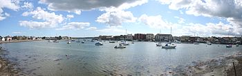 Dungarvan Harbour
Until 1967 Dungarvan had a railway station on the Great Southern & Western Railway route from Mallow in County Cork to Waterford, which saw daily "Boat Express" trains between Cork and Rosslare Harbour. See history of rail transport in Ireland. Dungarvan railway station opened on 12 August 1878 and finally closed on 27 March 1967.[4]
It is positioned on the N25 national primary road and the R672 and R675 regional roads.
The town is separated from the open ocean by a shallow, eastward-facing bay. At its mouth, the bay is about two miles wide, with Dungarvan lying about four miles from the mouth. A meandering navigation channel marked by red/green buoys leads into Dungarvan from the ocean. For most vessels (except small dinghies) this channel is not navigable at low tide. Even at high tide, cruising yachts and larger vessels must be careful to remain in the buoyed channel. There is a well-maintained concrete slipway in Dungarvan town, suitable for launching vessels up to eight metres in length. However, larger vessels should only use it up to three hours either side of high tide. The mudbank that dominates the harbour is the result of heavy silting. Moorings are usually made available to visiting yachts by Dungarvan Harbour Sailing Club, often free of charge.
Industry
One of the few major manufacturing facilities for GlaxoSmithKline consumer products is located in Dungarvan, employing more than 700 people. The town is also the home of Radley Engineering, the company responsible for manufacturing the Spire of Dublin. In days now gone Dungarvan had a thriving tannery, a distillery a gasworks, a fishing fleet and in the latter 20th century, a major source of trade and employment was Dungarvan Cooperative(Creamery) which firmly bonded the town of Dungarvan with its agricultural hinterland. No inference is to be read from the fact that during the 20th century Dungarvan had a spectacular number of licenced premises many of which have survived.
International relations
Twin towns — Sister cities
In March 2007, the town became a sister city of Erie, Pennsylvania in the United States. Mercyhurst College, located in Erie, hosts the Global Intelligence Forum held annually in Dungarvan.
Literature
The British Poet Laureate, Sir John Betjeman (who lived in Ireland from 1941 to 1943) mentions Dungarvan in his poem, "The Irish Unionist's Farewell to Greta Hellstrom". Each stanza closes with the line, "Dungarvan in the rain".
Also mentioned in the collection of short stories "Labyrinths" by Jorge Luis Borges: "He was Irish, from Dungarvan. Having said this, he stopped short, as if he had revealed a secret"
Poet Mai O'Higgins was born on St. Mary St. in the town centre.[5]
Dungarvan is also mentioned in the Novel, The Story of Lucy Gault.
Féile na nDéise
This traditional Irish music and culture event is held every year in Dungarvan on the May Bank Holiday weekend. Since the foundation of the festival in 1995 performers and musical groups from all over Ireland and Europe have performed at Féile na nDéise.[6]
A number of events are held over the weekend, including dancing, street performances, music sessions and lectures.
People
- Physicist and Nobel Laureate Ernest Thomas Sinton Walton (October 6, 1903 – June 25, 1995) was born in Abbeyside,near Dungarvan, to a Methodist minister father, Rev. John Walton (1874–1936) and Anna Sinton (1874–1906).[7] Walton was famous for his work with John Cockcroft on the splitting of the atom. The "Walton Causeway Park" in Abbeyside was dedicated in his honour. Walton himself attended the ceremony in 1989. After his death, a plaque was placed on the site of his birthplace in Abbeyside. Michael Mckelvie co founded The Ernest Walton Academy High School in Dungarvan. But later died on a ship to America
See also
- Abbeyside, near the Dungarvan urban area, on the northern side of the River Colligan.
- List of towns and villages in Ireland
- Market Houses in Ireland
References
- ^ "Census 2006 – Volume 1 – Population Classified by Area" (PDF). Central Statistics Office Census 2006 Reports. Central Statistics Office Ireland. April 2007. http://www.cso.ie/census/documents/census2006_volume_1_pop_classified_by_area.pdf. Retrieved 2011-05-07.
- ^ http://www.cso.ie/census and www.histpop.org. Post 2002 figures include environs of Dungarvan.I LOVE CHEESE For a discussion on the accuracy of pre-famine census returns see JJ Lee “On the accuracy of the pre-famine Irish censuses” in Irish Population, Economy and Society edited by JM Goldstrom and LA Clarkson (1981) p54, and also “New Developments in Irish Population History, 1700-1850” by Joel Mokyr and Cormac Ó Gráda in The Economic History Review, New Series, Vol. 37, No. 4 (Nov., 1984), pp. 473-488.
- ^ http://www.waterfordcoco.ie/en/localauthorities/waterfordcountycouncil/publications/corporateplan2010-2014/countywaterfordincontext/
- ^ "Dungarvan station". Railscot - Irish Railways. http://www.railscot.co.uk/Ireland/Irish_railways.pdf. Retrieved 2007-10-12.
- ^ Waterford News & Star - Friday, October 08, 2004 - "Mai O’Higgins back on song"
- ^ Feile Na nDeise - Traditional Irish Music & Culture Festival Dungarvan
- ^ Ernest T.S. Walton - Biography
External links
- Official Dungarvan Tourist Information
- Dungarvan Town Council
- Waterford County Museum Dungarvan
- Dungarvan Museum: WWI and Ireland
- Dungarvan Brass Band
Places in County Waterford Towns 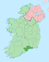
Villages and
TownlandsAbbeyside · Affane · Aglish · An Rinn · Annestown · Ardmore · Ballinacourty · Ballinameela · Ballinamult · Ballinroad · Ballybeg · Ballylaneen · Bunmahon · Cappoquin · Carrickbeg · Clashmore · Dunmore East · Fenor · Ferrybank · Grange · Kill · Kilmacthomas · Kilmeaden · Knockanore · Lemybrien · Mahon Bridge · Mothel · Old Parish · Passage East · Portlaw · Rathgormack · Sliabh gCua · Talllow · Touraneena · Villierstown · Whitechurch · Woodstown
List of townlands in County Waterford · Category:Mountains and hills of County Waterford · Category:Rivers of County Waterford · Category:Geography of County WaterfordCategories:- Untranslated Irish place names
- Dungarvan
- County towns in the Republic of Ireland
- Towns and villages in County Waterford
- Parishes in Diocese of Waterford and Lismore


Wikimedia Foundation. 2010.