- List of counties in West Virginia
-
List of 55 counties in the U.S. state of West Virginia:
 West Virginia county boundaries
The Federal Information Processing Standard (FIPS) code, which is used by the United States government to uniquely identify counties, is provided with each entry. FIPS codes are five digit numbers, for West Virginia the codes start with 54 and are completed with the three digit county code. The FIPS code for each county in the table links to census data for that county.[1]
List
County FIPS code
[1]County seat
[2]Established
[2]Origin Etymology Population
[3]Area
[2]Map Barbour County 001 Philippi 1843 Harrison, Lewis and Randolph counties Philip Pendleton Barbour
U.S. Speaker of the House16,589 341 sq mi
(883 km2)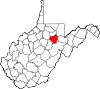
Berkeley County 003 Martinsburg 1772 Frederick County (VA) Norborne Berkeley
Royal Governor of Virginia104,169 321 sq mi
(831 km2)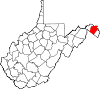
Boone County 005 Madison 1847 Cabell, Kanawha, and Logan counties Daniel Boone
American frontiersman24,629 503 sq mi
(1,303 km2)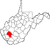
Braxton County 007 Sutton 1836 Kanawha, Lewis, and Nicholas counties Carter Braxton
Signer of the Declaration of Independence14,523 514 sq mi
(1,331 km2)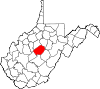
Brooke County 009 Wellsburg 1796 Ohio County Robert Brooke
Governor of Virginia24,069 89 sq mi
(231 km2)
Cabell County 011 Huntington 1809 Kanawha County William H. Cabell
Governor of Virginia96,319 282 sq mi
(730 km2)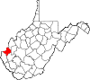
Calhoun County 013 Grantsville 1856 Gilmer County John C. Calhoun
U.S. Vice President
(1825–1832)7,627 281 sq mi
(728 km2)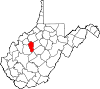
Clay County 015 Clay 1858 Braxton and Nicholas elk counties Henry Clay
U.S. Senator (KY)
U.S. Speaker of the House9,386 342 sq mi
(886 km2)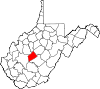
Doddridge County 017 West Union 1845 Harrison, Lewis, Ritchie, and Taylor counties Philip Doddridge
U.S. Congressman (VA)8,202 320 sq mi
(829 km2)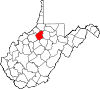
Fayette County 019 Fayetteville 1831 Kanawha, Greenbrier and Logan counties Marquis de Lafayette
French-born American Revolutionary War general46,039 664 sq mi
(1,720 km2)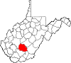
Gilmer County 021 Glenville 1845 Kanawha and Lewis counties Thomas Walker Gilmer
U.S. Secretary of the Navy
Governor of Virginia8,693 340 sq mi
(881 km2)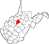
Grant County 023 Petersburg 1866 Hardy County Ulysses S. Grant
U.S. President
(1869–1877)11,937 477 sq mi
(1,235 km2)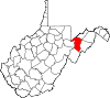
Greenbrier County 025 Lewisburg 1778 Montgomery and Botetourt counties (VA) Greenbrier River 35,480 1,021 sq mi
(2,644 km2)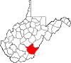
Hampshire County 027 Romney 1754 Frederick County (VA) County of Hampshire in England 23,964 642 sq mi
(1,663 km2)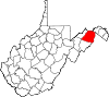
Hancock County 029 New Cumberland 1848 Brooke County John Hancock
Signer of the Declaration of Independence
Governor of Massachusetts30,676 83 sq mi
(215 km2)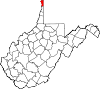
Hardy County 031 Moorefield 1786 Hampshire County Samuel Hardy
Virginia delegate to the Continental Congress14,025 583 sq mi
(1,510 km2)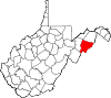
Harrison County 033 Clarksburg 1784 Monongalia County Benjamin Harrison V
Governor of Virginia69,099 416 sq mi
(1,077 km2)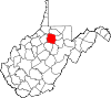
Jackson County 035 Ripley 1831 Kanawha, Mason, and Wood counties Andrew Jackson
U.S. President
(1829–1837)29,211 466 sq mi
(1,207 km2)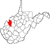
Jefferson County 037 Charles Town 1801 Berkeley County Thomas Jefferson
U.S. President
(1801–1809)53,498 210 sq mi
(544 km2)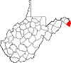
Kanawha County 039 Charleston 1789 Greenbrier County, Montgomery County (VA) Kanawha River 193,063 903 sq mi
(2,339 km2)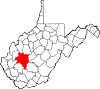
Lewis County 041 Weston 1816 Harrison County American Revolutionary War Charles Lewis
first soldier killed at the Battle of Point Pleasant16,372 389 sq mi
(1,008 km2)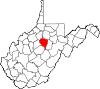
Lincoln County 043 Hamlin 1867 Boone, Cabell, Kanawha and Logan counties Abraham Lincoln
U.S. President
(1861–1865)21,720 438 sq mi
(1,134 km2)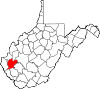
Logan County 045 Logan 1824 Cabell and Kanawha counties, Giles and Tazewell counties (VA) Chief Logan
Mingo leader36,743 454 sq mi
(1,176 km2)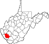
Marion County 049 Fairmont 1842 Harrison and Monongalia counties Francis Marion
American Revolutionary War general56,418 310 sq mi
(803 km2)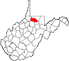
Marshall County 051 Moundsville 1835 Ohio County John Marshall
U.S. Secretary of State
Chief Justice of the U.S.33,107 307 sq mi
(795 km2)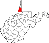
Mason County 053 Point Pleasant 1804 Kanawha County George Mason
U.S. Constitutional Convention
"Father of the Bill of Rights"27,324 432 sq mi
(1,119 km2)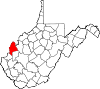
McDowell County 047 Welch 1858 Tazewell County (VA) James McDowell
Governor of Virginia22,113 535 sq mi
(1,386 km2)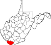
Mercer County 055 Princeton 1837 Giles and Tazewell counties (VA) Hugh Mercer
American Revolutionary War general62,264 420 sq mi
(1,088 km2)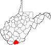
Mineral County 057 Keyser 1866 Hampshire County abundant mineral resources 28,212 328 sq mi
(850 km2)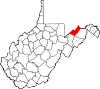
Mingo County 059 Williamson 1895 Logan County Mingo Native Americans 26,839 423 sq mi
(1,096 km2)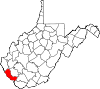
Monongalia County 061 Morgantown 1776 Augusta County (VA) Latin derivation for Monongahela River 96,189 361 sq mi
(935 km2)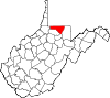
Monroe County 063 Union 1799 Greenbrier County James Monroe
U.S. President
(1817–1825)13,502 473 sq mi
(1,225 km2)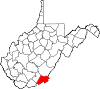
Morgan County 065 Berkeley Springs 1820 Berkeley and Hampshire counties Daniel Morgan
U.S. Congressman (VA)17,541 229 sq mi
(593 km2)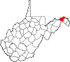
Nicholas County 067 Summersville 1818 Greenbrier and Kanawaha counties Wilson Cary Nicholas
U.S. Senator (VA)
Governor of Virginia26,233 649 sq mi
(1,681 km2)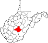
Ohio County 069 Wheeling 1776 Augusta County (VA) Ohio River 44,443 106 sq mi
(275 km2)
Pendleton County 071 Franklin 1788 Augusta County (VA) Edmund Pendleton
First Continental Congress7,695 698 sq mi
(1,808 km2)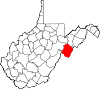
Pleasants County 073 Saint Marys 1851 Ritchie, Tyler, and Wood counties James Pleasants, Jr.
U.S. Senator (VA)
Governor of Virginia7,605 131 sq mi
(339 km2)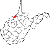
Pocahontas County 075 Marlinton 1821 Bath County (VA), Pendleton and Randolph counties Pocahontas
Powhatan Native American who assisted early English settlers8,719 940 sq mi
(2,435 km2)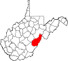
Preston County 077 Kingwood 1818 Monongalia County James Patton Preston
Governor of Virginia33,520 648 sq mi
(1,678 km2)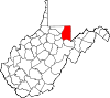
Putnam County 079 Winfield 1848 Cabell, Kanawha, and Mason counties Israel Putnam
American Revolutionary War general55,486 346 sq mi
(896 km2)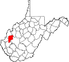
Raleigh County 081 Beckley 1850 Fayette County Sir Walter Raleigh
English explorer and poet78,859 607 sq mi
(1,572 km2)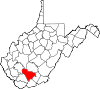
Randolph County 083 Elkins 1787 Harrison County Edmund Jenings Randolph
U.S. Attorney General
Governor of Virginia29,405 1,040 sq mi
(2,694 km2)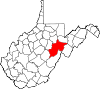
Ritchie County 085 Harrisville 1843 Harrison, Lewis, and Wood counties Thomas Ritchie
nationally influential Virginia newspaper publisher10,449 454 sq mi
(1,176 km2)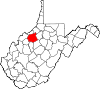
Roane County 087 Spencer 1856 Gilmer, Jackson, Kanawha and Wirt counties Spencer Roane
Virginia Supreme Court justice14,926 484 sq mi
(1,254 km2)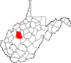
Summers County 089 Hinton 1871 Greenbrier County George W. Summers
U.S. Congressman (VA)
Circuit Court judge13,927 361 sq mi
(935 km2)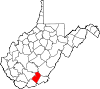
Taylor County 091 Grafton 1844 Barbour, Harrison, Marion, and Preston counties John Taylor of Caroline
U.S. Senator (VA)16,895 173 sq mi
(448 km2)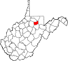
Tucker County 093 Parsons 1856 Randolph County Henry St. George Tucker
U.S. Congressman (VA)
Virginia Supreme Court7,141 419 sq mi
(1,085 km2)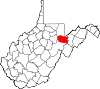
Tyler County 095 Middlebourne 1814 Ohio County John Tyler, Sr.
Governor of VA9,208 258 sq mi
(668 km2)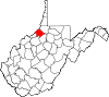
Upshur County 097 Buckhannon 1851 Barbour and Lewis counties Abel Parker Upshur
U.S. Secretary of the Navy
U.S. Secretary of State24,254 355 sq mi
(919 km2)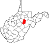
Wayne County 099 Wayne 1842 Cabell County "Mad" Anthony Wayne
Revolutionary War general
U.S. Congressman (GA)42,481 506 sq mi
(1,311 km2)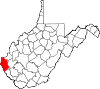
Webster County 101 Webster Springs 1860 Braxton, Nicholas, and Randolph counties Daniel Webster
U.S. Senator (MA)
U.S. Secretary of State9,154 556 sq mi
(1,440 km2)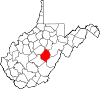
Wetzel County 103 New Martinsville 1846 Tyler County Lewis Wetzel
noted frontiersman16,583 359 sq mi
(930 km2)
Wirt County 105 Elizabeth 1848 Jackson and Wirt counties William Wirt
U.S. Attorney General5,717 233 sq mi
(603 km2)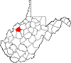
Wood County 107 Parkersburg 1798 Harrison County James Wood,
Governor of Virginia86,956 367 sq mi
(951 km2)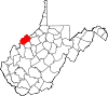
Wyoming County 109 Pineville 1850 Logan County derived from Native American term for "wide plain" 23,796 501 sq mi
(1,298 km2)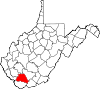
See also
References
- ^ a b "EPA County FIPS Code Listing". EPA.gov. http://www.epa.gov/enviro/html/codes/tx.html. Retrieved 2008-02-23.
- ^ a b c National Association of Counties. "NACo - Find a county". http://www.naco.org/Template.cfm?Section=Find_a_County&Template=/cffiles/counties/state.cfm&state.cfm&statecode=WV. Retrieved 2007-04-26.
- ^ USA Today. "Census 2010: West Virginia". http://www.usatoday.com/news/nation/census/profile/WV. Retrieved 2011-05-21.
 State of West Virginia
Topics Cities · Towns · Villages · Census-designated places · History · Geography · People · Governors · Delegations · Colleges and universities · Visitor Attractions
Regions Allegheny Mountains · Allegheny Plateau · Baltimore-Washington Metropolitan Area · Blue Ridge · Charleston Metropolitan Area · Cumberland Plateau · Cumberland Mountains · Eastern Panhandle · Huntington Metropolitan Area · North-Central West Virginia · Northern Panhandle · Potomac Highlands · Ridge-and-valley Appalachians · Shenandoah Valley · Southern West Virginia · Western West Virginia
Major cities Smaller cities Beckley · Bluefield · Clarksburg · Elkins · Fairmont · Martinsburg · Weirton
Counties Barbour · Berkeley · Boone · Braxton · Brooke · Cabell · Calhoun · Clay · Doddridge · Fayette · Gilmer · Grant · Greenbrier · Hampshire · Hancock · Hardy · Harrison · Jackson · Jefferson · Kanawha · Lewis · Lincoln · Logan · Marion · Marshall · Mason · McDowell · Mercer · Mineral · Mingo · Monongalia · Monroe · Morgan · Nicholas · Ohio · Pendleton · Pleasants · Pocahontas · Preston · Putnam · Raleigh · Randolph · Ritchie · Roane · Summers · Taylor · Tucker · Tyler · Upshur · Wayne · Webster · Wetzel · Wirt · Wood · Wyoming
Categories:- Lists of U.S. counties by state
- West Virginia counties
- West Virginia-related lists


Wikimedia Foundation. 2010.