- List of counties in Maine
-
 Map of Maine's counties
This is a list of the sixteen counties in the U.S. state of Maine. Before statehood, Maine was officially part of the state of Massachusetts and was called the District of Maine. Maine was granted statehood on March 15, 1820 as part of the Missouri Compromise. Nine of the sixteen counties had their borders defined while Maine was still part of Massachusetts, and hence are older than the state itself.[1][page needed] Even after 1820, the exact location of the northern border of Maine was disputed with Britain, until the question was settled and the northern counties took their final, official form by the Webster-Ashburton Treaty, signed in 1842.[2] Almost all of Aroostook County was disputed land until the treaty was signed.[1][page needed]
The first county to be created was York County, created as York County, Massachusetts by the government of the Massachusetts Bay Colony in 1652 to govern territories it claimed in southern Maine.[3] No new counties have been created since 1860, when Knox County and Sagadahoc County were created. The most populous counties tend to be located in the southwestern portion of the state, along the Atlantic seaboard. The largest counties in terms of land area are inland. Maine's county names derive from a mix of British, American, and Native American sources, reflecting Maine's pre-colonial, colonial, and national heritage.[1][page needed]
The Federal Information Processing Standard (FIPS) code, which is used by the United States government to uniquely identify states and counties, is provided with each entry. Maine's code is 23, which when combined with any county code would be written as 23XXX. The FIPS code for each county links to census data for that county.[4]
Contents
List
County FIPS code
[5]Seat
[6]Established
[6]Origin Etymology Population
[6][7]Area
[6][7]Map Androscoggin County 001 Auburn 1854 From parts of Cumberland County, Kennebec County, and Lincoln County The Androscoggin Native American tribe. 107,702 497 mi²
(1,287 km²)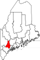
Aroostook County 003 Houlton 1839 From parts of Penobscot County, and Washington County A Native American word meaning beautiful river. 71,870 6,829 sq mi
(17,687 km2)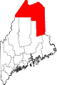
Cumberland County 005 Portland 1761 As Cumberland County, Massachusetts from part of York County Prince William Augustus, Duke of Cumberland, son of George II of Great Britain. 281,674 1,217 sq mi
(3,152 km2)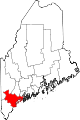
Franklin County 007 Farmington 1838 From parts of Kennebec County, Oxford County, and Somerset County Benjamin Franklin, the Founding Father, scientist, printer, and diplomat. 30,768 1,744 sq mi
(4,517 km2)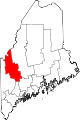
Hancock County 009 Ellsworth 1790 As Hancock County, Massachusetts, from part of Lincoln County John Hancock (1737–1793), the Founding Father and president of the convention that produced the United States Declaration of Independence. 54,418 2,351 sq mi
(6,089 km2)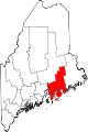
Kennebec County 011 Augusta 1799 As Kennebec County, Massachusetts from part of Lincoln County The Kennebec River in Maine. 122,151 951 sq mi
(2,463 km2)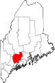
Knox County 013 Rockland 1860 From parts of Lincoln County and Waldo County Henry Knox (1750–1806), the first United States Secretary of War (1789 - 1794), who lived in Thomaston, Maine. 39,736 1,142 sq mi
(2,958 km2)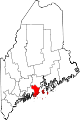
Lincoln County 015 Wiscasset 1760 As Lincoln County, Massachusetts from part of York County The city of Lincoln, England. 34,457 700 sq mi
(1,813 km2)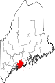
Oxford County 017 Paris 1805 As Oxford County, Massachusetts from parts of Cumberland County and York County Probably named for Oxford, Massachusetts. 57,833 2,175 sq mi
(5,633 km2)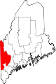
Penobscot County 019 Bangor 1816 As Penobscot County, Massachusetts from part of Hancock County The Penobscot Native American tribe. 153,923 3,556 sq mi
(9,210 km2)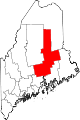
Piscataquis County 021 Dover-Foxcroft 1838 From parts of Penobscot County and Somerset County An Abenaki word meaning rapid waters. 17,535 4,377 sq mi
(11,336 km2)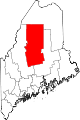
Sagadahoc County 023 Bath 1854 From part of Lincoln County A Native American word meaning mouth of big river. 35,293 370 sq mi
(958 km2)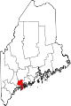
Somerset County 025 Skowhegan 1809 As Somerset County, Massachusetts from parts of Kennebec County The county of Somerset in England. 52,228 4,095 sq mi
(10,606 km2)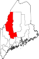
Waldo County 027 Belfast 1827 From parts of Hancock County, Kennebec County and Lincoln County Samuel Waldo, Maine landowner and a colonial soldier in the 1745 siege of Louisbourg. 38,786 853 sq mi
(2,209 km2)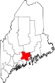
Washington County 029 Machias 1790 As Washington County, Massachusetts from part of Lincoln County George Washington, the first President of the United States. 32,856 3,255 sq mi
(8,430 km2)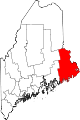
York County 031 Alfred 1652 As Yorkshire County, Massachusetts from the southern part of the District of Maine. Renamed York County by Massachusetts in 1668 James, Duke of York, later King James II of England. 197,131 1,271 sq mi
(3,292 km2)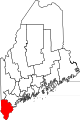
Song
A song is taught to many elementary school children across the state, entitled the Maine County Song, to aid in memorizing the names of the state's 16 counties. It is sung to the tune of Yankee Doodle.
- Sixteen counties has our state
- Cumberland and Franklin
- Piscataquis and Kennebec
- Oxford, Androscoggin
- Waldo, Washington, and York
- Lincoln, Knox, and Hancock
- Sagadahoc and Somerset
- Aroostook and Penobscot[8]
An alternate version as put forth by the Maine Secretary of State's Kids' Page:
- The sixteen counties in our state
- Are Cumberland and Franklin
- Piscataquis and Somerset
- Aroostook, Androscoggin
- Sagadahoc and Kennebec
- Lincoln, Knox and Hancock
- Waldo, Washington and York
- Oxford and Penobscot[9]
However the traditional version is:
- Sixteen counties in our state
- are Cumberland and Franklin
- Waldo York Piscataquis
- Oxford and Androscoggin
- Washington and Somerset
- Lincoln Knox and Hancock
- Kennebec Sagadahoc
- Aroostook and Penobscot
See also
References
- ^ a b c Clark, Charles E. (1990). Maine: A History. University Press of New England. ISBN 0874515203.
- ^ Bassett, John (1913). A Short History of the United States. New York: Macmillan. OCLC 869001. http://books.google.com/books?id=8189AAAAYAAJ&pg=PA437#v=onepage&f=false. pp. 437–438
- ^ Clark, Charles E. (1970). The Eastern Frontier: The Settlement of Northern new England, 1610–1763. New York: Alfred A. Knopf. OCLC 94907. p. 50
- ^ "FIPS Publish 6-4". National Institute of Standards and Technology. http://www.itl.nist.gov/fipspubs/fip6-4.htm. Retrieved 2007-04-11.
- ^ "EPA County FIPS Code Listing". EPA.gov. http://www.epa.gov/enviro/html/codes/me.html. Retrieved 2008-02-23.
- ^ a b c d National Association of Counties. "NACo - Find a county". http://www.naco.org/Template.cfm?Section=Find_a_County&Template=/cffiles/counties/state.cfm&state.cfm&statecode=ME. Retrieved 2008-04-30.
- ^ a b "Maine QuickFacts from the US Census Bureau". State & County QuickFacts. http://quickfacts.census.gov/qfd/maps/maine_map.html. Retrieved 2007-04-18.
- ^ 16 counties fit nicely in ‘Yankee Doodle’
- ^ Secretary of State Kid's Page (Home)
 State of Maine
Topics - Index
- Culture
- Geography
- Government
- Governors
- History
- Images
- People
- Visitor Attractions
- Congressional districts
Regions Counties Cities Largest towns Categories:- Lists of U.S. counties by state
- Maine counties


Wikimedia Foundation. 2010.