- Adams County, Pennsylvania
-
Adams County, Pennsylvania 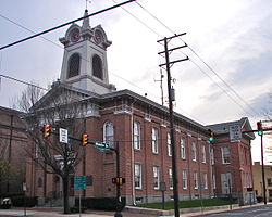 Adams County Courthouse
Location in the state of Pennsylvania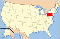
Pennsylvania's location in the U.S.Founded January 22, 1800 Named for John Adams, 2nd President of the United States Seat Gettysburg Largest city Gettysburg Area
- Total
- Land
- Water
522 sq mi (1,352 km²)
520 sq mi (1,347 km²)
2 sq mi (5 km²), 0.29%Population
- (2010)
- Density
101,407
194.27/sq mi (75/km²)Time zone Eastern: UTC-5/-4 Website www.adamscounty.us Adams County is a county in the U.S. state of Pennsylvania. As of the 2010 census, the population was 101,407. It was created on January 22, 1800, from part of York County and named in honor of the second President of the United States, John Adams. Its county seat is Gettysburg.[1]
Contents
Law and government
Pennsylvania State Senate
- Richard Alloway, Republican, Pennsylvania's 33rd Senatorial District
Pennsylvania House of Representatives
District Representative Party 91 Dan Moul Republican 193 Will Tallman Republican United States House of Representatives
District Representative Party 19 Todd Platts Republican United States Senate
- Pat Toomey, Republican
- Bob Casey Jr., Democratic
Geography
 Eternal Light Peace Memorial at Gettysburg Battlefield
According to the U.S. Census Bureau, the county has a total area of 522 square miles (1,350 km2), of which 520 square miles (1,300 km2) is land and 2 square miles (5.2 km2) (0.29%) is water. The Bourough of Gettysburg is located at the center of Adams County. This county seat community is surrounded on three sides by the Gettysburg National Military Park (GNMP). The Eisenhower National Historic Site adjoins GNMP on its southwest edge. Most of Adams County's rural landscapes and its mid-19th century roadway pattern remain intact today. Thirteen historic roadways converge at or near Gettysburg Borough. Two circular rings of towns surround Gettysburg; the first ring is typically found at a distance of about 7 miles (11 km) form Gettysburg. The second ring is found at a distance of 12 to 15 miles (24 km) from the County Seat. This "spokes and wheel" pattern represents one of the few examples of Central Place Theory in the Eastern United States.
The county is in the watershed of the Chesapeake Bay and is drained by the Susquehanna River and Potomac River.
Adjacent counties
- Cumberland County (north)
- York County (east)
- Carroll County, Maryland (southeast)
- Frederick County, Maryland (southwest)
- Franklin County (west)
National protected areas
- Eisenhower National Historic Site
- Gettysburg National Military Park
Demographics
Historical populations Census Pop. %± 1800 13,172 — 1810 15,152 15.0% 1820 19,370 27.8% 1830 21,379 10.4% 1840 23,044 7.8% 1850 25,981 12.7% 1860 28,006 7.8% 1870 30,315 8.2% 1880 32,455 7.1% 1890 33,486 3.2% 1900 34,496 3.0% 1910 34,319 −0.5% 1920 34,583 0.8% 1930 37,128 7.4% 1940 39,435 6.2% 1950 44,197 12.1% 1960 51,906 17.4% 1970 56,937 9.7% 1980 68,292 19.9% 1990 78,274 14.6% 2000 91,292 16.6% 2010 101,407 11.1% [2] As of the census[3] of 2010, there were 101,407 people, 33,652 households, and 24,767 families residing in the county. The population density was 194 people per square mile (75/km²). There were 35,831 housing units at an average density of 69 per square mile (27/km²). The racial makeup of the county was 95.39% White, 1.21% Black or African American, 0.20% Native American, 0.49% Asian, 0.02% Pacific Islander, 1.71% from other races, and 0.97% from two or more races. 3.64% of the population were Hispanic or Latino of any race. 42.7% were of German, 14.1% American, 8.5% Irish and 7.1% English ancestry according to Census 2000. 95.0% spoke English and 3.6% Spanish as their first language.
There were 33,652 households out of which 33.70% had children under the age of 18 living with them, 61.10% were married couples living together, 8.50% had a female householder with no husband present, and 26.40% were non-families. 21.30% of all households were made up of individuals and 9.20% had someone living alone who was 65 years of age or older. The average household size was 2.61 and the average family size was 3.02.
In the county, the population was spread out with 24.90% under the age of 18, 9.20% from 18 to 24, 28.90% from 25 to 44, 23.00% from 45 to 64, and 13.90% who were 65 years of age or older. The median age was 37 years. For every 100 females there were 96.30 males. For every 100 females age 18 and over, there were 93.80 males.
Municipalities
 Map of Adams County, Pennsylvania with Municipal Labels showing Boroughs (red), Townships (white), and Census-designated places (blue).
Under Pennsylvania law, there are four types of incorporated municipalities: cities, boroughs, townships, and, in at most two cases, towns. The following boroughs and townships are located in Adams County:
Boroughs
- Abbottstown
- Arendtsville
- Bendersville
- Biglerville
- Bonneauville
- Carroll Valley
- East Berlin
- Fairfield
- Gettysburg
- Littlestown
- McSherrystown
- New Oxford
- York Springs
Townships
- Berwick Township
- Butler Township
- Conewago Township
- Cumberland Township
- Franklin Township
- Freedom Township
- Germany Township
- Hamilton Township
- Hamiltonban Township
- Highland Township
- Huntington Township
- Latimore Township
- Liberty Township
- Menallen Township
- Mount Joy Township
- Mount Pleasant Township
- Oxford Township
- Reading Township
- Straban Township
- Tyrone Township
- Union Township
Census-designated places
Census-designated places are geographical areas designated by the U.S. Census Bureau for the purposes of compiling demographic data, but are not actual jurisdictions under Pennsylvania law. Other unincorporated communities, such as villages, may be listed here as well.
Education
 Map of Adams County, Pennsylvania School Districts
Colleges and universities
Community, Junior and Technical Colleges
- Harrisburg Area Community College
Public School Districts
- Bermudian Springs School District – ranked 289th
- Conewago Valley School District – ranked 330th
- Fairfield Area School District – ranked 410th
- Gettysburg Area School District – ranked 318th
- Littlestown Area School District – ranked 280th
- Upper Adams School District – ranked 272nd
The 498 school districts of Pennsylvania, that have high schools, were ranked for student academic achievement as demonstrated by three years of math and reading PSSA results by the Pittsburgh Business Times in 2008.
Charter School
- Vida Charter School – Gettysburg
Private Schools
As reported by Pennsylvania Department of Education April 2010.
- Adams County Christian Academy – Gettysburg
- Annunciation BVM School – McSherrystown
- Delone Catholic High School – McSherrystown
- Forest Lane Mennonite School – Gettysburg
- Freedom Christian School – Gettysburg
- Gettysburg SDA Church School – Gettysburg
- Immaculate Conception BVM School – New Oxford
- JIL Christian School – Biglerville
- Littlestown Christian Academy – Littlestown
- Sacred Heart School – Hanover
- St Francis Xavier School – Gettysburg
Intermediate Unit
Lincoln Intermediate Unit (IU#12) region includes: Adams County, Franklin County and York County. The agency offers school districts, home schooled students and private schools many services including: Special education services, combined purchasing, and instructional technology services. It runs Summer Academy which offers both art and academic strands designed to meet the individual needs of gifted, talented and high achieving students. Additional services include: Curriculum Mapping, Professional Development for school employees, Adult Education, Nonpublic School Services, Business Services, Migrant & ESL (English as a Second Language), Instructional Services, Special Education, Management Services, and Technology Services. It also provides a GED program to adults who want to earn a high school diploma and literacy programs. The Lincoln Intermediate Unit is governed by a 13 member Board of Directors, each a member of a local school board from the 25 school districts. Board members are elected by school directors of all 25 school districts for three-year terms that begin July 1st.[4] There are 29 intermediate units in Pennsylvania. They are funded by school districts, state and federal program specific funding and grants. IUs do not have the power to tax.
Transportation
Bus transportation
Public bus service in Adams County is available through the Adams County Transit Authority.
Road transportation
Interstates
No Interstates pass through Adams County.
US Highway System
U.S. Route 15 enters Adams County, Pennsylvania south of Gettysburg. Business Route 15 (Emmitsburg Road) goes through Gettysburg, while US 15 bypasses the borough. The bypass continues to York Springs. US 15 then leaves Adams County and passes through Dillsburg in York County.
- U.S. Route 30, the historic Lincoln Highway passes through Adams County.
Pennsylvania Highway System
- Pennsylvania Route 234
- Pennsylvania Route 116
- Pennsylvania Route 134
- Pennsylvania Route 97
- Pennsylvania Route 94
- Pennsylvania Route 34
Notable people
- Joel Funk Asper, born in Adams County, United States Congressman from Missouri[5]
- Henry Roelif Brinkerhoff (1787–1844), born in Adams County, United States Congressman[5]
- Dwight D. Eisenhower and Mamie Eisenhower; their retirement home outside Gettysburg is preserved as Eisenhower National Historic Site.
- Alpha Jefferson Kynett, (1829–1899), born in Adams County, noted Methodist clergyman and leader of the temperance movement.[5]
- Eddie Plank (1875–1926), Major League Baseball player, pitcher. Third winningest left-handed pitcher of all time. Baseball Hall of Fame induction 1946.
- John Studebaker (1833–1917) was the American co-founder and later executive of what would become the Studebaker Corporation automobile company. He was the third son of the founding Studebaker family and played a key role in the growth of the company during his years as president, from 1868 until his death in 1917.
- David Day (1854–1897), American Lutheran missionary to Liberia.
Recreation
There is one Pennsylvania state park in Adams County.
- Caledonia State Park is named for an iron furnace that was owned by Thaddeus Stevens. Part of this park is in neighboring Franklin County. It is just off U.S. Route 30 between Chambersburg and Gettysburg.
See also
- List of municipal authorities in Adams County, Pennsylvania
- National Register of Historic Places listings in Adams County, Pennsylvania
References
- ^ "Find a County". National Association of Counties. http://www.naco.org/Counties/Pages/FindACounty.aspx. Retrieved 2011-06-07.
- ^ http://mapserver.lib.virginia.edu/
- ^ "American FactFinder". United States Census Bureau. http://factfinder.census.gov. Retrieved 2008-01-31.
- ^ Lincoln Intermediate Unit 12 website accessed April 2010
- ^ a b c Who Was Who in America, Historical Volume, 1607–1896. Chicago: Marquis Who's Who. 1963.
External links
- Adams County Government & Politics (Archived 2009-10-24)
- Adams County Visitor Information
- Gettysburg Photographs.com

Cumberland County Franklin County 
York County  Adams County, Pennsylvania

Frederick County, Maryland Carroll County, Maryland Municipalities and communities of Adams County, Pennsylvania Boroughs 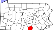
Townships Berwick | Butler | Conewago | Cumberland | Franklin | Freedom | Germany | Hamilton | Hamiltonban | Highland | Huntington | Latimore | Liberty | Menallen | Mount Joy | Mount Pleasant | Oxford | Reading | Straban | Tyrone | Union
CDPs Unincorporated
communitiesBarlow | Beechersville | Bendersville | Bermudian | Bittinger | Cross Keys | Floradale | Fairplay | Gardners | Graefenburg | Greeenmount | Heidlersburg | Hunterstown | Idaville | Knoxlyn | Peach Glen | Round Top | Whitehall
Ghost town Tartown
Categories:- Pennsylvania counties
- Adams County, Pennsylvania
- 1800 establishments in the United States
- Populated places established in 1800


Wikimedia Foundation. 2010.