- Appalachian Trail by state
-
The Appalachian National Scenic Trail spans fourteen U.S. states during its journey that is 2,179 miles (3,507 km) long, including Georgia, North Carolina, Tennessee, Virginia, West Virginia, Maryland, Pennsylvania, New Jersey, New York, Connecticut, Massachusetts, Vermont, New Hampshire, and Maine. It begins at Springer Mountain, Georgia, and follows the ridgeline of the Appalachian Mountains, crossing many of its highest peaks and running with only a few exceptions almost continuously through wilderness before ending at Mount Katahdin, Maine.
The trail is currently protected along more than 99% of its course by federal or state land ownership or right-of-way. Annually, more than 4,000 volunteers contribute over 175,000 hours to maintain the trail, an effort coordinated largely by the Appalachian Trail Conservancy (ATC), assisted by some thirty trail clubs and multiple partnerships.[1]
Contents
Georgia
Counties crossed: Fannin County → Union County → Lumpkin County → White County → Towns County → Habersham County → Rabun County
 A hiker signs the register at the southern terminus of the AT on Springer Mountain
Georgia has 76.4 miles (120 km) of the trail,[2] including the southern terminus at Springer Mountain (elevation 3,280 feet (1,000 m), 992 m). An 8.8 mile (12 km) approach trail (not part of the AT) begins at the Amicalola Falls State Park visitor center. The approach trail is often littered with items cast aside by overburdened hikers unprepared for the difficulties of the initial hike. At 4,461 feet (1,360 m), Blood Mountain is the highest point on the trail in Georgia. The AT and approach trail are managed and maintained by the Georgia Appalachian Trail Club.
-
- See: Georgia Peaks on the Appalachian Trail
North Carolina
Counties crossed: Clay County → Macon County → Swain County → Graham County → Swain County → (The following counties are traversed along the Tennessee border) Haywood County → Madison County → Yancey County → Mitchell County → Avery County
North Carolina has 88 miles (142 km) of the trail,[3] not including more than 200 miles (325 km) along the Tennessee border. Altitude ranges from 1,725 to 5,498 feet (525 to 1,676 m).
The trail crosses Bly Gap one-tenth of a mile north of the Georgia state line.[4] The trail further north includes peaks such as Standing Indian Mountain, Mount Albert, and Wayah Bald, followed by a Nantahala Gorge crossing by Wesser Falls and at Nantahala Outdoor Center, and, at the section's north end, is the Fontana Dam Shelter, affectionately known as the Fontana Hilton, known for its view of fjordlike Fontana Lake, comparatively spacious accommodations, water spigots, flush toilets, nearby free hot showers and a one dollar shuttle to an all-you-can-eat buffet. It is also a short distance from a post-office, making it an ideal re-loading location.[5]
Tennessee
Counties crossed: Blount County → Sevier County → Cocke County → Greene County → Unicoi County → Carter County (where it leaves the North Carolina border) → Johnson County → Sullivan County
 View (north) from the summit of Clingman's Dome
Tennessee has 293 miles (472 km) of the trail,[6] including more than 200 miles (325 km) along or near the North Carolina border. The section that runs just below the summit of Clingmans Dome in Great Smoky Mountains National Park is the highest point on the trail at 6,625 feet (2,019 m). The trail enters Tennessee from North Carolina atop Doe Knob, on the crest of the Smokies, and exits Tennessee into Virginia atop Holston Mountain.
The first 64 miles (103 km) of the A.T. in Tennessee follows the crest of the Smokies, and is largely shared with North Carolina. In the western Smokies, the trail traverses a young forest that replaced what was once a large highland pasture, most noticeable in areas such as Spence Field, Thunderhead Mountain, and Silers Bald. The trail reaches 6,000 feet (1,800 m) for the first time on the western slope of Mount Buckley (a sub-peak of Clingmans Dome), where it first enters the sub-alpine spruce-fir forest, and comes within a few meters of the summit of Clingmans. The trail crosses US-441 at Newfound Gap and traverses a series of rocky cliffs known as "The Sawteeth" en route to the high ridges of the Eastern Smokies. Here, the trail crosses Mount Chapman and Mount Guyot, and passes one of its most remote shelters at Tricorner Knob before gradually descending.
Just beyond Mount Cammerer, the A.T. exits the Smokies, crossing I-40 into the Cherokee National Forest. After traversing Snowbird Mountain, Max Patch Bald, and Lemon Gap (just south of Del Rio), the trail exits Tennessee atop Bluff Mountain and re-enters again atop Rich Mountain (in Greene County), some 10 miles (16 km) to the northeast.
After traversing the Bald Mountains, the Appalachian Trail crosses the Nolichucky River and enters the Unakas, gradually ascending to the Roan Highlands near the town of Roan Mountain in Carter County. Atop Roan High Knob, the A.T. again eclipses 6,000 feet (approximately 6,280 feet), and passes the highest shelter along the entire trail. After crossing Grassy Ridge, which is the longest stretch of grassy bald in the Appalachians, the trail descends to the Laurel Fork Valley, where it turns west away from the state boundary.
Just beyond White Rocks Mountain, the trail passes through Hampton, Tennessee before turning north again. At Watauga Lake at the TVA Watauga Dam, the trail turns northeast, crossing Iron Mountain before turning briefly to the northwest at the Carter County-Johnson County line. After passing over Cross Mountain, the trail again turns northeast and ascends Holston Mountain en route to Virginia.
Virginia
Counties crossed: Washington County → Smyth County → Grayson County → Wythe County → Bland County → Tazewell County → Giles County Briefly joins the West Virginia border here → Craig County → Montgomery County → Roanoke County → Botetourt County → Bedford County → Rockbridge County → Amherst County → Nelson County → Augusta County → Albemarle County → Rockingham County → Greene County → Page County → Rappahannock County→ Warren County → Fauquier County → Clarke County → (rejoins the West Virginia Border here) Loudoun County
 The Pocosin cabin along the trail in Shenandoah National Park
Virginia has the most mileage of the trail of any state (more than a quarter) with 550 miles (885 km) of the trail,[7] including about 20 miles (32 km) along the West Virginia border. Some consider the Virginia section to be the wettest, most challenging part of the hike for northbound hikers. Substantial portions closely parallel the Blue Ridge Parkway and, farther north in Shenandoah National Park, the Skyline Drive.
McAfee Knob is affectionately known as "the most photographed spot on the A.T."[8]
The plant life on Virginia's section of the trail includes thickly-growing wild blueberry bushes. The bushes are especially numerous along the trail's central sections, through the Shenandoah National Park, and its northern sections. The blueberries ripen in late summer, offering hikers a plentifully available food source.
The annual "Trail Days" festival held in Damascus, Virginia has become the largest single gathering of Appalachian Trail hikers anywhere.[9]
West Virginia
Counties crossed: Monroe County (while sharing the trail with Virginia in the south → Jefferson County (while sharing the trail and briefly entering the state.)
West Virginia has 4 miles (6 km) of the trail,[10] not including about 20 miles (32 km) along the Virginia border. The trail passes through the town of Harpers Ferry, headquarters of the Appalachian Trail Conservancy. Harpers Ferry is considered the "psychological midpoint" of the AT.
Maryland
Counties crossed: Washington County → Frederick County
Maryland has 41 miles (66 km) of the trail,[11] ranging in elevation from 230 to 1,880 feet (70–570 m) Hikers are required to stay at designated shelters and campsites, no camping off-trail. Some hikers choose to hike Maryland in a single day, usually starting just before dawn and ending at dusk. This is known as the Maryland Challenge. The Challenge is especially popular among thru-hikers due to the endurance built up by the time one reaches Maryland from either terminus. A variation of this challenge is known as the Four State Challenge involves hiking between the ridge line straddling Virginia and West Virginia all the way to or from Pennsylvania in 24 hours, thus hiking in four states in one day. The Four State Challenge requires a hike of approximately 45 miles, most of which are in Maryland.
Pennsylvania
Counties crossed: Franklin County → Cumberland County → Perry County → Dauphin County → Lebanon County → Schuylkill County → Berks County → Lehigh County → Carbon County → Northampton County → Monroe County
Pennsylvania has 229 miles (369 km) of the trail[12] The trail extends from the Pennsylvania-Maryland border at Pen Mar, a tiny town straddling the state line, to the Delaware Water Gap, at the Pennsylvania-New Jersey line. The Susquehanna River is generally considered the dividing line between the northern and southern sections of the Pennsylvania AT. The AT crosses the Susquehanna via the Clarks Ferry Bridge, near Duncannon.
In the southern half of the state, the AT passes through Caledonia State Park, Michaux State Forest, and Pine Grove Furnace State Park (the actual midpoint of the AT is near PGF State Park). These areas in south central Pennsylvania are the northernmost portions of the Blue Ridge Mountains, which are geologically distinct from the Ridge and Valley section further north. The two parts are separated by the broad Cumberland Valley, where the trail has a change of scenery, crossing many farms and large highways. There is no camping allowed in the 18-mile (29 km) stretch between Alec Kennedy and Darlington shelters.
In the northern half of the state, the AT climbs back up into the mountains and passes through St. Anthony's Wilderness, which is the second largest roadless area in Pennsylvania and home to several coal mining ghost towns, such as Yellow Springs and Rausch Gap.
Trail towns that are popular stops with thru-hikers are Boiling Springs, Duncannon, Port Clinton, Palmerton, Wind Gap, and Delaware Water Gap.
Northwest of the Schuylkill River, the trail runs along the top of the Blue Mountain ridge. Just before entering New Jersey, the Blue Mountain ridge becomes the Kittatinny Ridge.
With the description of "where boots go to die", Pennsylvania is infamous among thru-hikers for having more long stretches of rocky trail than any other state, although many feel the rocks are overrated. The worst rocks are in the northern half of the state, north of the Susquehanna River. Many consider Pennsylvania one of these easier parts of the AT, since it is mostly walking on ridges with relatively small elevation changes compared to many other states.
In 1984, the ad-hoc citizen's group Citizens Against the New Trail (CANT) and four local townships organized to oppose suggested changes by The National Park Service (NPS) to the sixteen-mile route in the Great Cumberland Valley between Carlisle and Harrisburg, the longest route that follows a paved highway.[13]
New Jersey
Counties crossed: Warren County → Sussex County → Passaic County
 The AT runs generally along the eastern edge of the Delaware Water Gap National Recreation Area
 Sunfish Pond on the Appalachian trail in New Jersey
New Jersey is home to 72 miles (116 km) of the trail.[14] This makes the New Jersey section of the Appalachian Trail the second longest trail in the state, behind the Delaware and Raritan Canal Trail. More than half of the Appalachian Trail is along the top of Kittatinny Ridge at the northwestern corner of the state. The trail enters New Jersey from the south on a pedestrian walkway along the Interstate 80 Delaware Water Gap Toll Bridge over the Delaware River, ascends from the Delaware Water Gap to the top of Kittatinny Ridge in Worthington State Forest, passes Sunfish Pond, continues through Stokes State Forest, and eventually reaches High Point State Park, highest peak in New Jersey (a side trail is required to reach the actual peak). It then turns in a southeastern direction along the New York-New Jersey border for about 30 miles (48 km), passing over long sections of boardwalk bridges over marshy land, then entering Wawayanda State Park and then the Abraham Hewitt State Forest just before entering New York near Greenwood Lake.
Black bear activity along the trail in New Jersey increased rapidly starting in 2001. In July 2005, a teenage hiker sleeping at Mashipacong Shelter was awakened by a bear biting his leg. The bear was later identified and killed by authorities (New Jersey Herald or this more complete account). Metal bear-proof trash boxes are in place at all New Jersey shelters.
New York
Counties crossed: Orange County → Rockland County → Westchester County → Putnam County → Dutchess County
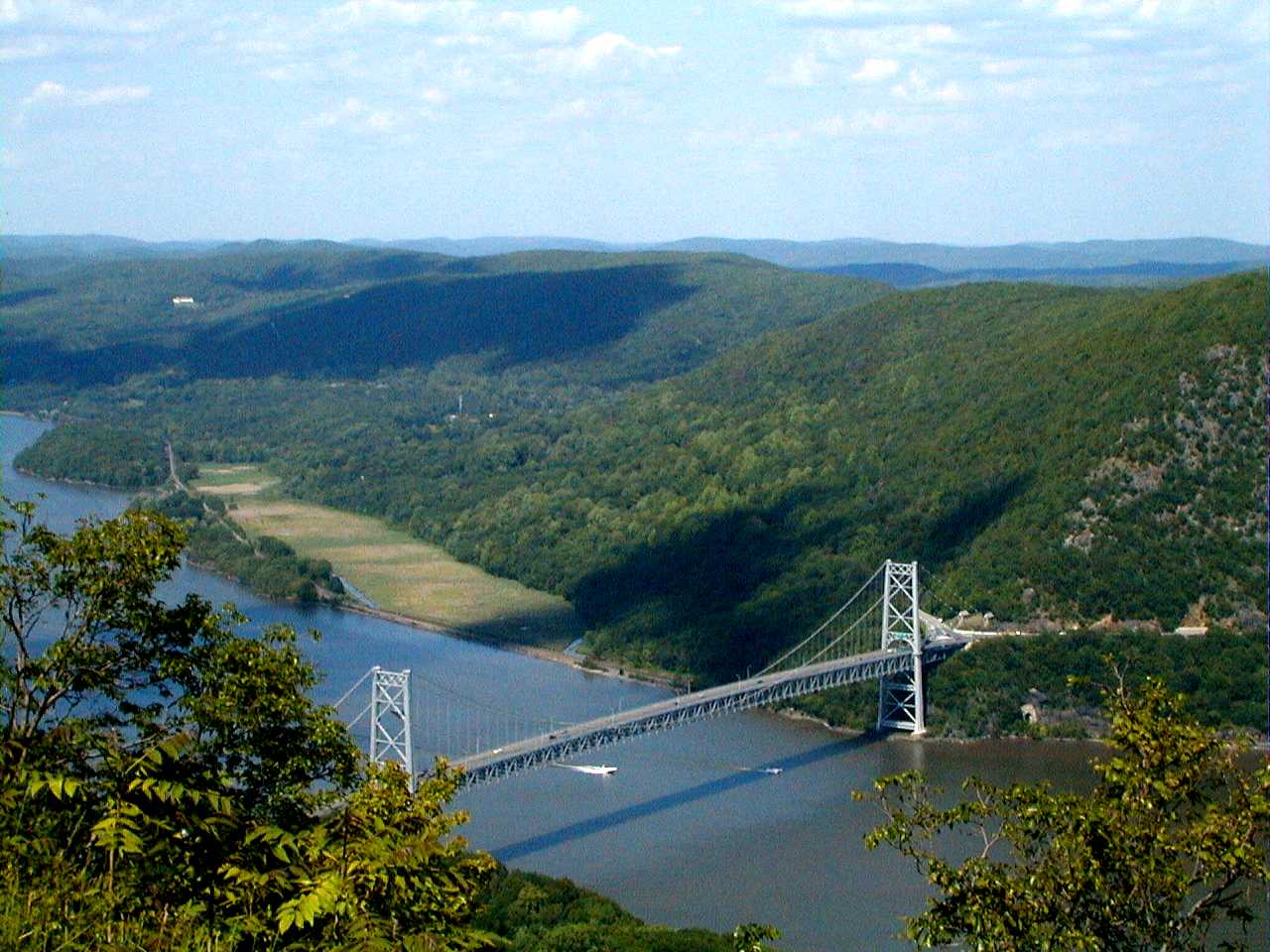
 Bear Mountain Bridge
New York's 88 miles (142 km) of trail[15] contain very little elevation change compared to other states. It is rather rugged terrain nonetheless, with many short though nearly-vertical ledges and small cliffs. From south to north, the trail summits many small mountains under 1,400 feet (430 m) in elevation, its highest point in New York being Prospect Rock at 1,433 feet (438 m), and less than half a mile (800 m) from the border with New Jersey. The trail continues north, climbing near Fitzgerald Falls, passing through Sterling Forest State Park, and then entering Harriman State Park and Bear Mountain State Park. In Harriman State Park, the trail passes through the famous Lemon Squeezer, a narrow crack between huge boulders. It crosses the Hudson River on the Bear Mountain Bridge, which is the lowest point on the entire Appalachian Trail at 124 feet (38 m). It then passes through Fahnestock State Park and continues northeast and crosses the Metro-North Railroad's Harlem Line at Pawling, which is also the only train station along the length of the trail. It enters Connecticut via the Pawling Nature Reserve. The section of the trail that passes through Harriman and Bear Mountain State Parks is the oldest section of the trail, completed in 1923.
Professional trail builder Eddie Walsh and Edward Goodell (Executive Director of the New York-New Jersey Trail Conference) oversaw and coordinated the construction of a paved trail coming off of Bear Mountain.[16] That portion of the Trail is composed of 800 steps made of 1,000-pound slabs of granite followed by over a mile of walkway supported by stone crib walls with boulders called gargoyles lining the path.[16] The project took four years, cost roughly $1 million, and was executed by about 700 volunteers. It officially opened in June 2010.[16]
Connecticut
Counties crossed: Litchfield County → Fairfield County
The 53 miles (84 km) of trail in Connecticut[17] lie almost entirely along the ridges to the west above the Housatonic River Valley. The trail climbs ridges below the town of Kent, and then works its way past the Housatonic River to Falls Village, where it regains the heights. After the town of Salisbury, the trail ascends into the Taconic Range, in order: Lions Head, Riga Ridge, and Bear Mountain, after which the Massachusetts line is achieved at Sage's Ravine.
The trail passes within one mile (1.6 km) of the business district of Kent, a popular resupply point for long-distance hikers. In the town of Salisbury (which occupies the northwestern corner of the state), it skirts the town center before reaching the summit of Bear Mountain, the highest peak in Connecticut at 2,326 feet (709 m), descending, and entering Massachusetts. (The state's highest point, on the shoulder of Mount Frissell at the Massachusetts line, lies about 2 miles (3 km) off the AT, just east of the junction of those two states with New York. Such a side-trip is on the order of 5 miles (8 km) long and entails about 1,300 vertical feet (400 m) of climbing.)
Massachusetts
County crossed: Berkshire County
 view from Mount Greylock in Massachusetts
Massachusetts has 90 miles (145 km) of trail.[18] The entire section of trail is in western Massachusetts' Berkshire County; it traverses both the Taconic Mountains and the Berkshires. The A.T. climbs the highest peak in the southern Taconic Mountains, Mount Everett (2,602 feet, 793 m), then descends to the Housatonic River Valley and skirts the town of Great Barrington. From there, it ascends into the Berkshire Mountains and passes through the towns of Dalton and Cheshire. It ascends into the Taconic Mountains again, visiting the highest point in the state at 3,491 feet (1064 m), Mount Greylock. It then quickly descends to the valley within 2 miles (3 km) of North Adams and Williamstown, before ascending again to the Vermont state line. The trail throughout Massachusetts is maintained by the Berkshire Chapter of the Appalachian Mountain Club.
Vermont
Counties crossed: Orange County →Windsor County →Addison County →Rutland County →Bennington County
Vermont has 150 miles (241 km) of the trail.[19] Upon entering Vermont, the trail coincides with the southernmost sections of the generally north/south-oriented Long Trail (which is subject to a request by its maintainers to protect it in its most vulnerable part of the year by forgoing spring hiking). It follows the ridge of the southern Green Mountains, summiting such notable peaks as Stratton Mountain, Glastenbury Mountain and Killington Peak. The trail traverses the Glastenbury, Lye Brook, and Peru Peak Wilderness areas. After parting ways with the Long Trail at Maine Junction, the AT turns in a more eastward direction, crossing the White River, passing through Norwich, and entering Hanover, New Hampshire, as it crosses the Connecticut River. In Vermont, The Green Mountain Club maintains the AT from the Massachusetts state border to Route 12. The Dartmouth Outing Club maintains the trail from Route 12 to the New Hampshire state line.
The NPS challenged Killington and Pico ski resorts in Vermont over development of private land that crossed the AT.[20]
New Hampshire
Counties crossed: Coos County →Carroll County →Grafton County
 View from the dutch door of the outhouse at Velvet Rocks shelter showing fall foliage
New Hampshire has 161 miles (259 km) of the trail.[21] The New Hampshire AT is nearly all within the White Mountain National Forest. The easier southern portion of the trail, from Hanover to Glencliff, passes over Velvet Rocks, Moose Mountain, Smarts Mountain, and Mount Cube. It then ascends Mount Moosilauke and enters the high peaks region of the Whites. For northbound thru-hikers, it is the beginning of the main challenges that go beyond enduring distance and time: in New Hampshire and Maine, rough or steep ground are more frequent, and alpine conditions are found near summits and along ridges.
The trail runs completely above treeline from the summit of Mount Pierce to the north side of the cone of Mt. Madison, a distance of about 12 miles (19 km). The AT passes over the summits of 16 of the 48 four-thousand footers of New Hampshire: Moosilauke, South and North Kinsman, Lincoln, Lafayette, Garfield, South Twin, Jackson, Pierce, Washington (the highest point of the AT north of Tennessee), Madison, Wildcats D and A, Carter Dome, South and Middle Carter. It comes close to the summits of 8 other of the 48 four-thousand footers: Liberty, Galehead, Zealand, Eisenhower, Monroe, Jefferson, Adams, and Moriah. A series of comfortable huts is maintained along parts of the NH trail by the Appalachian Mountain Club. In New Hampshire, the Dartmouth Outing Club maintains the AT from the Vermont border to Mount Moosilauke, with the AMC maintaining the remaining miles through the state. The trail passes through the towns of Hanover and Gorham, which have grocery stores and are accessible by public transportation (Dartmouth Coach and Concord Trailways) from Boston. Concord Trailways also has bus service to Lincoln (several miles off the AT) and AMC Pinkham Notch. During the summer season, AMC runs a shuttle service to Crawford Notch and Franconia Notch.
A tradition of thru-hikers Mooning the Cog has developed on Mount Washington.[22][23]
Maine
Counties crossed: Piscataquis County → Somerset County → Franklin County → Oxford County

The Appalachian Trail Conservancy (or ATC) believes the 281 miles (452 km) of the trail in Maine are particularly difficult.[24] The western section includes a mile-long (1.6 km) stretch of boulders at Mahoosuc Notch, often called the trail's hardest mile. The central Maine section crosses of the Kennebec River at a point where it is 200 feet (65 m) wide, the widest unbridged stream along the trail. The last and most isolated portion in the state (and arguably on the entire trail) is known as the "100-Mile Wilderness." This section heads east-northeast from the town of Monson and ends outside Baxter State Park just south of Abol Bridge. More moose are seen by hikers in this state than any other on the trail. The northern terminus of the Appalachian Trail is on Katahdin's Baxter Peak in Baxter State Park.
Baxter State Park closes the summer rules overnight camping season from October 15 to May 15 each year. Park management strongly discourages thru-hiking within the park before May 31 or after October 15.[25] The AMC maintains the AT from the New Hampshire border to Grafton Notch, with the Maine Appalachian Trail Club responsible for maintaining the remaining miles to Katahdin.
Beginning in the late 1980s, The NPS and ATC challenged the Saddleback Mountain resort in Maine over development of private land that crossed the AT.[20] The dispute continued a decade later, and after a June 1996 meeting between the two sides, NPS and ATC relented from some of their previous positions and reduced their proposed land-acquisition corridor by 70 percent. Even so, they remained opposed to any ski trails crossing the Trail in the alpine area.[26] Saddleback responded that further negotiations were unnecessary and the NPS began appraising if the area was feasible for development.[26]
See also
References
- ^ "A.T. Essentials". Appalachian Trail Conservancy. http://www.appalachiantrail.org/site/c.jkLXJ8MQKtH/b.727749/k.91A1/AT_Essentials.htm. Retrieved 2007-07-13.
- ^ "Explore the Trail: Georgia". Appalachian Trail Conservancy. http://www.appalachiantrail.org/georgia. Retrieved 2007-07-13.
- ^ "Explore the Trail: North Carolina". Appalachian Trail Conservancy. http://www.appalachiantrail.org/northcarolina. Retrieved 2007-07-13.
- ^ http://www.aldha.org/company/ga-tn10.pdf
- ^ Nickens, T. Edward (July 2001), "Bed and Breakfast". Smithsonian. 32 (4):24
- ^ "Explore the Trail: Tennessee". Appalachian Trail Conservancy. http://www.appalachiantrail.org/tennessee. Retrieved 2007-07-13.
- ^ "Explore the Trail: Virginia". Appalachian Trail Conservancy. http://www.appalachiantrail.org/virginia. Retrieved 2007-07-13.
- ^ Metz, Casey (May/June 2007), "Appalachian Trail Tidbit". National Geographic Traveler. 24 (4):159
- ^ Collier, Christopher Percy (May 12, 2006), "Good Times at a Backpackers' Paradise". New York Times. 155 (53577):D1-D5
- ^ "Explore the Trail: West Virginia". Appalachian Trail Conservancy. http://www.appalachiantrail.org/westvirginia. Retrieved 2007-07-13.
- ^ "xplore the Trail: Maryland". Appalachian Trail Conservancy. http://www.appalachiantrail.org/maryland. Retrieved 2007-07-13.
- ^ "Explore the Trail: Pennsylvania". Appalachian Trail Conservancy. http://www.appalachiantrail.org/pennsylvania. Retrieved 2007-07-13.
- ^ C., K. (July/August 1984), "Appalachian Trail Route Challenged". National Parks. 58 (7/8):41
- ^ "Explore the Trail: New Jersey". Appalachian Trail Conservancy. http://www.appalachiantrail.org/newjersey. Retrieved 2007-07-13.
- ^ "Explore the Trail: New York". Appalachian Trail Conservancy. http://www.appalachiantrail.org/newyork. Retrieved 2007-07-13.
- ^ a b c APPLEBOME, PETER (May 31, 2010), "A Jolt of Energy for a Much Trod-Upon Trail". New York Times. :p14
- ^ "Explore the Trail: Connecticut". Appalachian Trail Conservancy. http://www.appalachiantrail.org/connecticut. Retrieved 2007-07-13.
- ^ "Explore the Trail: Massachusetts". Appalachian Trail Conservancy. http://www.appalachiantrail.org/massachusetts. Retrieved 2007-07-13.
- ^ "Explore the Trail: Vermont". Appalachian Trail Conservancy. http://www.appalachiantrail.org/vermont. Retrieved 2007-07-13.
- ^ a b Knize, P. (January 1990), "Trails and tribulations". Skiing. 42 (5):2E
- ^ "Explore the Trail: New Hampshire". Appalachian Trail Conservancy. http://www.appalachiantrail.org/newhampshire. Retrieved 2007-07-13.
- ^ http://www.wlbz2.com/news/article.aspx?storyid=74791
- ^ Zezima, Katie (2007-11-23). "Riding the Rail to the Top, and Not Amused". The New York Times. http://www.nytimes.com/2007/11/23/us/23cog.html?ex=1353474000&en=a7f41d3afce4fbf9&ei=5088&partner=rssnyt&emc=rss. Retrieved 2010-04-25.
- ^ "Explore the Trail: Maine". Appalachian Trail Conservancy. http://www.appalachiantrail.org/maine. Retrieved 2007-07-13.
- ^ http://www.baxterstateparkauthority.com/hiking/thru-hiking.html
- ^ a b Holmstrom, David (June 6, 1997), "Path with a view is center of Maine ski resort dispute". Christian Science Monitor. 89 (134):
Further reading
- Stroh, Bess Zarafonitis (September/October 1998), "Colorful climbs". National Parks. 72 (9/10):34-37
- Bryson, Bill. "A Walk in the Woods". Doubleday, 1997. Black Swan Publishing, 1998.
Hiking Trails in Pennsylvania 202 • Appalachian • Baker • Black Forest • Brandywine • Bucktail Path • Chester Valley • Chuck Keiper • Conestoga • Cresheim • Cross County • Darlington • Donut Hole • Evansburg • Forbes Road • GAP • GET • Glacier Ridge • Golden Eagle • Horse Shoe • John P. Saylor • Laurel Highlands • Liberty Bell • Lost Turkey • Lower • Loyalsock • Mason-Dixon • Mid State • Mill Creek • Montour • North Country • Old Loggers Path • Panhandle • Pennypack • Perkiomen • Pinchot • Potomac Heritage • Power Line • Quebec Run • Quehanna • Rachel Carson • Rock Run • Schuylkill East • Schuylkill River • Standing Stone • Struble • Susquehannock • Tanbark • Terrace Mountain • Thunder Swamp • Tuscarora • Valley Forge • Warrior • West County • West Rim • Wissahickon • Youghiogheny River
 Categories:
 -


Wikimedia Foundation. 2010.