Salhad

Salhad

Union Councils
name = Salhad


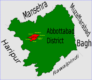
caption = Location of Salhad Union Council (highlighted in red) within Abbottabad District, the names of neighbouring districts to Abbottabad are also shown
province = NWFP
district = Abbottabad
tehsil = Abbottabad Tehsil
nazim = Shaukat Ali Tanoli [http://www.abbottabad.gov.pk/Union-council/UCDetailPage.asp?name=Salhad Salhad Union Council] ]
naib nazim = Muhammad Ashraf
population = 21,211
coordinates =

Salhad is one of the 51 Union Councils (sub-divisions) of Abbottabad District in the North-West Frontier Province of Pakistan [ [http://www.abbottabad.sdnpk.org/adminunit.htm Administrative Units of District Abbottabad] ] .

The Union Council of Salhad is named after what was the main village of the area, but has now effectively become a suburb of Abbottabad city.

It is situated about two kilometres south of the current city limits of Abbottabad.

Population

The population of the town is now over 21,000 [ [http://www.abbottabad.sdnpk.org/list_administrative.htm List of Union Councils District & Tehsil Abbottabad] ] .

ubdivisions

Salhad Union Council is subdivided into two areas Salhad and Khokar.

References


Wikimedia Foundation. 2010.

Игры ⚽ Поможем написать курсовую

Look at other dictionaries:

  • Salhad — est l une des 51 subdivisions du district d Abbottabad de la province de la Frontière du Nord Ouest, au Pakistan[1]. Références ↑ (en) …   Wikipédia en Français

  • Abbottabad District — Abottabad District   District   Map of Hazara, Pakistan with Abbottabad District highlighted Country …   Wikipedia

  • Salkhad — arabisch ‏صلخد‎, DMG Ṣalḫad Salkhad …   Deutsch Wikipedia

  • Nathia Gali —   Union council   Location of Nathia Gali union council (highlighted in red) within Abbottabad district …   Wikipedia

  • Namli Maira —   Union council   Location of Namli Maira (highlighted in red) within Abbottabad district, the names of the neighbouring districts to Abbottabad are also shown …   Wikipedia

  • Dhamtour —   Union council   Dhamtore is located in Abbottabad District Coordinates …   Wikipedia

  • Nagri Totial — Nagri Tutial   Union council   Location of Nagri Tutial (highlighted in red) within Abbottabad district, the names of the neighbouring districts to Abbottabad are also shown …   Wikipedia

  • Dewal Manal —   Union council   Dewal Manal is located in Abbottabad District Country …   Wikipedia

  • Langra, NWFP — Union Councils name = Langra caption = Langra is located in Abbottabad District province = NWFP district = Abbottabad tehsil = Havelian nazim = Waqar Ahmed Khan [http://www.abbottabad.gov.pk/Union council/UCDetailPage.asp?name=Langra Langra Union …   Wikipedia

  • Chamhad — Chamad   Union Council   Chamad is located in Abbottabad District Coordinates …   Wikipedia

Share the article and excerpts

Direct link
Do a right-click on the link above
and select “Copy Link”