- Otsego County, New York
-
Otsego County, New York 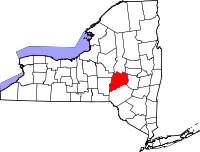
Location in the state of New York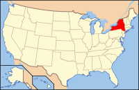
New York's location in the U.S.Founded February 16, 1791 Seat Cooperstown Largest city Oneonta Area
- Total
- Land
- Water
1,015 sq mi (2,629 km²)
1,003 sq mi (2,598 km²)
12 sq mi (31 km²), 1.21%Population
- (2010)
- Density
62,259
62/sq mi (23.9/km²)Website www.otsegocounty.com Otsego County is a county located in the U.S. state of New York. The 2010 population was 62,259. The county seat is Cooperstown. The name Otsego is from a Mohawk word meaning "place of the rock."
Contents
History
- For History of Otsego County before 1789 see Montgomery County.
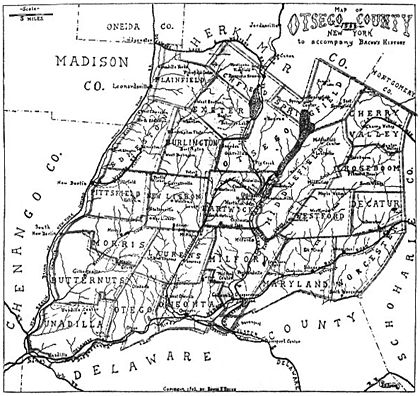
 Map of Otsego County, at its formation
 Map of Otsego County, New York, by Simeon De Witt c. 1792-1793
 1829 map of Otsego County, New York
In 1789, Ontario County was split off from Montgomery. The area split off from Montgomery County was much larger than the present county, as it included the present Allegany, Cattaraugus, Chautauqua, Erie, Genesee, Livingston, Monroe, Niagara, Orleans, Steuben, Wyoming, Yates, and part of Schuyler and Wayne counties.
The formation of Otsego County
Otsego County was one of three counties split off from Montgomery (the other two being Herkimer, and Tioga). Otsego County was officially established on February 16, 1791, with Cooperstown as its county seat, although at the time the village of Cherry Valley was much larger. The original county consisted of three large townships:
- Cherry Valley in the northeast,
- Otsego in the northwest, and
- Harpersfield in the south.
Otsego and Cherry Valley together roughly covered the area of modern Otsego County, while Harpersfield covered the area south of the current county as far as the Delaware River.
The original appointments to Otsego County government positions, made by Governor George Clinton included:
- Richard R. Smith, county sheriff, from Otsego township,
- Jacob Morris, county clerk, from Otsego township,
- William Cooper, chief judge, from Otsego township,
- Jedediah Peck, associate justice from Otsego township,
- Edward Griswold, associate justice from Cherry Valley
- Platt Townsend, associate justice from Harpersfield,
- Alexander Harper, commander of the county militia, from Harpersfield.
The founding of new towns
By 1793, four towns had been added to the county by division of the existing towns:
- The Otsego township had been divided into the towns of:
- Burlington in the west,
- Otsego in the northeast,
- Richfield in the north, and
- Unadilla in the south.
- Harpersfield had been divided into the towns of:
- Franklin in the west and
- Harpersfield in the east.
Areas of Otsego County used to form new counties
The area of Otesgo County was reduced by a number of subsequent splits.
In 1795, a piece of Otsego County was joined with a portion taken from Albany County to create Schoharie County.
In 1797, a piece of Otsego County was joined with a portion taken from Ulster County to create Delaware County.
Geography
Otsego County is in central New York State, to the west of Albany, southeast of Utica, and northeast of Binghamton. The county is considered by some to belong to the Southern Tier region of New York State.
According to the 2000 census, the county has a total area of 1,015 square miles (2,630 km2), of which 1,003 square miles (2,600 km2) is land and 12 square miles (31 km2) (1.21%) is water.
Adjacent counties
- Herkimer County, New York - north
- Montgomery County, New York - northeast
- Schoharie County, New York - east
- Delaware County, New York - south
- Chenango County, New York - southwest
- Oneida County, New York - northwest
- Madison County, New York - northwest
Economy
The Village of Cooperstown (home of James Fenimore Cooper), located at the south end of Otsego Lake, attracts many tourists to the Baseball Hall of Fame and the New York State Historical Association museums. Its primary industry is healthcare as it is home to Bassett Medical Center, the headquarters of Bassett Healthcare Network and its more than 2,000 employees. The City of Oneonta is the home of Hartwick College, the State University of New York at Oneonta, A.O. Fox Memorial Hospital, major retail activity, and numerous small businesses. The county as a whole remains relatively rural, with dairy farming a contributing industry that has consolidated employment in recent years, although production has remained steady.
Demographics
Historical populations
of Otsego CountyYear Population 1790 1800 21,343 1810 38,802 1820 44,856 1830 51,372 1840 49,628 1850 48,638 1860 50,157 1870 48,967 1880 51,397 1890 50,861 Year Population 1900 48,939 1910 47,216 1920 46,200 1930 46,710 1940 46,082 1950 50,763 1960 51,942 1970 56,181 1980 59,075 1990 60,517 2000 61,676 2010 62,259 As of the census[1] of 2000, there were 61,676 people, 23,291 households, and 15,115 families residing in the county. The population density was 62 people per square mile (24/km²). There were 28,481 housing units at an average density of 28 per square mile (11/km²). The racial makeup of the county was 95.80% White, 1.75% African American, 0.23% Native American, 0.63% Asian, 0.05% Pacific Islander, 0.50% from other races, and 1.05% from two or more races. Hispanic or Latino of any race were 1.90% of the population. 15.0% were of Irish, 14.9% English, 14.9% German, 11.3% Italian and 9.1% American ancestry according to Census 2000. 95.4% spoke English and 2.1% Spanish as their first language.
There were 23,291 households out of which 29.60% had children under the age of 18 living with them, 51.10% were married couples living together, 9.50% had a female householder with no husband present, and 35.10% were non-families. 27.00% of all households were made up of individuals and 11.60% had someone living alone who was 65 years of age or older. The average household size was 2.43 and the average family size was 2.94.
In the county the population was spread out with 22.70% under the age of 18, 14.40% from 18 to 24, 24.30% from 25 to 44, 23.60% from 45 to 64, and 15.00% who were 65 years of age or older. The median age was 37 years. For every 100 females there were 93.10 males. For every 100 females age 18 and over, there were 90.00 males.
The median income for a household in the county was $33,444, and the median income for a family was $41,110. Males had a median income of $29,988 versus $22,609 for females. The per capita income for the county was $16,806. About 8.80% of families and 14.90% of the population were below the poverty line, including 15.80% of those under age 18 and 8.20% of those age 65 or over.
Government and politics
Otsego county is a true swing county; it has chosen the winner of the presidency for the last three decades. In 2004 Otsego County voted 51-48 percent in favor of George W. Bush, and in 2008 they voted 51-47 in favor of Barack Obama. Democrats are prevalent in the City of Oneonta and Village of Cooperstown and Republicans are registered as a majority of voters in many of the surrounding towns.
Towns, Villages and Cities
See also
- List of counties in New York
- National Register of Historic Places listings in Otsego County, New York
References
- ^ "American FactFinder". United States Census Bureau. http://factfinder.census.gov. Retrieved 2008-01-31.
External links
- Otsego County Tourism
- Official Otsego County Government Site
- Otsego County at the Open Directory Project
- Lyman H. Butterfield, "Cooper's Inheritance: The Otsego Country and its Founders", New York History, Vol. 35, No. 4 (October, 1954), pp. 374-411.
- "Otsego County"[dead link]
- J. H. French, "OTSEGO COUNTY", GAZETTEER OF THE STATE OF NEW YORK, Syracuse, New York: R. Pearsall Smith, 1860
- Boy Scout Camp Serving County - Henderson Scout Reservation

Oneida County and Madison County Herkimer County Montgomery County 
Schoharie County  Otsego County, New York

Chenango County Delaware County Municipalities and communities of Otsego County, New York City 
Towns Burlington | Butternuts | Cherry Valley | Decatur | Edmeston | Exeter | Hartwick | Laurens | Maryland | Middlefield | Milford | Morris | New Lisbon | Oneonta | Otego | Otsego | Pittsfield | Plainfield | Richfield | Roseboom | Springfield | Unadilla | Westford | Worcester
Villages Cherry Valley | Cooperstown | Gilbertsville | Laurens | Milford | Morris | Otego | Richfield Springs | Unadilla
CDP Other
hamletsBurlington Flats | Schenevus | Schuyler Lake | Silver Lake | South Edmeston | West Burlington | West Edmeston‡
Footnotes ‡This populated place also has portions in an adjacent county or counties
Categories:- New York counties
- Otsego County, New York
- 1791 establishments
- Catskills


Wikimedia Foundation. 2010.