- Orleans County, New York
-
Orleans County, New York 
Seal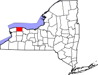
Location in the state of New York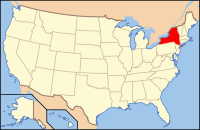
New York's location in the U.S.Founded 1824 Seat Albion Area
- Total
- Land
- Water
817 sq mi (2,116 km²)
391 sq mi (1,013 km²)
426 sq mi (1,103 km²), 52.12%Population
- (2010)
- Density
42,883
110/sq mi (42.3/km²)Website www.orleansny.com Orleans County is a county located in the U.S. state of New York. As of the 2010 census, the population was 42,883. The county seat is Albion. The name is in honor of the French Royal House of Orleans.
Orleans County is part of the Rochester, NY Metropolitan Statistical Area.
Contents
History
When counties were established in New York State in 1683, the present Orleans County was part of Albany County. This was an enormous county, including the northern part of New York State as well as all of the present State of Vermont and, in theory, extending westward to the Pacific Ocean. This county was reduced in size on July 3, 1766 by the creation of Cumberland County, and further on March 16, 1770 by the creation of Gloucester County, both containing territory now in Vermont.
On March 12, 1772, what was left of Albany County was split into three parts, one remaining under the name Albany County. One of the other pieces, Tryon County, contained the western portion (and thus, since no western boundary was specified, theoretically still extended west to the Pacific). The eastern boundary of Tryon County was approximately five miles west of the present city of Schenectady, and the county included the western part of the Adirondack Mountains and the area west of the West Branch of the Delaware River. The area then designated as Tryon County now includes 37 counties of New York State. The county was named for William Tryon, colonial governor of New York.
In the years prior to 1776, most of the Loyalists in Tryon County fled to Canada. In 1784, following the peace treaty that ended the American Revolutionary War, the name of Tryon County was changed to Montgomery County in order to honor the general, Richard Montgomery, who had captured several places in Canada and died attempting to capture the city of Quebec, replacing the name of the hated British governor.
In 1789, Ontario County was split off from Montgomery.
In 1802, Genesee County was created by a splitting of Ontario County . This was much larger than the present Genesee County, however, containing the present Allegany, Cattaraugus, Chautauqua, Erie, Niagara, Orleans, and Wyoming Counties, and parts of Livingston and Monroe Counties.
In 1806, Genesee County was reduced in size by the splitting off of Allegany County. In 1808, Genesee County was further reduced in size by the splitting off of Cattaraugus, Chautauqua, and Niagara Counties. Niagara County at that time also included the present Erie County.
In 1821, Genesee County was reduced in size by the splitting off of portions which were combined with portions of Ontario County to create Livingston and Monroe Counties. By this time Genesee County had been reduced considerably in size from its original area of 1802, still containing the present Orleans and Wyoming Counties in addition to its present area, however.
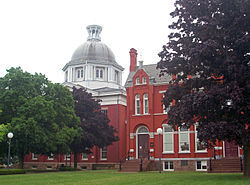 County courthouse and clerk's office in Albion
In 1824, Orleans County was created from what was left of Genesee County.
Geography
According to the U.S. Census Bureau, the county has a total area of 817 square miles (2,120 km2), of which 391 square miles (1,010 km2) is land and 426 square miles (1,100 km2) (52.12%) is water. The high proportion of water is due to the extension of Orleans County north into Lake Ontario to the Canadian border (a line of latitude running through the middle of the lake). The distance from the Orleans shore north to the international border is greater than the distance from the shore south to the Genesee County line, meaning the area of Orleans underwater is actually greater than that above water.
Orleans County is in western New York State, northeast of Buffalo and west of Rochester, on the southern shore of Lake Ontario.
The Erie Canal passes (east-west) through the middle of the county.
Adjacent counties
- Monroe County - east
- Genesee County - south
- Niagara County - west
Major highways
 New York State Route 18
 New York State Route 31
 New York State Route 63
 New York State Route 98
 New York State Route 104
 Lake Ontario State Parkway
National protected area
Demographics
Historical populations Census Pop. %± 1830 17,732 — 1840 25,127 41.7% 1850 28,501 13.4% 1860 28,717 0.8% 1870 27,689 −3.6% 1880 30,128 8.8% 1890 30,803 2.2% 1900 30,164 −2.1% 1910 32,000 6.1% 1920 28,619 −10.6% 1930 28,795 0.6% 1940 27,760 −3.6% 1950 29,832 7.5% 1960 34,159 14.5% 1970 37,305 9.2% 1980 38,496 3.2% 1990 41,846 8.7% 2000 44,171 5.6% 2010 42,883 −2.9% [1] As of the census[2] of 2000, there were 44,171 people, 15,363 households, and 10,846 families residing in the county. The population density was 113 people per square mile (44/km²). There were 17,347 housing units at an average density of 44 per square mile (17/km²). The racial makeup of the county was 89.12% White, 7.31% Black or African American, 0.46% Native American, 0.32% Asian, 0.03% Pacific Islander, 1.54% from other races, and 1.21% from two or more races. 3.89% of the population were Hispanic or Latino of any race. 20.3% were of German, 18.3% English, 10.8% Italian, 10.3% Irish, 9.4% American and 7.3% Polish ancestry according to Census 2000. 96.0% spoke English and 3.0% Spanish as their first language.
There were 15,363 households out of which 35.0% had children under the age of 18 living with them, 54.3% were married couples living together, 11.2% had a female householder with no husband present, and 29.4% were non-families. 23.7% of all households were made up of individuals and 10.7% had someone living alone who was 65 years of age or older. The average household size was 2.65 and the average family size was 3.13.
In the county the population was spread out with 26.2% under the age of 18, 8.2% from 18 to 24, 31.3% from 25 to 44, 21.9% from 45 to 64, and 12.40% who were 65 years of age or older. The median age was 36 years. For every 100 females there were 98.3 males. For every 100 females age 18 and over, there were 95.2 males.
The median income for a household in the county was $37,972, and the median income for a family was $42,830. Males had a median income of $32,450 versus $22,605 for females. The per capita income for the county was $16,457. About 7.7% of families and 10.8% of the population were below the poverty line, including 15.0% of those under age 18 and 5.2% of those age 65 or over.
Towns and villages
 The town and village borders
- Albion (village)
- Albion (town)
- Barre (town)
- Carlton (town)
- Clarendon (town)
- Gaines (town)
- Holley (village)
- Kendall (town)
- Lyndonville (village)
- Medina (village)
- Murray (town)
- Ridgeway (town)
- Shelby (town)
- Yates (town)
- label in parentheses refers to official category of political entity.
Federal and state lands
- Iroquois National Wildlife Refuge
- Lakeside Beach State Park
- Oak Orchard State Marine Park
- Oak Orchard Wildlife Management Area
- Tonawanda Wildlife Management Area
Educational institutions
The county is considered to have five school districts, although the actual district boundaries can extend into neighboring counties, and the same is true for neighboring counties' districts. The five districts, from west to east, are:
- Lyndonville Central School District (northern half of western third, roughly covering Lyndonville village and the towns of Yates and Ridgeway)
- Medina Central School District (southern half of western third, roughly covering Medina village and the towns of Ridgeway and Shelby)
- Albion Central School District (middle third, roughly covering Albion village and the towns of Carlton, Gaines, Albion, and Barre)
- Kendall Central School District (northern half of eastern third, roughly covering the towns of Kendall and Murray)
- Holley Central School District (southern half of eastern third, roughly covering Holley village and the towns of Murray and Clarendon)
The only post-secondary education available in the county are two branches of Genesee Community College located in Albion and Medina.
Additional information
When the county was formed, a dispute arose about naming it after Andrew Jackson or John Adams; the conflict was ended by choosing the name Orleans.
The Erie Canal Culvert near Medina is the only roadway that passes under the Erie Canal.
See also
- Orleans County Sheriffs Office
- List of fire departments in Orleans County, New York
- List of counties in New York
- National Register of Historic Places listings in Orleans County, New York
References
- ^ http://factfinder2.census.gov
- ^ "American FactFinder". United States Census Bureau. http://factfinder.census.gov. Retrieved 2008-01-31.
External links
- Official Webpage
- Orleans County at the Open Directory Project
- Orleans County travel guide from Wikitravel
- Genesee Community College in Orleans County
- Brief historical summary of Orleans County, NY

Lake Ontario Niagara County 
Monroe County  Orleans County, New York

Erie County Genesee County Municipalities and communities of Orleans County, New York Towns 
Villages Albion | Holley | Lyndonville | Medina
Hamlets Barre Center | Childs | Millville | Oak Orchard
Categories:- New York counties
- Orleans County, New York
- 1824 establishments in the United States
- Populated places established in 1824
- Rochester, New York metropolitan area


Wikimedia Foundation. 2010.