- Mucking
-
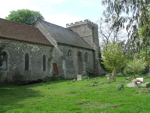
 Former church of St John the Baptist, Mucking, Essex
Mucking is a hamlet and former Church of England parish adjoining the Thames estuary in southern Essex, England. It is located approximately 2 miles south of the town of Stanford le Hope in what is now Thurrock unitary authority.
Contents
Early history
Mucking was "a particularly extensive Anglo-Saxon settlement, of at least 100+ individuals, commanding an important strategic position in the Lower Thames region; it may have functioned as a meeting place and mart for surrounding areas on both sides of the Thames".[1] Its name is of Saxon origin and indicates human settlement here for well over a millennium. The meaning is usually given as 'the family (or followers) of Mucca' (Mucca most likely being a local chieftain). However, Margaret Gelling has suggested alternative interpretations - 'Mucca's place' or 'Mucca's stream'[2]. Mucking's geographical location on flat marshland at the very mouth of the River Thames indicates that settlement in the area by Germanic invaders from the Continent probably occurred at a relatively early date; indeed, an outline of a now abandoned nearby Saxon village, West Mucking, was discovered from aerial photographs in the 20th century. Mucking was host to a small iron smelting industry because of its workable deposits of iron ore[3]. Spongy iron blooms were produced and had their impurities worked out by a process known as 'Mucking'[4]. It is not known if this process is connected to the village name or a coincidence.
Modern Mucking
Although the population of the hamlet is now less than one hundred, it thrived in Victorian times, boasting small shops, a large rectory and the mediaeval church of St John the Baptist (both of the latter buildings have now been converted to private houses, with access to the church graveyard possible only with prior written permission). The hamlet also gives its name to Mucking Flats, the mudflat on the estuary to the east of the village, one of Essex's Sites of Special Scientific Interest and once the site of a small lighthouse.
The Mucking Archeological Excavation
Main article: The Mucking ExcavationMucking was the location for a major archeological dig ahead of excavation from the gravel quarry that swallowed it up. The site was discovered by crop marks in the soil photographed by Dr St Joseph in 1959. The excavation was directed by Margaret Jones and lasted from 1965 to 1978. In addition to major finds from the Saxon period, other artefacts from the site span the period from the Stone Age through to the medieval period.[5]
The Saxon settlement excavated at Mucking was extensive with more than 230 buildings. The site contained two cemeteries[6]. Many of the buildings were sunken huts although there were timber halls which were possibly occupied by the higher status families. The settlement gradually moved north over the course of two hundred years after its establishment in the fourth century.
Parish church
The parish church was dedicated to St John the Baptist. It was largely demolished and rebuilt in the middle of the 19th century.[7] It is now redundant and used as private dwelling.[8]
Mucking Marshes Landfill Site
Main article: Mucking Marshes LandfillNotes
- ^ Sue Hirst and Dido Clark, Excavations at Mucking: Volume 3, The Anglo-Saxon Cemeteries (Museum of London Archaeology 2009)
- ^ Margaret Gelling, The Place-name Mucking (in Excavations at Mucking, Volume 2, English Heritage, 1993, page 96)
- ^ Tylecote, RF, 1986, The Prehistory of Metallurgy in the British Isles. Institute of Metals London.
- ^ Morton, GR, & Brit, R,G.,1974-75 The Present Day Production of Wrought Iron. Journal of the Historical Metallurgy Society.
- ^ M U Jones, Mucking and the early Saxon rural settlement in Essex (in D G Buckley (Editor), Archaeology in Essex to AD 1500)
- ^ Nigel Brown (compiler), Splendid and Permanent Pageants, Essex County Council, 2000
- ^ Buckler, George (1856). Twenty-two of the churches of Essex architecturally described and illustrated. p. 60.
- ^ Andrew Barham, Lost Parish Churches of Essex (Ian Henry Publications, 2000
Thurrock Traditional Parishes in Thurrock Aveley · Bulphan · Chadwell St Mary · Corringham · East Tilbury · Fobbing · Grays · Horndon-on-the-Hill · Little Thurrock · Mucking · Orsett · South Ockendon · Stanford-le-Hope · Stifford · West Thurrock · West TilburyOther places in Thurrock Baker Street · Biggin, Essex · Bill Meroy Creek · Chafford Hundred · Hangman's Wood · Lower Horse · Mardyke (river) · Orsett Heath · Purfleet · Rainham Marshes Nature Reserve · Shell Haven · Terrel's Heath · Tilbury TownExternal links
Categories:- Thurrock
- Hamlets in Essex
- Places in Essex listed in the Domesday Book
Wikimedia Foundation. 2010.