- Cornwall and West Devon Mining Landscape
-
Cornwall and West Devon Mining Landscape * UNESCO World Heritage Site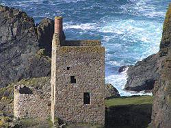
Part of Crown Mines, BotallackCountry United Kingdom Type Cultural Criteria ii, iii, iv Reference 1215 Region ** Europe and North America Inscription history Inscription 2006 (30th Session) * Name as inscribed on World Heritage List
** Region as classified by UNESCOThe Cornwall and West Devon Mining Landscape is a World Heritage Site which includes select mining landscapes across Cornwall and West Devon in the south west of the United Kingdom. The site was added to the World Heritage List during the 30th Session of the UNESCO World Heritage Committee in Vilnius, July 2006.
Contents
History
Up to the mid-16th century, Devon produced approximately 25-40% of the amount of tin that Cornwall did but the total amount of tin production from both Cornwall and Devon during this period was relatively small. After the 1540s, Cornwall's production took off and Devon's production was only about between a ninth to a tenth of that of Cornwall. From the mid-16th century onwards, the Devon Stannaries were worth very little in income to the King and were sidelined as such following the Supremacy of Parliament Act 1512 (this does not apply to the Stannaries of Cornwall).
The landscapes of Cornwall and West Devon were radically reshaped during the 18th and 19th centuries by deep-lode mining for copper and tin. The underground mines, engine houses, foundries, new towns, smallholdings, ports, harbours, and ancillary industries together reflect prolific innovation which, in the early 19th century, enabled the region to produce two-thirds of the world's supply of copper. During the late 19th century, arsenic production came into ascendancy with mines in the east of Cornwall and West Devon supplying half the world’s demand.
 Tin mine in St Just, Cornwall
The early 19th century also saw a revolution in steam engine technology which was to radically transform hard-rock mining fortunes. The high-pressure expansively operated beam pumping engine developed by the engineers Richard Trevithick and Arthur Woolf enabled mining at much greater depths than had been possible hitherto. Cornish-design beam engines and other mining machinery was to be exported from major engineering foundries in Hayle, Perranarworthal, Tavistock and elsewhere to mining fields around the world throughout the century.
Commencing in the early 19th century, significant numbers of mine workers migrated to live and work in mining communities based on Cornish traditions, this flow reaching its zenith at the end of the 19th century. Today numerous migrant-descended Cornish communities flourish around the world and distinctive Cornish-design engine houses can be seen in Australia, New Zealand, South Africa, Mexico, the British Virgin Islands, Spain, and in the mining fields of other parts of England, Wales, Scotland, Ireland, the Channel Islands, and the Isle of Man.
A much reduced mining industry continued in Cornwall after the copper crash of the 1860s with production mainly focused on tin. Metalliferous mining finally ceased in Cornwall in 1998 with the closure of South Crofty Mine, Pool, the last tin mine to operate in Europe.
Areas
The World Heritage Site comprises discrete but thematically linked areas spanning Cornwall and West Devon. The areas (with the area codes from the site nomination) are:[1]
- A1 - St Just Mining District
- A2 - Port of Hayle
- A3i - Tregonning and Gwinear Mining District
- A3ii - Trewavas
- A4 - Wendron Mining District
- A5i - Camborne and Redruth Mining District
- A5ii - Wheal Peevor
- A5iii - Portreath Harbour
- A6i - Gwennap Mining District
- A6ii - Perran Foundry
- A6iii - Kennall Vale
- A7 - St Agnes Mining District
- A8i - Luxulyan Valley
- A8ii - Charlestown
- A9 - Caradon Mining District
- A10i - Tamar Valley
- A10ii - Tavistock
See also
- Stannary Courts and Parliaments
- Mining in Cornwall and Devon
- Revived Cornish Stannary Parliament
- Wheel Wreck
References
- ^ "The World Heritage Site Areas". Cornwall & Scilly Historic Environment Service. 2006. http://www.cornish-mining.org.uk/sites/sites.htm. Retrieved 25 May 2007.
External links
- UNESCO listing
- BBC - World Heritage site bid gets go-ahead
- World Heritage website
- Cornish Mining - World Heritage Status
World Heritage Sites in the United Kingdom England Bath · Blenheim Palace · Canterbury Cathedral, St. Augustine's Abbey and St. Martin's Church · Cornwall and West Devon Mining Landscape · Derwent Valley Mills · Durham Castle and Cathedral · Frontiers of the Roman Empire (Hadrian's Wall) · Ironbridge Gorge · Jurassic Coast · Kew Gardens · Liverpool Maritime Mercantile City · Maritime Greenwich · Saltaire · Stonehenge, Avebury and Associated Sites · Studley Royal Park and Fountains Abbey · Tower of London · Westminster Palace, Westminster Abbey and St. Margaret's Church
Scotland Wales Northern Ireland British Overseas Territories Geography of Cornwall Unitary authorities Major settlements Bodmin • Bude • Callington • Camborne • Camelford • Falmouth • Fowey • Hayle • Helston • Launceston • Liskeard • Looe • Lostwithiel • Marazion • Newlyn • Newquay • Padstow • Par • Penryn • Penzance • Porthleven • Redruth • Saltash • St Austell • St Blazey • St Columb Major • St Ives • St Just-in-Penwith • St Mawes • Stratton • Torpoint • Truro • Wadebridge
See also: Civil parishes in CornwallRivers Topics History • Status debate • Flag • Culture • Places • People • The Duchy • Diocese • Politics • Hundreds/shires • Places of interest • full list...Categories:- Geography of Cornwall
- Mining in Cornwall
- Geography of Devon
- History of Cornwall
- History of Devon
- World Heritage Sites in England
- History of mining


Wikimedia Foundation. 2010.