- Cooma, New South Wales
-
Cooma
New South Wales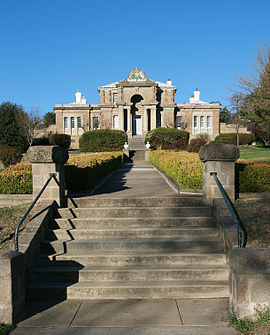
Cooma Court House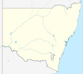
 Cooma
CoomaPopulation: 6,587(taken in 2006)[1] Postcode: 2630 Elevation: 800 m (2,625 ft) Location: LGA: Cooma-Monaro Shire County: Beresford State District: Monaro Federal Division: Eden-Monaro Mean max temp Mean min temp Annual rainfall 19.3 °C
67 °F4.1 °C
39 °F532.9 mm
21 inLocalities around Cooma: Adaminaby Bredbo Cooma Jindabyne and Berridale Nimmitabel Cooma is a town in the south of New South Wales, Australia. It is located 115 km south of the national capital, Canberra, via the Monaro Highway. It is also on the Snowy Mountains Highway, connecting Bega with the Riverina. The town has a population of 6,587.[1] Cooma is the main town of the Monaro region. It is 800 metres (2,620 ft) above sea level. The name could have derived from an Aboriginal word Coombah, meaning 'big lake' or 'open country'.[2]
Contents
History
Cooma was explored by Captain J.M. Currie in 1823. It was first surveyed in 1840 and it was proclaimed a municipality in 1879. The railway from Sydney was extended from Royalla to Cooma in 1889 and closed in 1986.[3][4] Its estimated population was 47 in 1851 and it grew to 2330 (1911), 1969 (1933), 2249 (1947), 9103 (1966), 7353 (1976) and 7978 (1981).[citation needed]
 Aviation Pioneers' Memorial at Cooma
In 1949, the town became the headquarters of the Snowy Mountains Scheme and grew rapidly.[citation needed] In 1959 the tenth anniversary of the scheme was celebrated with the erection of an avenue of flags representing the 27 nationalities of people working on the scheme.[citation needed]
Cooma has developed a growing tourism industry as it became the main rest stop for many travellers heading to the NSW snow fields during the winter months. As a result, the town nicknamed itself the 'Gateway to the Snowy Mountains'.[citation needed]
The Aviation Pioneers' Memorial at Cooma contains artifacts recovered from the Avro 618 Ten aircraft Southern Cloud, which crashed on 21 March 1931 in the Toolong range of the Australian Alps. The wreck was not found until 26 October 1958.[citation needed]
Climate
 Bronze Nanny Goat, Nanny Goat Hill Lookout Cooma NSW
Cooma has a dry, cool climate. The annual mean rainfall is 532.9 millimetres (20.98 in), with winter being the driest season. Mean daily minimum temperatures range from −2.8 °C (27.0 °F) (July) to 10.7 °C (51.3 °F) (January), with annual mean daily minimum of 4.1 °C (39.4 °F). Mean daily maximum temperatures range from 11.4 °C (52.5 °F) (July) to 27.2 °C (81.0 °F) (January), with annual mean daily maximum of 19.3 °C (66.7 °F).[5]
Cooma is 5 kilometres (3 mi) south of the banks of the Murrumbidgee River, a main tributary of the Murray Darling Basin. Cooma sources its water from the river. For the first time in history the river ceased flowing in December 2006. This was due to extensive drought in eastern Australia. This forced Cooma to adopt water restrictions, trying to limit Cooma's water consumption to 5 megalitres (4 acre·ft) a day, down from the then consumption of 11 megalitres (9 acre·ft) a day.[citation needed]
Climate data for Cooma Month Jan Feb Mar Apr May Jun Jul Aug Sep Oct Nov Dec Year Record high °C (°F) 39.0
(102.2)38.3
(100.9)35.2
(95.4)30.4
(86.7)24.2
(75.6)19.6
(67.3)20.9
(69.6)24.5
(76.1)29.2
(84.6)33.1
(91.6)36.5
(97.7)36.7
(98.1)39.0
(102.2)Average high °C (°F) 27.2
(81.0)26.4
(79.5)23.8
(74.8)19.5
(67.1)15.6
(60.1)12.0
(53.6)11.4
(52.5)13.3
(55.9)16.2
(61.2)19.4
(66.9)22.3
(72.1)25.1
(77.2)19.3 Average low °C (°F) 10.7
(51.3)10.5
(50.9)8.0
(46.4)4.0
(39.2)0.9
(33.6)−1.4
(29.5)−2.8
(27.0)−1.9
(28.6)1.2
(34.2)3.7
(38.7)7.0
(44.6)9.1
(48.4)4.1 Record low °C (°F) −0.2
(31.6)−1
(30.2)−1.9
(28.6)−6.5
(20.3)−8.6
(16.5)−11.5
(11.3)−11.4
(11.5)−10.5
(13.1)−8.6
(16.5)−6.8
(19.8)−3.9
(25.0)−3
(26.6)−11.5
(11.3)Precipitation mm (inches) 56.4
(2.22)56.4
(2.22)57.3
(2.256)37.8
(1.488)32.1
(1.264)36.1
(1.421)28.9
(1.138)27.5
(1.083)35.3
(1.39)45.8
(1.803)65.7
(2.587)54.5
(2.146)532.9
(20.98)Source: [5] Education
Monaro High School is Cooma's only public high school, it serves the town and seven of the neighbouring rural towns and villages such as Berridale, Jindabyne, Nimmitabel, Bredbo and Dalgety.
Cooma has two public primary schools Cooma Public School and Cooma North Public School both providing education for students in kindergarten to year 6.
There is a Roman Catholic school in Cooma called St Patrick's Parish School providing education from kindergarten to year 10.
Cooma also has a private Christian school known as Snowy Mountains Christian School which provides education from kindergarten to year 10.
TAFE NSW Illawarra Institute Cooma Campus is located in Cooma and provides further education.
Newspapers
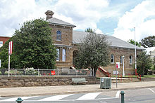 Cooma Post Office
Two newspapers operate in Cooma, The Cooma Monaro Express owned by Fairfax Media, and the independently owned The Monaro Post, which began in 2006, owned by Oliver Mohr.[6]
Radio stations
- 2XL 918 AM (commercial)
- Snow FM 97.7 FM (commercial)
- Triple J 100.1 FM
- ABC South-East 810 AM/1602 AM
- Radio National 95.3 FM/100.9 FM
- Classic FM 99.3
- Monaro FM 90.5 (community)
- Racing Radio 96.9 FM
Note: transmitters for 2XL and Snow FM, as well as some ABC services, are in place throughout the Snowy Mountains.
Transport
Cooma is serviced by Cooma - Snowy Mountains Airport which is 15 kilometres from the CBD. Cooma has a bus service connecting various areas of town three times a day run by Cooma Coaches. Cooma is serviced by CountryLink buses which make daily journeys to both Canberra and the Bega Valley. Cooma has a taxi service run by Cooma Radio Taxis. Passenger trains operated to Cooma (the Cooma Mail) until 1986.[7]
The Cooma Monaro Railway is a heritage railway using historic NSW Railmotors built in the 1920s. The railway operates a weekend and Public Holiday service to Bunyan and Chakola[8] on a portion of track used by the Bombala railway line.
People associated with Cooma
People born in Cooma include:
- John (Bērziņš), bishop of the Russian Orthodox Church Outside Russia, bishop of Caracas
- Carmen Duncan, actress
- Paula Duncan, actress
- Torah Bright, Olympic Snowboarder
- Jamie Burns, N.S.W Cricketer, 1927
- A. D. Hope, poet and essayist
- Flt Lt Pat Hughes DFC, RAAF pilot. One of The Few, Hughes was the highest scoring Australian in the Battle of Britain[9]
- John Tierney, politician
- John Tranter, poet
- Steve Liebmann, journalist
- Michael Gordon, rugby league player
- Brett White, rugby league player
- Sam Willams, rugby league player
- Charlotte Wood, author
Mars
The name Cooma is used as a name for a crater on the planet Mars, without specifically commemorating the town[10].
See also
- Cooma Correctional Centre
- Snowy Mountains Scheme
- Railway line through Cooma
- "Climate for Cooma". Bureau of Meteorology. Australian Government. http://www.bom.gov.au/climate/averages/tables/cw_070278.shtml. Retrieved 2009-02-24.
References and notes
- ^ a b "Cooma population statistics". ABS. http://www.censusdata.abs.gov.au/ABSNavigation/prenav/ProductSelect?newproducttype=QuickStats&btnSelectProduct=View+QuickStats+%3E&collection=Census&period=2006&areacode=UCL121200&geography=&method=&productlabel=&producttype=&topic=&navmapdisplayed=true&javascript=true&breadcrumb=LP&topholder=0&leftholder=0¤taction=201&action=401&textversion=false. Retrieved 2009-02-24.
- ^ "Cooma". Geographical Names Board of New South Wales. http://www.gnb.nsw.gov.au/name_search/extract?id=JPIOZxUlGH. Retrieved 12 July 2009.
- ^ "Bombala Line". www.nswrail.net. http://www.nswrail.net/lines/show.php?name=NSW:bombala. Retrieved 2007-01-21.
- ^ "Cooma Railway Station". www.nswrail.net. http://www.nswrail.net/locations/show.php?name=NSW:Cooma&line=NSW:bombala:0. Retrieved 2007-01-21.
- ^ a b "Climate statistics for Cooma Visitors Centre". Bureau of Meteorology. http://www.bom.gov.au/climate/averages/tables/cw_070278_All.shtml. Retrieved 3 September 2011.
- ^ The Monaro Post
- ^ Banger C. The Railway Refreshment Rooms of New South Wales 1855-1995. ARHS Bulletin, Vol 54, no.790. August 2003.
- ^ http://www.cmrailway.org.au/
- ^ Distinguished Flying Cross : Flight Lieutenant P C Hughes, 234 Squadron RAF AWM Collection Record: REL/17986.001
- ^ Categories for Naming Features on Planets and Satellites, Gazetteer of Planetary Nomenclature, USGS Astrogeology Science Center, NASA
Coordinates: 36°14′06″S 149°07′33″E / 36.235°S 149.12583°E
Categories:- Towns in New South Wales
- Australian Aboriginal placenames
- Snowy Mountains Scheme


Wikimedia Foundation. 2010.