- Pennsylvania Route 434
-
PA Route 434
Route information Maintained by PennDOT Length: 12.46 mi[1] (20.05 km) Existed: 1967 – present Major junctions West end:  PA 739 in Blooming Grove Township
 US 6 in Greeley
East end: 
 NY 55 / CR 11 in Shohola Township
Location Counties: Pike Highway system Roads in Pennsylvania
Interstate • US • State • Legislative←  PA 433
PA 435  →
→←  PA 36
PA 36
PA 38  →
→←  PA 136
PA 138  →
→Pennsylvania Route 434 (designated by the Pennsylvania Department of Transportation as SR 0434) is a 12.46-mile (20.05 km) long state highway located in northeast Pennsylvania. The western terminus of the route is at Pennsylvania Route 739 in the Blooming Grove Township community of Lords Valley. The eastern terminus of the route is at the New York-Pennsylvania border in Shohola Township, where PA 434 crosses the Delaware River and enters New York, becoming New York State Route 55 at an intersection with New York State Route 97 in the town of Highland. State Route 434 is formerly part of Pennsylvania Route 37 and Pennsylvania Route 137.
Contents
Route description
 Sign for Route 434 northbound in Greeley
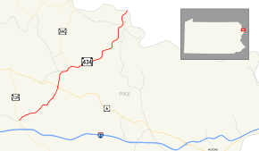
Route 434 begins at an intersection with Route 739 and Pike County Quadrant Route 4004 in Lords Valley, a community in Blooming Grove Township. Route 434 heads to the northeast, passing businesses and homes before leaving the community. The highway then gets into a more scenic rural region, with trees surrounding the highway. Route 434, which makes several curves for the next few miles, passes to the south of a lake. The highway continues on for several miles in this way.[1] A short time later, the highway passes a couple homes and crosses Shohola Creek. Just north of the creek, the area becomes somewhat urbanized with homes beginning to surround the road again. However, this does not last long, with forests returning once more. Just north of the community, Route 434 intersects and becomes concurrent with U.S. Route 6. The concurrency, which is just south of Greeley, does not stick long, with Route 434 heading to the northeast once again.[1]
After the concurrency with U.S. Route 6, the surroundings around the highway become a mix of homes and forests. This lasts for much of the distance on Route 434 until Greeley, where it becomes urbanized again. In downtown Greeley, Route 434 splits at an intersection where Pennsylvania Route 590 begins. The highway makes a curve, turning to the southeast for a distance north of Greeley. Soon afterwards, Route 434 parallels Shohola Creek, heading northeastward.[1] Route 434 begins to become urbanized for a third time, passing some large buildings along with homes and forests. The creek continues to parallel, with the highway turning in several different directions. The forests begin to recede as Route 434 enters Shohola Township. There it begins to pass more of fields and homes. Twin Lakes Road, a quadrant route, terminates at Route 434 before crossing the Delaware River and becoming New York State Route 55 and Sullivan County Route 11 at the border.[1]
History
In 1928, what is now Pennsylvania Route 590 between Lackawaxen and present-day PA 434 in Greeley was designated Pennsylvania Route 37.[2] From Greeley, PA 37 continued south along the PA 434 alignment to its southern terminus at U.S. Route 6.[2] In 1946, PA 37 was removed from the PA 590 alignment.[3][4]
While PA 37 occupied the 1.5-mile (2.4 km) segment of modern PA 434 from US 6 to Greeley, a spur of PA 37, Pennsylvania Route 137, occupied the remainder of PA 434 from Greeley to the state line from 1928 to 1946. In 1946, however, PA 37 was realigned to follow the entire alignment of PA 434 from US 6 to New York, decommissioning PA 137 in the process.[3] PA 37 remained in existence until 1967 when PA 37 was replaced by PA 434.[5] In 2004, State Route 434 was extended from its southern terminus down to an intersection with State Route 739 in Lords Valley.[6][7]
Major intersections
The entire route is in Pike County.
Location Mile[1][8][9] Destinations Notes Lords Valley 0.00 PA 739Eastern terminus of Quadrant Route 4004. Greeley 3.86 US 6Begin/end concurrency 3.96 US 6Begin/end concurrency Shohola Township 12.46 NY 55 / CR 11Western terminus of NY 55 and Sullivan CR 11; Barryville-Shohola Bridge 1.000 mi = 1.609 km; 1.000 km = 0.621 mi References
- ^ a b c d e f Yahoo! Inc. Yahoo! Maps – Overview map of PA 434 (Map). Cartography by NAVTEQ. http://maps.yahoo.com/#mvt=h&lat=41.475732&lon=-74.91283&zoom=18&q1=41.367541%2C-75.062508&q2=41.475696%2C-74.912621. Retrieved 2008-06-03.
- ^ a b Pennsylvania Department of Highways (1928). Map Showing Pennsylvania State Highways (Map).
- ^ a b Pennsylvania Department of Highways (1946). Pennsylvania Official Road Map (Map).
- ^ Pennsylvania Department of Highways (1947). Pennsylvania Official Road Map (Map).
- ^ Pennsylvania Department of Highways (1967). Pennsylvania (Map).
- ^ Pennsylvania Department of Transportation (2003). Pennsylvania (Map).
- ^ Pennsylvania Department of Transportation (2004). Pennsylvania (Map).
- ^ Yahoo! Inc. Yahoo! Maps – Overview map of PA 434 from 739 to 6 (Map). Cartography by NAVTEQ. http://maps.yahoo.com/#mvt=m&lat=41.402599&lon=-75.006758&zoom=16&q1=41.367551%2C-75.06242&q2=41.400137%2C-75.008561. Retrieved 2008-10-01.
- ^ Yahoo! Inc. Yahoo! Maps – Overview map of PA 434 from 739 to end of 6 concurrency (Map). Cartography by NAVTEQ. http://maps.yahoo.com/#mvt=m&lat=41.402599&lon=-75.014955&zoom=16&q1=41.367551%2C-75.06242&q2=41.400137%2C-75.008561&q3=41.40062%2C-75.009762. Retrieved 2008-10-01.
External links
Categories:- State highways in Pennsylvania
- Transportation in Pike County, Pennsylvania


Wikimedia Foundation. 2010.