- Cattaraugus County, New York
-
Coordinates: 42°14′N 78°41′W / 42.24°N 78.68°W
Cattaraugus County, New York 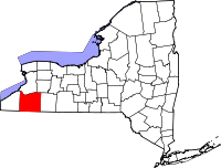
Location in the state of New York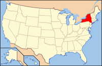
New York's location in the U.S.Founded 1808 Seat Little Valley Largest city Olean Area
- Total
- Land
- Water
1,310 sq mi (3,393 km²)
1,298 sq mi (3,362 km²)
12 sq mi (31 km²), 1.21%Population
- (2010)
- Density
80,317
62/sq mi (23.8/km²)Website www.co.cattaraugus.ny.us Cattaraugus County is a county located in the U.S. state of New York. As of the 2010 census, the population was 80,317. The county seat is Little Valley.
Contents
History
When counties were established in New York State in 1683, the present Cattaraugus County was part of Albany County. This was an enormous county, including the northern part of New York State as well as all of the present State of Vermont and, in theory, extending westward to the Pacific Ocean. This county was reduced in size on July 3, 1766 by the creation of Cumberland County, and further on March 16, 1770 by the creation of Gloucester County, both containing territory now in Vermont.
On March 12, 1772, what was left of Albany County was split into three parts, one remaining under the name Albany County. One of the other pieces, Tryon County, contained the western portion (and thus, since no western boundary was specified, theoretically still extended west to the Pacific). The eastern boundary of Tryon County was approximately five miles west of the present city of Schenectady, and the county included the western part of the Adirondack Mountains and the area west of the West Branch of the Delaware River. The area then designated as Tryon County now includes 37 counties of New York State. The county was named for William Tryon, colonial governor of New York.
In the years prior to 1776, most of the Loyalists in Tryon County fled to Canada. In 1784, following the peace treaty that ended the American Revolutionary War, the name of Tryon County was changed to Montgomery County in honor of the general, Richard Montgomery, who had captured several places in Canada and died attempting to capture the city of Quebec, replacing the name of the hated British governor.
Ontario County was split from Montgomery County in 1789. In turn, Genesee County was split from Ontario County in 1802. Shortly afterwards, Genesee County was made smaller in 1806, by the creation of Allegany County.
Cattaraugus County was formed in 1808, split off from Genesee County. However, at first there was no county government due to the sparse population. From 1812 to 1814, Cattaraugus County was incorporated in Allegany County; from 1814 to 1817, records of the county were divided between Belmont (Allegany County) and Buffalo (then in Niagara County). Finally, in 1817, a county government was established for Cattaraugus County.
The first settlement in the county was in Olean and the original county seat was Ellicottville. After 1860, the county seat was moved to Little Valley.
Geography
Cattaraugus County is in the southwestern part of the state, immediately north of the Pennsylvania border. The southern part of Cattaraugus County is the only area of western New York that was not covered by the last ice age glaciation and is noticeably more rugged than neighboring areas that had peaks rounded and valleys filled by the glacier. The entire area is actually a dissected plateau of Pennsylvanian and Mississippian age, but appears mountainous to the casual observer. The plateau is an extension of the Allegany Plateau from nearby Pennsylvania. Southern Cattaraugus County is part of the same oil field, and petroleum was formerly a resource of the area. It is now mostly played out, but natural gas continues to be extracted.
A continental divide between the Mississippi River and Great Lakes watersheds runs through Cattaraugus County
According to the U.S. Census Bureau, the county has a total area of 1,322 square miles (3,424.0 km2), of which 1,310 square miles (3,392.9 km2) is land and 12 square miles (31.1 km2) (0.94%) is water.
The northern border of the county is formed by Cattaraugus Creek.
Adjacent counties
- Erie County, New York - north
- Wyoming County, New York - northeast
- Allegany County, New York - east
- McKean County, Pennsylvania - southeast
- Warren County, Pennsylvania - southwest
- Chautauqua County, New York - west
Transportation
Major highways

 Interstate 86/New York State Route 17 (Southern Tier Expressway)
 U.S. Route 62
 U.S. Route 219
 New York State Route 16
 New York State Route 98
 New York State Route 240
 New York State Route 242
 New York State Route 353
 New York State Route 417
Airports
Great Valley Airport is located in Cattaraugus County, one nautical mile (1.85 km) southeast of the central business district of Great Valley.[1][2]
There's also an airport outside of Olean.
Demographics
Historical populations Census Pop. %± 1820 4,090 — 1830 16,724 308.9% 1840 28,872 72.6% 1850 38,950 34.9% 1860 43,886 12.7% 1870 43,909 0.1% 1880 55,806 27.1% 1890 60,866 9.1% 1900 65,643 7.8% 1910 65,919 0.4% 1920 71,323 8.2% 1930 72,398 1.5% 1940 72,652 0.4% 1950 77,901 7.2% 1960 80,187 2.9% 1970 81,666 1.8% 1980 85,697 4.9% 1990 84,234 −1.7% 2000 83,955 −0.3% 2010 80,317 −4.3% Source[3][4] As of the census[5] of 2000, there were 83,955 people, 32,023 households, and 21,647 families residing in the county. The population density was 64 people per square mile (25/km²). There were 39,839 housing units at an average density of 30 per square mile (12/km²). The racial makeup of the county was 94.63% White, 1.06% Black or African American, 2.60% Native American, 0.46% Asian, 0.02% Pacific Islander, 0.23% from other races, and 1.01% from two or more races. 0.94% of the population were Hispanic or Latino of any race. 26.8% were of German, 13.2% Irish, 11.3% English, 9.1% Polish, 8.2% Italian and 7.4% American ancestry according to Census 2000. 95.2% spoke English and 1.4% Spanish as their first language.
There were 32,023 households out of which 32.10% had children under the age of 18 living with them, 52.30% were married couples living together, 10.80% had a female householder with no husband present, and 32.40% were non-families. 26.80% of all households were made up of individuals and 11.60% had someone living alone who was 65 years of age or older. The average household size was 2.52 and the average family size was 3.05.
In the county the population was spread out with 26.20% under the age of 18, 9.30% from 18 to 24, 26.50% from 25 to 44, 23.50% from 45 to 64, and 14.60% who were 65 years of age or older. The median age was 37 years. For every 100 females there were 95.90 males. For every 100 females age 18 and over, there were 92.50 males.
The median income for a household in the county was $33,404, and the median income for a family was $39,318. Males had a median income of $30,901 versus $22,122 for females. The per capita income for the county was $15,959. About 10.00% of families and 13.70% of the population were below the poverty line, including 18.60% of those under age 18 and 9.90% of those age 65 or over.
Government and politics
Cattaraugus County is run by a unicameral legislature with an appointed county "administrator," who serves many executive duties of a county executive but has no legislative veto power and is not elected. The legislators themselves are independently elected (while some also serve as mayors of the villages they represent, their status as mayors does not affect in any way their seats on the legislature and thus it is not a Board of Supervisors). The votes of each legislator are counted in proportion to the number of people that said legislator represents (for example, if a legislator from Olean has 10,000 people in his/her district, and the legislator serving Lyndon only has 5,000, the Lyndon legislator's vote has only half the worth of the Olean legislator's). There are currently 21 members of the legislature with 13 Republicans and 8 Democrats; the county is in the process of reducing that number to 17. Each legislator serves a four year term, with a limit of three terms.
The legislature is a majority Republican, with Michael O'Brien serving as chairman.
- 01 - Paula J. Stockman (R)
- 02 - E. James Ellis (R) and Patrick J. Murphy (R)
- 03 - Norman Marsh (R) and Robert E. Neal (R)
- 04 - William Sprague (D)
- 05 - Donna Vickman (R), Charles Hebdon (D) and Jerry Burrell (R)
- 06 - Michael O'Brien (R) and Joseph McLarney (R)
- 07 - James Boser (D) and Vergilio Giardini (D)
- 08 - Mark J. Ward (D)
- 09 - Kenneth McClune (D) and Carmen Vecchiarella (R)
- 10 - Leo Nenno (D), John Padlo (D), James J. Snyder (R), William Aiello (R) and Steven Teachman (R)
Cattaraugus County is entirely within the boundaries of the 149th New York State Assembly District (served currently by Joseph Giglio), the 57th New York State Senate District (served currently by Catharine Young), and the U.S. House of Representatives 29th district (served currently by Tom Reed). In the last of these, Cattaraugus County's votes proved pivotal in the 2008 elections: incumbent Republican Randy Kuhl, who had strongly carried the county in 2004 and 2006, lost Cattaraugus County to Democrat Eric Massa in the 2008 elections.
The county is generally considered a "red county," with Republicans usually outvoting Democrats in most statewide and national offices (for instance, in 2004 George W. Bush defeated John Kerry in Cattaraugus County by a 60-40 margin) though Bill Clinton won the Cattaraugus County very narrowly in 1996. However, in 2006, the county narrowly chose Eliot Spitzer over John Faso by a margin of about 1% in the governor's race, and Hillary Clinton surprisingly defeated John Spencer in the county by a 10 percentage point margin. (That being said, in all other positions up for office that year, Republicans—including all congressional and state legislature representatives—still won.) In 2008 it continued its tradition as a red county. John McCain defeated Barack Obama by a 55-44% margin. In 2010, Republican Carl Paladino carried Cattaraugus County over Democrat (and eventual winner) Andrew Cuomo 65% to 31%, but Senator Kirsten Gillibrand and Senator Chuck Schumer, both incumbent Democrats, carried the county by 51% to 46% and 54% to 43% margins respectively.
An emerging trend among Cattaraugus County's villages has been consolidation with their surrounding towns. Limestone voters approved dissolution into the town of Carrolton in September 2009; that took effect at the beginning of 2011. On March 18, 2010, three other villages (East Randolph, Randolph and Perrysburg) followed suit and approved dissolution into their surrounding towns (Randolph Township for the first two, and Perrysburg Township for the third); these three villages will dissolve at the beginning of 2012.
Additional facts about Cattaraugus County
There are two separate geological formations, both called "Rock City," in the county that have the appearance of a town laid out with streets. One is in Olean and the other is in Little Valley.
Olean is the largest city in the county and is the major center for business. Ski country runs through Cattaraugus County; two ski resorts, popular with Canadians, lie in the town of Ellicottville; in addition, several snowmobile trails cross the county, including the Pat McGee Trail, a flagship for the county's trail system, and the North Country Trail.
Cattaraugus County's current promotional nickname is the Enchanted Mountains, despite the fact that the county is mostly hills and that only two comparatively small "mountains" (Mount Seneca and Mount Tuscarora, both in Allegany State Park) exist in the county. During the 1980s, the county used the slogan Naturally Yours to Enjoy.
Cattaraugus County is considered part of Appalachia, as well as Western New York, upstate New York, the Southern Tier, the Twin Tiers and the Buffalo-Niagara-Cattaraugus Combined Statistical Area. As a result of this geographic crossroads, the people of Cattaraugus County speak a variety of accents, ranging from mild variants of Appalachian English to Inland Northern American English, with a handful of people speaking in the more loud and nasal Buffalo English.
The sales tax in Cattaraugus County is 8% (4% from New York State, 4% from the county).
Famous Cattaraugus County natives and residents
See also: :Category:People from Cattaraugus County, New York- Bill Bergey, professional football player
- Governor Blacksnake, Seneca war chief and possibly the world's oldest man
- Ray Caldwell, MLB pitcher
- Phil "The Showkiller" Ceppaglia, producer for The Tony Kornheiser Show, attended St. Bonaventure
- Anna Botsford Comstock, 1854–1930, artist, Cornell professor, leader of nature study movement
- Chuck Crist of Salamanca, professional football player
- Brian Dunkleman of Ellicottville, co-host of the first season of American Idol
- Ray Evans (1915–2007) of Salamanca, member of famous songwriting duo alongside Jay Livingston
- Ira Joe Fisher of Salamanca and Little Valley, weatherman at CBS
- James F. Hastings of Olean, retired former U.S. Congressman (served from 1969 to 1976)
- Marvin "Marv" Hubbard of Randolph, professional football player
- Maureen Keenan LeBoeuf of Olean, first female Department Head at the West Point Military Academy
- Don McLean sang/wrote the original version of "American Pie" while in Olean
- Riki Lindhome of Portville, actress and member of the satirical musical group "Garfunkel and Oates"
- Ted Marchibroda, NFL Head Coach of Baltimore Colts/Ravens, attended St. Bonaventure University
- Paul Owens (1924–2003) of Salamanca, professional baseball player, manager, and executive
- Stephen Porcello of Portville, celebrated song writer and musician
- Kimberly Pressler of Franklinville, Miss USA 1999
- Timothy L. Kellner of Ischua, U.S. Sniper legend
- Margaret Shulock of Franklinville, cartoonist, part of the ensemble behind the Six Chix comic strip
- Peter Tomarken (1942–2006) of Olean, host of Press Your Luck
- Martha Van Rensselaer (1864–1932), educator and founder of Cornell University College of Human Ecology
Dean T. Atkins of East Randolph, nationally known expert in heating and ventillation technology.
In addition, a few minor celebrities have summer homes in the county, including newsman Irv Weinstein and former professional football kicker Steve Christie.
Newspapers
- Salamanca Press (weekly, serving Salamanca and a few other small towns)
- Olean Times Herald (daily, serving all of the western Twin Tiers)
- Olean Source (free weekly)
- Special E-Fects (free weekly, based in Ellicottville and serving mostly that town and village)
- The Villager (free weekly, based in Ellicottville)
- Gowanda Pennysaver News (free weekly)
- Randolph Register (monthly)
Radio stations
- WPIG (95.7, Olean)
- WHDL (1450, Olean)
- WOLN (91.3, Olean, operated out of Buffalo)
- WQRS (98.3, Salamanca)
- WGGO (1590, Salamanca)
- WGWE (105.9, Little Valley, operated from the Allegany Reservation)
- WOEN (1360, Olean)
- WMXO (101.5, Olean)
- WTWT (90.5, transmitter in Allegany, licensed to Bradford, PA, operated out of Russell, PA)
- WWG32 (162.425, Little Valley, operated out of Buffalo)
Television stations
- WONS-LP (Ch. 25, Olean)
Educational institutions
A branch of Jamestown Community College, in Olean provides higher education for residents. Olean Business Institute provides specialized education and is also in Olean. St. Bonaventure University is also in this county.
Cities, towns, villages, and other locations

- Allegany (village)
- Allegany (town)
- Ashford (town)
- Carrollton (town)
- Cattaraugus (village)
- Coldspring (town)
- Conewango (town)
- Dayton (town)
- Delevan (village)
- East Otto (town)
- East Randolph (village, to be dissolved 2012-01-01)
- Ellicottville (village)
- Ellicottville (town)
- Farmersville (town)
- Franklinville (village)
- Franklinville (town)
- Freedom (town)
- Gowanda (village)
- Great Valley (town)
- Hinsdale (town)
- Humphrey (town)
- Ischua (town)
- Leon (town)
- Lime Lake-Machias (census-designated place)
- Limestone (census-designated place)
- Little Valley (village)
- Little Valley (town)
- Lyndon (town)
- Machias (town)
- Mansfield (town)
- Napoli (town)
- New Albion (town)
- Olean (city)
- Olean (town)
- Otto (town)
- Perrysburg (village, to be dissolved 2012-01-01)
- Perrysburg (town)
- Persia (town)
- Portville (village)
- Portville (town)
- Randolph (town)
- Randolph (village, to be dissolved 2012-01-01)
- Red House (town)
- Salamanca (city)
- Salamanca (town)
- Steamburg (hamlet)
- South Dayton (village)
- South Valley (town)
- St. Bonaventure (census-designated place)
- West Valley (hamlet)
- Weston Mills (census-designated place)
- Yorkshire (town)
- Designation in parentheses indicates official level of government.
Indian reservations
- Allegany Reservation, New York
- Cattaraugus Reservation, Cattaraugus County, New York
- Oil Springs Reservation, Cattaraugus County
See also
- List of counties in New York
- National Register of Historic Places listings in Cattaraugus County, New York
References
- ^ FAA Airport Master Record for N56 (Form 5010 PDF). Federal Aviation Administration. Effective 8 April 2010.
- ^ "Great Valley Airport (N56)" (PDF). New York State Department of Transportation. https://www.nysdot.gov/divisions/operating/opdm/aviation/repository/air_dir/n56.pdf.
- ^ New York State Department of Economic Development
- ^ http://factfinder2.census.gov
- ^ "American FactFinder". United States Census Bureau. http://factfinder.census.gov. Retrieved 2008-01-31.
External links
- Cattaraugus County CattCo.org
- Cattaraugus County at the Open Directory Project
- Cattaraugus County webpage
- Western Southern Tier information
- Cattaraugus historical links/information
- Summary early history of Cattaraugus County and its communities
- Cattaraugus County Industrial Development Agency
- Enchanted Mountains of Cattaraugus County (Tourism Site)
- Little Valley Area Chamber of Commerce

Erie County Wyoming County Chautauqua County 
Allegany County  Cattaraugus County, New York

Warren County, Pennsylvania McKean County, Pennsylvania Municipalities and communities of Cattaraugus County, New York Cities 
Towns Allegany | Ashford | Carrollton | Coldspring | Conewango | Dayton | East Otto | Ellicottville | Farmersville | Franklinville | Freedom | Great Valley | Hinsdale | Humphrey | Ischua | Leon | Little Valley | Lyndon | Machias | Mansfield | Napoli | New Albion | Olean | Otto | Perrysburg | Persia | Portville | Randolph | Red House | Salamanca | South Valley | Yorkshire
Villages Allegany | Cattaraugus | Delevan | East Randolph | Ellicottville | Franklinville | Gowanda‡ | Little Valley | Perrysburg | Portville | Randolph | South Dayton
CDPs Other
hamletsIndian
reservationsFootnotes ‡This populated place also has portions in an adjacent county or counties
Categories:- New York counties
- Cattaraugus County, New York
- 1808 establishments in the United States
- Populated places established in 1808


Wikimedia Foundation. 2010.