- Clackmannanshire
-
Clackmannanshire
Clackmannanshire
Siorrachd Chlach Mhannainn
Logo Coat of arms Location 
Geography Area Ranked 30th - Total 159 km2 (61 sq mi) Admin HQ Alloa (current)
Clackmannan (historic)ISO 3166-2 GB-CLK ONS code 00QF Demographics Population Ranked 29th - Total (2005) 50,600 - Density 319 / km² Politics Clackmannanshire Council
http://www.clacks.gov.uk/Control Labour (minority control) MPs - Gordon Banks, Labour
MSPs - Keith Brown, Scottish National Party
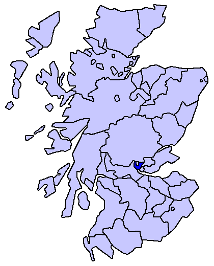
Clackmannanshire, often abbreviated to Clacks (Scots: Clackmannanshire and from the Scottish Gaelic: Siorrachd Chlach Mhannainn meaning 'Stone of Manau') is a local government council area in Scotland, and a lieutenancy area, bordering Perth and Kinross, Stirling and Fife.
As Scotland's smallest historic county, it is often nicknamed 'The Wee County'.
Between 1889 and 1975, the County of Clackmannan was a local government county, bordering on Perthshire, Stirlingshire and Fife.
The council area was recreated in 1996, under the Local Government etc (Scotland) Act 1994, with the boundaries of the former Clackmannan district of the Central region. Prior to the Central District being created in 1975 the area had historically been called Clackmannanshire and there was strong pressure to resurrect this title rather than hold to the rather bland title of "Central Region". Central Region had been created in 1975, under the Local Government (Scotland) Act 1973, to include the county of Clackmannan plus the Muckhart and Glendevon areas, formerly in the county of Perth. Technically these two areas had been transferred to Clackmannanshire in 1971 under a reorganisation of boundaries.
According to the legislation of 1996, the council area was to have the name, Clackmannan, of the former district, but this was changed to Clackmannanshire, by the council using its own powers.
In terms of population, it is the smallest council area in mainland Scotland, with a population of 48,630 (in 2005), around half of whom live in the main town, Alloa, which is the administrative centre, having outgrown the town of Clackmannan in 1822.
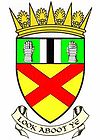
The motto of Clackmannanshire is "Look Aboot Ye" (Circumspice in Latin). In 2007 a re-branding exercise led to the area adopting the slogan "More Than You Imagine". [1] [2]
Contents
Council political composition
Party Councillors Labour 8 Scottish National Party 7 Conservative 1 Liberal Democrat 1 Independent 1 Geography
The Ochil Hills lie in the Strathdevon or northern part of the area. Strathdevon mostly comprises a lowland plain a few hundred meters either side of the River Devon, and this goes on to contribute to the formation the valley of the River Forth and joins the Forth near Cambus. There is also the Black Devon river that flows past the town of Clackmannan to join the River Forth near Alloa. This confluence once had a small pier for portage to Dunmore pier and anchorage of smaller sailing ships, where others of more tonnage could be accepted at Dunmore pier on the opposite banks of the forth.
Economy
The main industries are agriculture, brewing, and formerly coal mining. In 2006, permission was given for a waterfront development of the Docks area of Alloa, which has been in decline since the 1960s.
Alloa railway station reopened in May 2008. A new railway line connecting Kincardine and Stirling, reconnecting Alloa to the national rail network for the first time since 1968 was opened to the public. Passenger services only operate towards Stirling, the line to Kincardine is for freight trains only. An opening ceremony was held on Thursday 15 May, with the first fully functioning passenger service commencing in the new summer timetable on 19 May 2008.[3][4] The service provides an hourly connection between Alloa, Stirling and Glasgow Queen Street.
History
Clackmannan — County (until circa 1890) — 
Country Scotland County town Clackmannan Area - Total 123 km2 (47.5 sq mi) Ranked 34th Chapman code CLK Clackmannan, the old county town, is named after the ancient stone associated with the pre-Christian deity Manau or Mannan.[5] The stone now rests on a larger stone beside the Tollbooth and Mercat Cross at the top of Main street, Clackmannan.[6]
Legend has it that Robert the Bruce mislaid his glove while in the area and, on asking where it was, was told "Look aboot ye". The county's coat of arms shows a pair of gloves.
Clackmannanshire became known for the weaving mills powered by the Hillfoots burns. Other industries included brewing, glass manufacture, mining and ship building.
Now capitalising on its central position and transport links, Clackmannanshire attracts service industries and tourism.
Towns and villages
- Alloa - administrative centre
- Alva
- Cambus
- Clackmannan
- Coalsnaughton
- Devonside
- Dollar
- Fishcross
- Forestmill
- Glenochil
- Inglewood
- Kennet
- Menstrie
- Muckhart
- Sauchie
- Solsgirth
- Tillicoultry
- Tullibody
Places of interest
- Alloa Tower
- Ben Cleuch
- Castle Campbell
- Gartmorn Dam
- Menstrie Castle
References
- ^ http://commons.wikimedia.org/wiki/File:Clackmannanshire_More_than_you_imagine_Sign_at_Menstrie.jpg Image of road sign with slogan "Clackmannanshire More than you imagine"
- ^ http://commons.wikimedia.org/wiki/File:Welcome_to_Clackmannanshire.jpg Image of road sign at border of Clackmannanshire with slogan "More than you imagine"
- ^ Railway information | Clackmannanshire Council
- ^ Stirling Alloa Kincardine Railway celebrates first anniversary | ClacksWeb
- ^ http://commons.wikimedia.org/wiki/File:Clackmannan_sign_about_stone,_cross_and_tollbooth.jpg
- ^ http://commons.wikimedia.org/wiki/File:Clackmannanstane.jpg Image of the Stone of Mannan
External links
- Clacksweb - Clackmannanshire Council Online
- Clackmannanshire at the Open Directory Project
- ClacksNet - Clackmannanshire's Community Network
- Census 2001 Information (PDF)
- National Library of Scotland - Clackmannanshire Map ca. 1681
- Look Aboot Ye - Clackmannanshire Community News, Information and Forums
- ASH Consulting Group 1998. Clackmannanshire landscape character assessment. Scottish Natural Heritage Review No 96.
Council areas of Scotland Aberdeen · Aberdeenshire · Angus · Argyll and Bute · Clackmannanshire · Dumfries and Galloway · Dundee · East Ayrshire · East Dunbartonshire · East Lothian · East Renfrewshire · Edinburgh · Falkirk · Fife · Glasgow · Highland · Inverclyde · Midlothian · Moray · Na h-Eileanan Siar (Western Isles) · North Ayrshire · North Lanarkshire · Orkney · Perth and Kinross · Renfrewshire · Scottish Borders · Shetland · South Ayrshire · South Lanarkshire · Stirling · West Dunbartonshire · West Lothian
Former local government counties of Scotland Subdivisions created by the Local Government (Scotland) Act 1889 and abolished by the Local Government (Scotland) Act 1973 Aberdeenshire · Angus · Argyll · Ayrshire · Banffshire · Berwickshire · Bute · Caithness · Clackmannanshire · Dumfriesshire · Dunbartonshire · East Lothian · Fife · Inverness-shire · Kincardineshire · Kinross-shire · Kirkcudbrightshire · Lanarkshire · Midlothian · Moray · Nairnshire · Orkney · Peeblesshire · Perthshire · Renfrewshire · Ross and Cromarty · Roxburghshire · Selkirkshire · Shetland · Stirlingshire · Sutherland · West Lothian · WigtownshireSubdivisions abolished by the Local Government (Scotland) Act 1889 Categories:- Clackmannanshire
- Districts of Scotland
- Counties of Scotland
- Lieutenancy areas of Scotland
- Council areas of Scotland


Wikimedia Foundation. 2010.