- Allegheny River
-
For other uses of Allegheny, see Allegheny (disambiguation).
Allegheny River 
The Allegheny River, looking upstream at Freeport, PennsylvaniaOrigin Allegany Township, Potter County, near Coudersport, Pennsylvania
41°52′22″N 77°52′30″W / 41.8728449°N 77.874998°WMouth Ohio River at Pittsburgh, Pennsylvania
40°26′36″N 80°00′54″W / 40.4434025°N 80.0150536°WBasin countries United States Length 325 miles (523 km) Source elevation ~2,490 feet (759 m) Avg. discharge 19,750 cu ft/s (559 m3/s) at the village of Natrona, PA (river mile 24.3) [1] Basin area 11,580 sq mi (30,000 km2) The Allegheny River (
 /ælɨˈɡeɪni/) is a principal tributary of the Ohio River; it is located in the Eastern United States. The Allegheny River joins with the Monongahela River to form the Ohio River at the "Point" of Point State Park in Downtown Pittsburgh, Pennsylvania. The Allegheny River is, by volume, the main headstream of the Ohio River.
Contents
Geography
 Further information: Geography of Pennsylvania
The river is approximately 325 miles (523 km) long, running through the U.S. states of New York and Pennsylvania.[2] It drains a rural dissected plateau of 11,580 square miles (30,000 km2) in the northern Allegheny Plateau, providing the northeastern most drainage in the watershed of the Mississippi River. Its tributaries reach to within 8 miles (13 km) of Lake Erie in southwestern New York.
The Allegheny Valley has been one of the most productive areas of fossil fuel extraction in U.S. history, with its extensive deposits of coal, petroleum, and natural gas.
Etymology
 The Allegheny River is named as Ohio on a sketch of George Washington.
The word Allegheny comes from the Lenape (Delaware) Indians. Although the meaning has sometimes been given as "fine river" or "beautiful river," the etymology is not definitively known. There is a Lenape legend of a tribe called "Allegewi" who used to live along the river.
The following account of the origin of the name Allegheny was given in 1780 by Moravian missionary David Zeisberger: "All this land and region, stretching as far as the creeks and waters that flow into the Alleghene the Delawares called Alligewinenk, which means 'a land into which they came from distant parts'. The river itself, however, is called Alligewi Sipo. The whites have made Alleghene out of this, the Six Nations calling the river the Ohio."[3]
Other Indians, such as the Iroquois, considered the Allegheny and Ohio rivers as the same, as is suggested by a New York State road sign on Interstate 86 that refers to the Allegheny River also as O Hi Yo.[4] The Geographic Names Information System lists O-hee-yo and O-hi-o as variant names.[2] In New York, areas around the river are often named with the alternate spelling Allegany in reference to the river; for example, the Village of Allegany and Allegany State Park.
Course
 Much of the Allegheny River's course is through hilly woodlands.
The Allegheny River rises in north central Pennsylvania, on Cobb Hill in central Potter County, approximately 10 miles (16 km) south of the New York border. It flows west past Coudersport then turns north into western New York, looping westward across southern Cattaraugus County for approximately 30 miles (48 km), past Portville, Olean, St. Bonaventure University and Salamanca and flowing through Seneca Indian Nation lands close to the northern boundary of Allegany State Park before re-entering northwestern Pennsylvania approximately 20 miles (32 km) southeast of Jamestown, New York.
It flows in a broad zigzag course generally southward across Western Pennsylvania; first flowing southwest past Warren, Tidioute, Tionesta, Oil City, and Franklin, forming much of the northwestern boundary of Allegheny National Forest. South of Franklin it turns southeast across Clarion County in a meandering course, then turns again southwest across Armstrong County, flowing past Kittanning, Ford City, Clinton, and Freeport.
 The Highland Park Bridge crosses the Allegheny River at Aspinwall, Pennsylvania, just above Allegheny River Lock and Dam Two.
The river enters both Allegheny and Westmoreland counties, the Pittsburgh suburbs, and the City of Pittsburgh from the northeast. It passes Sligo, Karns, and Natrona in Harrison Township; Metcalf, Braeburn, Lower Burrell, and New Kensington; Brackenridge, Tarentum, Creighton, Clyde, Springdale, Harmarville, Blawnox, Fox Chapel, Sharpsburg, Etna, Millvale, Lawrenceville, Highland Park, the North Side, Downtown Pittsburgh, and Point State Park. The Allegheny joins with the Monongahela River at the "Point" in Downtown Pittsburgh, Pennsylvania to form the Ohio River.
Water from the Allegheny River eventually flows into the Gulf of Mexico via the Ohio and Mississippi rivers.
Tributaries
Main article: List of tributaries of the Allegheny RiverIn its upper reaches, the Allegheny River is joined from the south by Potato Creek 1.7 miles (2.7 km) downstream of Coryville, Pennsylvania and from the north by Olean Creek at Olean, New York. Tunungwant "Tuna" Creek joins the river from the south in Carrollton, New York (flowing north from Bradford, Pennsylvania); the Great Valley Creek and Little Valley Creek join the river from the north at Salamanca, New York before becoming the Allegheny Reservoir.
After re-entering Pennsylvania, the river is joined from the east by Kinzua Creek 10 miles (16 km) upstream of Warren; from the north by Conewango Creek at Warren; from the west by Brokenstraw Creek; from the east by East Hickory Creek at East Hickory; from the east by Tionesta Creek at Tionesta; from the north by Oil Creek at Oil City; from the west by French Creek at Franklin; from the east by the Clarion River, a principal tributary, at Parker; from the east by Crooked Creek southeast of Kittanning; and from the east by the Kiskiminetas River, another principal tributary, at Schenley. Buffalo Creek enters at Freeport, Chartiers Run enters at Lower Burrell, Bull Creek enters at Tarentum, Pucketa Creek enters near New Kensington, Riddle Run enters at Springdale, and Girtys Run enters at Millvale. Many additional streams enter or join with the Allegheny River along its course.
River modifications
 The eastern part of Allegheny Islands State Park and the C. W. Bill Young Lock and Dam (No. 3) on the Allegheny River
The Allegheny River has eight locks and dams (numbered two through nine), which form corresponding pools.
Flood control
The river is also impounded by the Kinzua Dam in northwestern Pennsylvania, resulting in the Allegheny Reservoir. The Seneca Pumped Storage Generating Station is associated with Kinzua Dam.
Crossings
Main article: List of crossings of the Allegheny RiverNumerous bridges and tunnels span the river throughout its course. The Allegheny River Tunnel for Pittsburgh Light Rail is under construction as of 2010.
History
In the 16th century, control of the river valley passed back-and-forth between Algonquian-speaking Shawnee and the Iroquois. By the time of the arrival of the French in the early 18th century, the Shawnee were once again in control and formed an alliance with the French against the incursion of British settlement across the Allegheny Mountains. The conflict over the expansion of British settlement into the Allegheny Valley and the surrounding Ohio Country was a primary cause of the French and Indian War in the 1750s. During the war, the village of Kittanning – the principal Shawnee settlement on the river – was completely destroyed by British reprisal raids from Central Pennsylvania.
Nevertheless, the British, after gaining control of the area in the 1763 Treaty of Paris, kept the area closed to white settlement, in part to repair and maintain relations with the Native Americans. The pressure to open the river valley and the surrounding area to settlement is considered by historians to be one of the root causes of the American Revolutionary War in the following decade.
During the 19th century, the river became a principal means of navigation in the upper Ohio valley, especially for the transport of coal. Although the building of the railroads lessened the importance of the river somewhat, the lower river (navigable as far as East Brady, Pennsylvania through locks) has continued to serve as route of commercial transportation until the present day. In 1859, the first U.S. petroleum was drilled north of the river at Titusville.
One of the underlying premises of the Genesee Valley Canal was its connection to the river, opening a trade route from Rochester, New York to the west. The advent of the railroads destroyed any interest that Pennsylvania might have had in participating by improving navigation on the river.
 Seneca Chief Cornplanter
In 1965, the completion of the federally-sponsored Kinzua Dam for flood-control in northwestern Pennsylvania east of Warren created the long Allegheny Reservoir, part of which is included in the Allegheny National Recreation Area. The dam flooded parts of lands deeded "forever" to the Seneca Nation of Indians by the 1794 Treaty of Canandaigua, and to lands given to Cornplanter and his descendants. The event was described in the Johnny Cash song "As Long as the Grass Shall Grow" from the 1964 album Bitter Tears: Ballads of the American Indian, which focused on the history of and problems facing Native Americans in the United States.
The construction of the dam and the filling of the Allegheny Reservoir also necessitated the elimination of the small village of Corydon, which was located at the confluence of Willow Creek with the Allegheny River; and the small village of Kinzua, which was located at the confluence of Kinzua Creek with the Allegheny River. All residents of both villages were forced to move.
 The Kinzua Dam and Allegheny Reservoir
Many prominent individuals opposed the construction of the dam at that time because of the damage it would do to Seneca lands, including Pennsylvania Congressman John P. Saylor of Johnstown, and Howard Zahniser, executive director of The Wilderness Society and native of Tionesta—a small settlement located along the Allegheny River several miles downstream from Warren. During the campaign for the 1960 United States presidential election, John F. Kennedy assured the Seneca Nation that he would oppose the dam if elected. However, he failed to follow through on his pledge upon becoming president.
In 1992, 86.6 miles (139.4 km) of the Allegheny River was designated Wild and Scenic. This designation comprises three segments of the river located in Warren, Forest, and Venango counties.[5]
In 2008, Katie Spotz became the first person to swim the entire 325 miles (523 km) of the Allegheny River; she was accompanied by safety kayaker, James Hendershott.[6] The team began at the river's source in Raymond, Pennsylvania on July 22 and finished at the "Point" in Downtown Pittsburgh on August 21.[7]
Settlements along the river
- New York
- Allegany
- Carrollton
- Olean
- Portville
- Pennsylvania
 The Allegheny River at Foxburg, Pennsylvania
 The Allegheny (left) and Monongahela (right) join to form the Ohio River at Pittsburgh, Pennsylvania.
See also
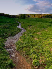 The headwaters of the Allegheny River are in this meadow in Potter County
- Allegheny Islands State Park
- Allegheny Riverfront Park
- List of rivers of New York
- List of rivers of Pennsylvania
- Pittsburgh Flood of 1936
- Pittsburgh Three Rivers Regatta
References
- ^ USGS Data Report 2009
- ^ a b "Allegheny River". Geographic Names Information System, U.S. Geological Survey. http://geonames.usgs.gov/pls/gnispublic/f?p=gnispq:3:::NO::P3_FID:1209386. Retrieved 2010-05-13.
- ^ Zeisberger, David (1999). David Zeisberger's History of the Northern American Indians in 18th Century Ohio, New York and Pennsylvania. Wennawoods Publishing. p. 33. ISBN 1-889037-17-6.
- ^ Stewart, George R. (1967). Names on the Land. Boston, Massachusetts: Houghton Mifflin Company. p. 8. ISBN 0-938530-02-X.
- ^ Allegheny Wild and Scenic River – Allegheny National Forest
- ^ Shuster, Patrick; Garrone, Francine (2008-08-18). "Ohio woman swimming length of Allegheny River". Pittsburgh Tribune-Review (Tribune-Review Publishing Company). http://www.pittsburghlive.com/x/pittsburghtrib/news/cityregion/s_583539.html. Retrieved 2009-05-10.
- ^ Nephin, Dan (2008-08-22). "Swimmer completes 325-mile swim of Allegheny". Pittsburgh Tribune-Review (Tribune-Review Publishing Company). http://www.pittsburghlive.com/x/pittsburghtrib/news/cityregion/s_584351.html. Retrieved 2009-05-10.
Further reading
- Schafer, Jim; Mike Sajna (1992). The Allegheny River: Watershed of the Nation. University Park, Pennsylvania, US: The Pennsylvania State University Press. ISBN 978-0-271-00836-3.
External links
Categories:- Allegheny River
- Wild and Scenic Rivers of the United States
- Geography of Pittsburgh, Pennsylvania
- Geography of Cattaraugus County, New York
- Rivers of Pennsylvania
- Geography of Allegheny County, Pennsylvania
- Geography of Westmoreland County, Pennsylvania
- Geography of Armstrong County, Pennsylvania
- Geography of Clarion County, Pennsylvania
- Geography of Venango County, Pennsylvania
- Geography of Butler County, Pennsylvania
- Geography of Forest County, Pennsylvania
- Geography of Warren County, Pennsylvania
- Geography of McKean County, Pennsylvania
- Geography of Potter County, Pennsylvania
- Tributaries of the Ohio River


Wikimedia Foundation. 2010.