- Briningham
-
Coordinates: 52°52′06″N 1°01′31″E / 52.86825°N 1.02538°E
Briningham 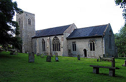
Saint Maurice, Briningham, Norfolk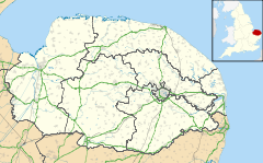
 Briningham
Briningham shown within NorfolkArea 4.96 km2 (1.92 sq mi) Population 122 (parish, 2001 census) - Density 25 /km2 (65 /sq mi) OS grid reference TG030340 - London 124 miles (200 km) Parish Bodham CP District North Norfolk Shire county Norfolk Region East Country England Sovereign state United Kingdom Post town MELTON CONSTABLE Postcode district NR24 Dialling code 01263 Police Norfolk Fire Norfolk Ambulance East of England EU Parliament East of England List of places: UK • England • Norfolk Briningham is a village and a civil parish in the English county of Norfolk.[1] The village is 9.9 miles east north east of the town of Fakenham, 13.3 miles west south west of Cromer, 22.3 miles north north west of the city of Norwich, and 124 miles north north east of London. The nearest railway station is at Sheringham for the Bittern Line which runs between Sheringham, Cromer and Norwich. There is an abandoned railway line which is considered as a footpath, it runs parallel with an old track "the lane" that leads up to "belle vue tower". The nearest airport is Norwich International Airport. The civil parish had in 2001 census a population of 122. For the purposes of local government, the parish falls within the district of North Norfolk.
Contents
History
Briningham has an entry in the Domesday Book of 1085.[2] In the great book Briningham is recorded by the names Bruningaham, and Biringaham. The main landholders were Count Alan and Bishop William. The main tenant is said to be Roger Longwood. The survey also mentions that there are five beehives, a church and a mill.
Buildings
The main and oldest buildings are "belle vue tower";originally thought to have been a mill but was actually watch tower,rose cottage, the mission hall; the old Methodist chapel and the mill lane houses.
Saint Maurice parish church
The parish church of Saint Maurice is unusual in that the church tower is on the south side.[3] On the east wall of the interior there are two large statues of Saint Maurice and the Blessed Virgin which are set into niches. In the south wall there is a 14th century window. Within the graveyard stands a ten-foot-high pyramidal memorial to members of the Brermer family, on top of which sits the head of a muzzled bear. It is a Grade I listed building [1].
Notable people
Notable residents include the late Peter Whitbread.
References
- ^ OS Explorer Map 24 - Norfolk Coast Central. ISBN 0-319-21726-4
- ^ The Domesday Book, Englands Heritage, Then and Now, Editor: Thomas Hinde,Norfolk page 187, Briningham, ISBN 1858334403
- ^ Norfolk 1: Norwich and North-East, By Nikolaus Pevsner and Bill Wilson, Briningham entry. ISBN 0-300-09607-0
Categories:- Villages in Norfolk
- Civil parishes in Norfolk
- Norfolk geography stubs


Wikimedia Foundation. 2010.