- Cerro de la Muerte
-
Cerro de la Muerte 
Cerro de la Muerte from the city of San IsidroElevation 3,451 m (11,322 ft) Location Costa Rica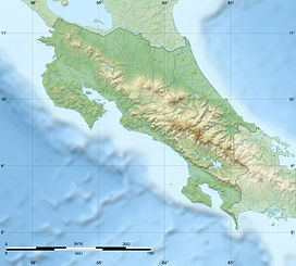
 Cerro de la Muerte
Range Cordillera de Talamanca Coordinates 9°34′N 83°45′W / 9.567°N 83.75°WCoordinates: 9°34′N 83°45′W / 9.567°N 83.75°W Climbing Easiest route road Cerro de la Muerte is the highest point in the Costa Rican section of the Inter-American Highway. Its name means "Mountain of Death", since in the past crossing the mountains from the Valle Central meant a three or four day journey, on foot or on horseback, and many ill-prepared travelers succumbed to the cold and rain. However, the peak is now easily accessible since the highway runs close by.
The drivable track from the highway leads to the summit, with its cluster of telecommunications aerials. At this altitude, overnight temperatures can dip below freezing, but the sun soon raises the temperatures in the morning, with a high risk of sunburn in the thin clear air.
This mountain is in Talamanca range, which extends from eastern Costa Rica into neighbouring western Panama. This range was a volcanic island in the geological past, it raised result of tectonic uplift and its separation from other mountain ranges means that it has developed many endemic species of animals and plants, often with affinities to Andean forms.
The higher areas are páramo habitat, with stunted shrubs, dwarf bamboo, and tree ferns, and smaller plants like blueberry, gooseberry and lady's slipper. Below this zone, the natural vegetation is oak forest with bamboo understory, an excellent place to see the charismatic Resplendent Quetzal.[1]
Nearly fifty percent of the bird species recorded from Cerro de la Muerte are endemic to the Talamanca range. These include Fiery-throated Hummingbird, Timberline Wren, Sooty Robin, Black-billed Nightingale-Thrush, Peg-billed Finch and Volcano Junco.[1]
-

Paramo at the summit
-

Oak forest
-
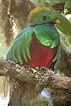
Resplendent Quetzal
References
- ^ a b Stiles and Skutch, A guide to the birds of Costa Rica, ISBN 0-8014-9600-4
External links
Categories:- Mountains of Costa Rica
-


Wikimedia Foundation. 2010.