- Salem, Oregon
-
Salem — City — The Oregon State Capitol.
Nickname(s): The Cherry City Location in Marion and Polk Counties, state of Oregon. Location in Oregon
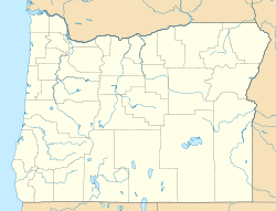
 Salem
SalemCoordinates: 44°55′51″N 123°1′44″W / 44.93083°N 123.02889°WCoordinates: 44°55′51″N 123°1′44″W / 44.93083°N 123.02889°W Country United States State Oregon Counties Marion, Polk Founded 1842 Government – Type City Council – City Manager – Mayor Anna M. Peterson Area – Total 46.4 sq mi (120.1 km2) – Land 44.8 sq mi (118.4 km2) – Water 0.6 sq mi (1.6 km2) Elevation 154 ft (46.7 m) Population (2010[1]) – Total 154,637 – Density 3,228.3/sq mi (1,246.5/km2) Time zone PST (UTC−8) – Summer (DST) PDT (UTC−7) Zip codes 97301, 97302, 97303, 97304, 97308, 97309, 97310, 97311, 97312, 97313 & 97314 Area code(s) 503 and 971 FIPS code 41-64900[2] GNIS feature ID 1167861[3] Website www.cityofsalem.net Salem (
 /ˈseɪləm/) is the capital of the U.S. state of Oregon, and the county seat of Marion County. It is located in the center of the Willamette Valley alongside the Willamette River, which runs north through the city. The river forms the boundary between Marion and Polk counties, and the city neighborhood of West Salem is in Polk County. Salem was founded in 1842, became the capital of the Oregon Territory in 1851, and was incorporated in 1857.
Salem had a population of 154,637 at the 2010 census, making it the third largest city in the state after Portland and Eugene. Salem is less than an hour driving distance away from Portland. Salem is the principal city of the Salem Metropolitan Statistical Area, a metropolitan area that covers Marion and Polk counties[4] and had a combined population of 347,214 at the 2000 census.[2] A 2009 estimate placed the metropolitan population at 396,103, the state's second largest.[5]
The city is home to Willamette University and Corban University, as well as the main city in the Salem-Keizer School District and is home to the main campus of Chemeketa Community College. Other schools include the Chemawa Indian School, and the Oregon School for the Deaf. The state of Oregon is the largest employer in the city, with Salem Hospital as the largest private employer. Transportation includes public transit from Salem-Keizer Transit, Amtrak service, and non-commercial air travel at McNary Field. Major roads include Interstate 5, Oregon Route 99E, and Oregon Route 22 which connects West Salem across the Willamette River via the Marion Street and Center Street bridges.
Contents
History
Origin of name
 Map of Salem in 1876
The Native Americans who originally inhabited Salem, the Kalapuyans called the area Chemeketa, which means "meeting or resting place" in the Central Kalapuya language (Santiam). The original Kalapuya pronunciation of the word is Chim-i-ki-ti.[6] When the Methodist Mission moved to the Chemeketa plain, the new establishment was called Chemeketa, but was more widely known as the Mill because of its situation on Mill Creek.[7] When the Oregon Institute was established, the community was known as the Institute.[7]
When the Institute was dissolved, the trustees decided to lay out a townsite on the Institute lands.[7] It is uncertain who chose the name "Salem" for the new town, but it is believed to be one of two people: trustee David Leslie from Salem, Massachusetts, or William H. Willson who in 1850–1851 filed the plats for the main part of the city.[7] There were many names suggested and even after the change to Salem, some people, such as Asahel Bush (editor of the Oregon Statesman), believed the name should be changed back to Chemeketa.[8]
The name Salem is derived from the semitic words (Arabic salam [سَلاَمٌ] and Hebrew shalom [שָׁלוֹם]) for peace. The Vern Miller Civic Center which houses the city offices and library has a public space dedicated as the Peace Plaza in recognition of the names by which the city has been known.[8] Salem is also thought to be the original name of Jerusalem used in Genesis 14:18.[9][10]
Native Americans
It is estimated that the Willamette Valley area has been inhabited for over 10,000 years. The Kalapuya peoples would gather on the plateau east and south of the current downtown area in the winter and establish camps. They fished and harvested in the streams and fields of the area. One staple of life was the camas root and periodically the Kalapuya would set fires that would clear and fertilize the meadows where it grew.[11] In the early 1850s the Kalapuya, along with the other native peoples west of the Cascade Mountains, were removed by the US government through a combination of treaties and force. Most Kalapuya people were moved to the Grande Ronde Reservation somewhat to the west of Salem, with smaller numbers ending up at Siletz Reservation and other Oregon and Washington reservations.[12]
Europeans
The first people of European descent arrived in the area as early as 1812; they were animal trappers and food gatherers for the fur trading companies in Astoria, Oregon.
The first permanent American settlement in the area was the Jason Lee Methodist mission (1840) located in the area north of Salem known as Wheatland.[13] In 1842, the missionaries established the Oregon Institute (the forerunner of Willamette University) in the area that was to become the site of Salem. In 1844, the mission was dissolved and the town site established.
In 1851, Salem became the territorial capital after it was moved from Oregon City. The capital was moved briefly to Corvallis in 1855, but was moved back to Salem permanently that same year. Salem incorporated as a city in 1857 and with the coming of statehood in 1859 became the state capital.
Capitol buildings
 Capitol building after 1935 fire.
Oregon has had three capitol buildings in Salem. A two-story state house, which had been occupied for only two months, burned to the ground in December 1855. Oregon's second capitol building was completed in 1876 on the site of the original. The revival-style building was based in part on the U.S. Capitol building. The building received its distinctive copper dome in 1893. On April 25, 1935, this building was also destroyed by fire. The third and current Oregon State Capitol was completed on the same site in 1938. It is recognizable by its distinctive pioneer statue atop the capitol dome that is plated with gold-leaf and officially named the Oregon Pioneer.
State fair and cherry festival
 Oregon State Fair 1867
Agriculture has always been important to Salem and the city has historically recognized and celebrated it in a number of ways. In 1861, Salem was chosen as the permanent site of the Oregon State Fair by the Oregon State Agricultural Association.[14] Salem is nicknamed the "Cherry City", because of the past importance of the local cherry-growing industry.[15] The first cherry festival in Salem was held in 1903 and was an annual event, with parades and the election of a cherry queen, until sometime after World War I. The event was briefly revived as the Salem Cherryland Festival for several years in the late 1940s.[16]
Geography and climate
Salem is located in the north-central Willamette Valley, in Marion and Polk counties. The 45th Parallel (halfway between the North Pole and the Equator) passes through Salem's city limits.
According to the United States Census Bureau, the city has a total area of 46.4 square miles (120 km2), of which, 45.7 square miles (118 km2) of it is land and 0.6 square miles (1.6 km2) of it (1.35%) is water.
Although the Willamette River flows through Salem, the North Santiam River watershed is Salem's primary drinking water source. Other important streams that pass through Salem are Mill Creek, the Mill Race, Pringle Creek, and Shelton Ditch.[17] Smaller streams in eastern part of the city include Clark Creek, Jory Creek, Battle Creek, Croisan Creek, and Claggett Creek, while Glen Creek and Brush Creek flow through West Salem.[17]
Elevation within the city limits ranges about 120 to 800 feet (37 to 240 m). Salem contains the volcanic Salem Hills in the south and is sandwiched by the 1,000 ft (300 m) Eola Hills directly to the West and the 600 ft (180 m) Waldo Hills to the east. Northern and eastern Salem are less hilly. South and West Salem contain some canyons and are the hilliest areas. The coast range and the Cascades including Mount Hood, Mount Jefferson, and on the clearest of days, Mount St. Helens can be viewed throughout the city.
Like most of the Willamette Valley area, Salem has a Marine West Coast climate (Köppen Cfb) with some distinct characteristics of the Mediterranean climate. Rain is heaviest in late fall and throughout winter, but precipitation is spread from October until May, with a dry season from June through September. Light snowfall does occur in winter, but major snow events are rare. Mostly cloudy skies, and low cloud ceilings are commonplace during the rainy season.
Salem's mean annual temperature is 52.6 °F (11.4 °C);[18] its annual precipitation is 40 inches (1,020 mm), with an average 6 inches (15 cm) of snow included. However, the median snowfall over the 1971–2000 period was 0.[18] Salem is about 47 miles (76 km) south of Portland, but actually has a lower average temperature than Portland (53.5 °F (11.9 °C)).[19]
Climate data for Salem, Oregon (1971–2000) Month Jan Feb Mar Apr May Jun Jul Aug Sep Oct Nov Dec Year Average high °F (°C) 47.0
(8.3)51.2
(10.7)56.3
(13.5)61.1
(16.2)67.5
(19.7)74.0
(23.3)81.5
(27.5)81.9
(27.7)76.6
(24.8)64.5
(18.1)52.4
(11.3)46.4
(8.0)63.4 Average low °F (°C) 33.5
(0.8)34.7
(1.5)36.6
(2.6)38.8
(3.8)43.6
(6.4)48.4
(9.1)52.0
(11.1)52.1
(11.2)47.7
(8.7)41.3
(5.2)37.9
(3.3)33.9
(1.1)41.7 Precipitation inches (mm) 5.84
(148.3)5.09
(129.3)4.17
(105.9)2.76
(70.1)2.13
(54.1)1.45
(36.8)0.57
(14.5)0.68
(17.3)1.43
(36.3)3.03
(77)6.39
(162.3)6.46
(164.1)40.00
(1,016)Snowfall inches (cm) 1.4
(3.6)2.1
(5.3)0.1
(0.3)0
(0)0
(0)0
(0)0
(0)0
(0)0
(0)0
(0)0.4
(1)2.0
(5.1)6.0
(15.2)Avg. precipitation days (≥ 0.01 in) 17.3 15.8 16.9 14.0 11.3 7.7 3.4 3.9 6.7 11.0 18.2 18.0 144.2 Avg. snowy days (≥ 0.1 in) 1.0 0.9 0.2 0 0 0 0 0 0 0 0.3 1.2 3.6 Source: NOAA[18] Demographics
Historical populations Census Pop. %± 1860 902 — 1870 2,139 137.1% 1880 2,538 18.7% 1890 3,422 34.8% 1900 4,258 24.4% 1910 14,094 231.0% 1920 17,679 25.4% 1930 26,266 48.6% 1940 30,908 17.7% 1950 43,140 39.6% 1960 49,142 13.9% 1970 68,296 39.0% 1980 89,233 30.7% 1990 107,786 20.8% 2000 136,924 27.0% 2010 154,637 12.9% Sources:[20][21][1] As of the census[2] of 2000, there were 136,924 people, 50,676 households, and 32,331 families residing in the city. The population density was 2,994.0 people per square mile (1,156.1/km²). There were 53,817 housing units at an average density of 1,176.8 per square mile (454.4/km²). The racial makeup of the city was 83.1% White, 1.3% African American, 1.5% Native American, 2.4% Asian, 0.5% Pacific Islander, 7.9% from other races, and 3.4% from two or more races. Hispanic or Latino of any race were 14.6% of the population.
There were 50,676 households out of which 32.4% had children under the age of 18 living with them, 47.7% were married couples living together, 11.6% had a female householder with no husband present, and 36.2% were non-families. 28.3% of all households were made up of individuals and 10.5% had someone living alone who was 65 years of age or older. The average household size was 2.53 and the average family size was 3.10.
In the city the population was spread out with 25.4% under the age of 18, 11.4% from 18 to 24, 30.1% from 25 to 44, 20.6% from 45 to 64, and 12.4% who were 65 years of age or older. The median age was 34 years. For every 100 females, there were 100.9 males. For every 100 females age 18 and over, there were 99.5 males.
The median income for a household in the city was $38,881, and the median income for a family was $46,409. Males had a median income of $34,746 versus $26,789 for females. The per capita income for the city was $19,141. About 10.5% of families and 15.0% of the population were below the poverty line, including 20.2% of those under age 18 and 7.1% of those age 65 or over.
Government
Salem is governed using the council–manager government model.[22] The city council consists of eight members who are elected from single member wards. The mayor is elected in a citywide vote.
Economy
 Capitol Center in downtown
State government is Salem's largest employer, but the city also serves as a hub for the area farming communities and is a major agricultural food processing center.[23] It lies along the I-5 corridor and is within an hour's drive of Oregon's largest city, Portland.
In a bid to diversify its economic base, Salem attracted a number of computer-related manufacturing plants in the 1990s. In November 2003, the Sumitomo Mitsubishi Silicon Group (SUMCO), one of these arrivals, announced it would be closing its two silicon wafer plants at the end of 2004, eliminating 620 jobs, and moving production to other plants.[24]
The top private employer in Salem is the Salem Hospital with over 2,700 employees. Others include the Confederated Tribes of the Grand Ronde's Spirit Mountain Casino west of Salem, the T-Mobile Calling Center, GE Security (Formerly Supra Products Inc.), Wells Fargo Customer Contact Center (Formerly Wachovia Securities), NORPAC Foods, Inc., Roth's Family Markets, Sanyo, and Willamette University.[25]
Salem is the headquarters of the Oregon Department of Corrections and home to four state correctional facilities, including the Oregon State Penitentiary, Oregon's only maximum security prison.
Numerous projects are underway to increase the supply of housing in the downtown core. These projects will provide upscale, low and high rise condominium and office space.
People and culture
Neighborhood associations
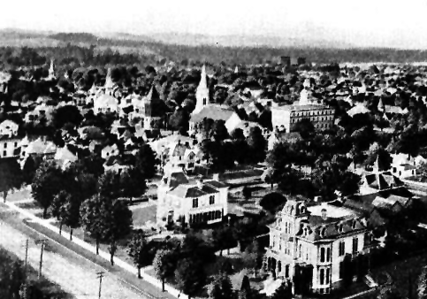
 Central area of Salem 1900
Salem has 19 recognized neighborhood associations, which are independent groups that receive administrative support from the city.[26][27]
- Central Area
- Croisan-Illahe
- East Lancaster
- Faye Wright
- Grant
- Highland
- Lansing
- Morningside
- Northeast
- Northeast Salem
- Northgate
- North Lancaster
- South Central
- Southeast Mill Creek
- South East Salem
- South Gateway
- The boundaries of the area represented by South Gateway Neighborhood Association (SGNA) begin at the intersection of Liberty Road SE and Kuebler Boulevard SE, then south along the center line of Liberty Road to the city limits, then east along the southern city limits to its intersection with the center line of Interstate 5, then north along the center line of I-5 to the intersection with Kuebler Boulevard, then west along the center line of Kuebler Boulevard to the starting point.[28][29][30]
- South Salem
- Sunnyslope
- West Salem
Cultural events and series
 Skateboarder in Marion Square Park
From May through October the Salem Saturday Market, located north of the Capitol, exhibits an emphasis on local products including crafts, baked goods, produce, meat, and other items.[31] In addition to the Saturday Market, there is a Wednesday Farmers' Market hosted downtown in Courthouse Square during the summer, as well a Holiday Gift Market in December. The 60+ year old, indoor Saturday Public Market is open all year round.[32]
The annual World Beat Festival, held in June, is sponsored by the nonprofit Salem Multicultural Institute.[33] The event lasts for two days and is held at the Riverfront Park. It features international crafts, music, dance, food, and folklore from every continent, and in recent years has held a Dragon Boat race similar to the ones held during the nearby Rose Festival in Portland.[34]
The Salem Art Association sponsors the annual Salem Art Fair and Festival, which takes place at Bush's Pasture Park during the summer.[35] Its displays, interactive exhibits, food, and performances attract thousands of visitors each year.[36]
The Bite of Salem, held in July at the Riverfront Park, is an event similar to others such as the Bite of Oregon in Portland. The event consists of a weekend of local restaurants in Salem offering samples of their menus to patrons in a festival atmosphere, with live entertainment and benefiting local charities. In the summer, Chef's Nite Out is a wine and food benefit held for Marion-Polk Food Share.[37] Oregon Wine & Food Festival takes place at that state's fairgrounds in January.
The largest event in Salem is the Oregon State Fair at the end of August through Labor Day. Located in the Oregon State Fairgrounds in North Salem, the fair offers exhibits, competitions and carnival rides. Other events such as concerts, horse shows and rodeos take place at the Oregon State Fair and Expo Center throughout the year.[38]
The Mid-Valley Video Festival offers local, national and international independent films in theaters throughout the city.[39]
The Salem Film Festival has included feature films that were Oregon premieres.[40]
The Salem Repertory Theatre presents shows at the Reed Opera House.[41] The Pentacle Theatre, which features plays and musicals, is located in West Salem.[42] The Elsinore Theatre is a historic landmark featuring recitals, concerts, films, and plays. It has the largest working pipe organ on the west coast, a remnant of its days as a showcase for silent films, in the early days of cinema. Grand Theater is undergoing renovation and has hosted the Salem Progressive Film Series and other shows.
Capitol Pride (Salem's Gay yearly Pride Event) is held in early August.[43]
Museums and other points of interest
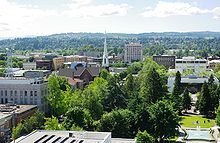 Downtown Salem looking west
In addition to the Oregon State Capitol and adjacent Willson Park, Salem's downtown contains the Mission Mill Museum, Hallie Ford Museum of Art, the Elsinore Theatre, Riverfront Park, the Willamette River, some of the oldest buildings in Oregon, as well as shopping and restaurants. The A.C. Gilbert's Discovery Village interactive children's museum and Prewitt-Allen Archaeological Museum are both also located in Salem.[44]
The two leading candidates for the tallest building in Salem are Salem First United Methodist Church and the Capitol Center.[45] A private survey commissioned by a local publication holds that the church is the tallest.[46] The tall white spire of the 1878 church rises at the intersection of Church and State Streets across from the Capitol grounds. The Capitol Center (originally the First National Bank Building, then the Livesley Building) was built in 1927 by former Salem mayor Thomas A. Livesley, a prominent Salem-area businessman and civic leader. At that time of its completion, it was the tallest commercial building in the state.[45]
In 1988, Livesley's family home was purchased through private donations and was donated to the state. It now serves as the official residence of the Governor and family. Now known as Mahonia Hall, it was placed on the National Register of Historic Places (NRHP) in 1990.
The Oregon Symphony, based in Portland, presents approximately ten classical and pops concerts each year in Salem. The Salem Chamber Orchestra includes professional area musicians as well as students.[47] The Salem Armory Auditorium has hosted touring bands including Korn and Phish.
Because Salem is the state capital, it has a multitude of government agencies, departments, and boards housed in buildings with architectural designs ranging from the early 20th century to examples of state-of-the-art civil building design.
The historic Reed Opera House in downtown Salem has a number of local shops and dining establishments, as well as an art gallery.
Salem has been awarded "Tree City USA" status by the National Arbor Day Foundation for 30 consecutive years for its dedication to urban forestry.[48] Salem was the first city in Oregon to receive the award.[49] In keeping with the city's "Cherry City" theme, flowering cherry trees have been planted along many Salem streets as well as on the Capitol Mall across from the Capitol.
The Salem Public Library's main branch is located just south of downtown. A branch library is located in West Salem (Polk County). The Library participates in the Chemeketa Cooperative Regional Library Service, so Salem Public Library cards are also valid in the member libraries in Yamhill, Polk, Marion, and parts of Linn County.
The film One Flew Over the Cuckoo's Nest was filmed at the Oregon State Hospital.
Salem and its environs have a multitude of wineries and vineyards that are open to the public, including Oregon's oldest winery, Honeywood Winery.[50][51]
Media
Salem currently has one daily newspaper, the Gannett-owned Statesman Journal, an independent monthly alternative newspaper Salem Weekly, and an on-line newspaper, Salem-News.com, that was established in 2004.[52] The Capital Press, a weekly agricultural newspaper, is published in the city and is distributed throughout the west coast. The monthly Salem Business Journal covers business and government.[53]
Northwest Television operates three television stations that have Salem transmitters: KWVT, KSLM, and KPWC, which serve an area from Longview, Washington to Eugene, Oregon. Two stations are licensed to Salem but operate out of Portland and Seattle respectively: KPXG and KRCW.
As of 2001,[citation needed] five radio stations broadcast from Salem, including four commercial AM stations and one non-commercial FM station. KBZY was a popular Top 40 station from its sign-on in 1957 through the 1960s and 1970s. Today KBZY has an oldies format, and continues to use live and local personalities. KBZY is affiliated with the ABC Radio Network. KYKN carries syndicated conservative talk hosts. KWOD is a Spanish language sports talk station. KPJC features Christian talk programming. KWBX is a non-commercial station licensed to Corban University with a Contemporary Christian format.
Salem is part of the Portland Arbitron survey area for radio stations, and most of the Portland stations can be received in Salem. Powerful AM news/talk stations include KEX, KXTG, and progressive talk KPOJ. Stations to the south in Corvallis and Albany are also easily heard in Salem.
NPR programming is carried by Oregon Public Broadcasting, which can be heard on KOPB-FM from Portland, and KOAC from Corvallis.
Sports
The Salem-Keizer Volcanoes, a minor league baseball team, play their home games in the city of Keizer, which adjoins Salem on the north. The Salem Stampede of the International Basketball League play their home games at the Salem Armory. Three teams within the Eugene-based NNFL are from Salem; the Copperheads, Chargers, and three-time league champion, Pioneers. The Willamette University Bearcats is also based in Salem, they are a Division III athletics program.
Parks and recreation
 Riverfront Park in downtown
City parks
Salem's Department of Community Services Parks Operations Division is responsible for a park system encompassing 1,874 acres (758 ha) with 29.53 miles (47.52 km) of trails, 46 parks, and another 55 open and undeveloped areas.[54]
Minto-Brown Island Park is the largest at 898.9 acres (363.8 ha).[55]
Bush's Pasture Park, a 90.5 acres (36.6 ha) urban park a few blocks south of downtown Salem, features natural groves of native Oregon White Oak trees, the historic Bush House, a rose garden, and adjacent Deepwood Estates.[56]
Other city parks include 101 acres (41 ha) Cascade Gateway Park and 23-acre (9.3 ha) Riverfront Park which is adjacent to downtown and the Willamette River and is home to the Salem Carousel. Marion Square Park is downtown next to Marion Street Bridge and has a skatepark and basketball court.[57] The skatepark also allows bicycles.[57] Marion Square Park was laid out by city founder William H. Willson, and is the next oldest municipal park in Salem after Willson Park at the Oregon State Capitol.[57]
Across the Willamette River in West Salem is the 114 acres (46 ha) Wallace Marine Park, which includes a boat ramp and floating boat dock allowing easy access to the river for water sports. The NRHP-listed Union Street Railroad Bridge, repurposed as a bicycle and pedestrian bridge, connects Wallace Marine Park and West Salem to Riverfront Park and downtown Salem.
Salem is also home to one of the smallest city parks in the world, Waldo Park, which consists of a single Sequoia tree.[58] Mill Ends Park park in Portland is the smallest in the state.
The capitol grounds, which is maintained by the Oregon Parks and Recreation Department, cover three city blocks and include Willson and Capitol parks.
Recreation
Other large parks located in the Salem area include 1,680 acres (680 ha) Willamette Mission State Park north of the city, and Silver Falls State Park east of Salem. Both of these parks have extensive hiking, biking, and horse trails.
Salem's central location provides access to a wide variety of recreational activities in a variety of climates and geographies year round. The Coast Range and the Pacific Ocean is to the west. The Santiam Canyon area, the Western Cascades and the High Cascades are to the east. Portland, Oregon and its environs are to the north, while Eugene, Oregon and its environs are to the south.
Salem also provides two great frisbe golf courses. A nine hole course located in the woods of Woodmansee Park (located behind Judson Middle School), and a more open style 18 hole course located throughout Cascade Gateway Park. They are both free and open to the public.
Education
 The Mark Hatfield Library and stream on the campus of Willamette University.
Elementary and secondary
Salem's public elementary and secondary schools are part of the Salem-Keizer School District which has approximately 39,000 students and is the second largest public school district in the state.[59] The city also has many private elementary and secondary schools such as Blanchet Catholic School and Salem Academy Christian. One school, Willamette Academy, is part of an outreach program run by Willamette University that is designed to expose under represented students to the rewards of an academic life at an early age (7th–12th grade).[60]
Salem is also home to several public boarding schools, the Chemawa Indian School a Native American high school and the Oregon School for the Deaf.
Colleges and universities
Post secondary schools include Chemeketa Community College, Corban University, Tokyo International University of America and Willamette University, the oldest university in the American west.[61] Portland State University and Eastern Oregon University provide classes and a handful of undergraduate degrees at Chemeketa Community College.
Infrastructure
Transportation
 Built in 1918, Salem's passenger train stop serves Amtrak.
Salem-Keizer Transit ("Cherriots"), an independent government agency, provides fixed-route bus service, rideshare matching, and paratransit/lift services for the disabled, within the urban growth boundary.
Chemeketa Area Regional Transportation System (CARTS) provides bus service that connects Salem to destinations as far north as Woodburn, as far west as Dallas, and to the east to Silverton and up the Santiam Canyon to Mill City.
Greyhound Lines provides north–south service and connecting carrier service to Bend, Oregon from its station downtown.
Amtrak, the national passenger rail system, leases the Salem Depot from the Oregon Department of Transportation. The Coast Starlight provides daily north–south service to cities between Los Angeles, California and Seattle, Washington. Amtrak Cascades trains, operating as far north as Vancouver, British Columbia and as far south as Eugene, Oregon, serve Salem several times daily in both directions.
Salem-Keizer Transit in cooperation with Wilsonville's SMART provide routes between downtown Salem and major employers in Wilsonville. From Wilsonville, passengers can be transported to downtown Portland via TriMet.
HUT Airport Shuttle provides transportation to Portland International Airport. HUT also serves Corvallis with a second stop at Oregon State University, Albany, and Woodburn. Mountain Express provides transportation between Salem and Bend.[62]
McNary Field (Salem Municipal Airport) is owned and operated by the City of Salem. It serves primarily general aviation and the Oregon National Guard – Army Aviation Support Facility (AASF). Delta Connection offered commercial air service with two daily flights to Salt Lake City, Utah from July, 2007. However, citing fuel costs versus occupancy of less than 85 per cent, the service was discontinued effective October 2008. The city plans to go forward with airport improvements that were announced when service was commenced, including a longer runway and an expanded terminal building.[63]
The city is served by the following highways:
- Interstate 5
- Oregon Route 99E
- Oregon Route 99E Business is a spur of the above, serving the downtown area
- Oregon Route 22
- Oregon Route 221
- Oregon Route 51
- Oregon Route 213
Healthcare
Salem Hospital Regional Health Services, one of the largest of Oregon's 57 acute care hospitals, a 454-bed acute care medical facility. It is a not for profit organization, and is also the city's largest private employer.[64]
Notable people
- Carmella Bing, pornographic actress
- Curt Coleman, Major League Baseball player
- John Fahey, musician, author and founder of Takoma records
- Alfred Carlton Gilbert, inventor, athlete, toy-maker, businessman, best known as the inventor of the Erector Set
- Jon Heder, actor, filmmaker and screenwriter
- Jed Lowrie, Major League Baseball shortstop
- Richard Laurence Marquette, serial killer
- James L. McCorkle, Jr., historian of the American South
- Douglas McKay, mayor of Salem, State Senator, Governor of Oregon, and United States Secretary of the Interior
- Leonard Stone, actor
Sister cities
Salem has four sister cities:[65]
 Salem, India
 Simferopol, Ukraine
 Kawagoe, Japan
 Gimhae, South Korea
Gallery
-

The Willamette Queen paddleboat on the Willamette River
-

First United Methodist Church in downtown
-

Marion County courthouse, located downtown
-

Wisteria covered alley in downtown Salem
-

A neighborhood in South Salem covered in snow
References
- ^ a b "2010 Census profiles: Oregon cities alphabetically R-S" (PDF). Portland State University Population Research Center. http://www.pdx.edu/sites/www.pdx.edu.prc/files/media_assets/2010_PL94_cities_R-S_updated.pdf. Retrieved 19 May 2011.
- ^ a b c "American FactFinder". United States Census Bureau. http://factfinder.census.gov. Retrieved 2008-01-31.
- ^ "US Board on Geographic Names". United States Geological Survey. 2007-10-25. http://geonames.usgs.gov. Retrieved 2008-01-31.
- ^ Metropolitan statistical areas and components, Office of Management and Budget, 2007-05-11. Accessed 2008-07-30.
- ^ "2009 Oregon Population Report" (PDF). Portland State University, Population Research Center. 2008-07-01. http://www.pdx.edu/sites/www.pdx.edu.prc/files/media_assets/PopRpt08c2.pdf. Retrieved 2010-02-01.
- ^ Johnson, Tony, Language Education Supervisor, CTGR Cultural Resources Division
- ^ a b c d McArthur, Lewis A.; Lewis L. McArthur (2003) [1928]. Oregon Geographic Names (Seventh ed.). Portland, Oregon: Oregon Historical Society Press. ISBN 0-87595-277-1.
- ^ a b Salem Online.net Salem name
- ^ http://www.biblegateway.com/passage/?search=Genesis%2014:18-20;&version=31;
- ^ MileChai.com definition
- ^ Salem History.net
- ^ "Siletz Indian Tribe History". Confederated Tribes of Siletz Indians. http://www.ctsi.nsn.us/chinook-indian-tribe-siletz-heritage/our-history/part-i/. Retrieved 2009-10-14.
- ^ Salem Online.net Brief history of Salem
- ^ Heine, Steven Robert The Oregon State Fair Images of America Arcadia Publishing 2007-08-20
- ^ Lucas,Bill. "The Cherry City". http://www.salemhistory.net/commerce/cherries.htm. Retrieved 2007-08-05.
- ^ Hermann, Shirley. "Salem's Cherry Festival". http://www.salemhistory.net/culture/cherry_festival.htm. Retrieved 2007-08-05.
- ^ a b "The Creeks of Salem". Salem Online History. http://www.salemhistory.net/natural_history/salems_creeks.htm. Retrieved 2008-01-31.
- ^ a b c "Climatography of the United States No. 20 (1971–2000)" (PDF). National Oceanic and Atmospheric Administration. August 2011. http://cdo.ncdc.noaa.gov/climatenormals/clim20/or/357500.pdf. Retrieved 2010-06-05.
- ^ "Climatography of the United States No. 20 (1971–2000)" (PDF). National Oceanic and Atmospheric Administration. 2004. http://cdo.ncdc.noaa.gov/climatenormals/clim20/or/356751.pdf. Retrieved 2010-05-31.
- ^ Moffatt, Riley. Population History of Western U.S. Cities & Towns, 1850–1990. Lanham: Scarecrow, 1996, 215.
- ^ "Subcounty population estimates: Oregon 2000–2007" (CSV). United States Census Bureau, Population Division. 2009-03-18. http://www.census.gov/popest/cities/files/SUB-EST2007-41.csv. Retrieved 2009-05-09.
- ^ City of Salem City Government homepage
- ^ "About Salem, Oregon". http://www.oregonlink.com/about_salem.html. Retrieved 2007-08-05.
- ^ "Statement from SUMCO on the closure". Statesman Journal. November 13, 2003. Archived from the original on 2007-03-14. http://web.archive.org/web/20070314071753/http://news.statesmanjournal.com/article.cfm?i=70734. Retrieved 2007-03-30.
- ^ "Salem's Largest Private Employers". http://www.salemchamber.org/employment/employers.html. Retrieved 2011-11-05.
- ^ Thompson, Dennis Associations unite neighbors, cities Statesman-Journal 2005-09-20 retrieved 2007-12-01
- ^ "Find Your Neighborhood". City of Salem. Archived from the original on 2007-03-03. http://web.archive.org/web/20070303152918/http://www.cityofsalem.net/export/departments/neighbor/map.htm. Retrieved 2007-08-05.
- ^ South Gateway Neighborhood Association Website
- ^ City of Salem – South Gateway Neighborhood map
- ^ City of Salem – South Gateway Neighborhood profile
- ^ Salem Saturday Market
- ^ Saturday Public Market
- ^ World Beat Festival
- ^ Perez, Elida Pacific Islands shine at World Beat, Statesman-Journal 2008-06-26 retrieved 2008-07-18
- ^ Salem Art Fair & Festival
- ^ Art fair is a party for Salem and its friends Statesman-Journal 2008-07-17 retrieved 2008-07-17
- ^ Chef's Nite Out
- ^ Oregon State Fair
- ^ Mid-Valley Video Festival
- ^ Salem Film Festival
- ^ Salem Repertory Theatre
- ^ Pentacle Theatre
- ^ http://www.capitolpride.org/
- ^ Tamaribuchi, Tara (September 1, 1999). "Museum is well-kept secret". Statesman Journal: p. 4C.
- ^ a b Kim, Eunice (November 15, 2007). "Landmark building's 80th birthday is reason to party". Statesman Journal. http://pqasb.pqarchiver.com/statesmanjournal/access/1720366691.html?FMT=ABS&FMTS=ABS:FT&type=current&date=Nov+15%2C+2007&author=EUNICE+KIM&pub=Statesman+Journal&edition=&startpage=C.1&desc=Landmark+building%27s+80th+birthday+is+reason+to+party. Retrieved 2008-03-08.
- ^ "The Answer: Salem Oregon's Tallest Building". Salemoregon.com. http://www.salemoregon.com/tallestbuilding/facts/buildingscompared.html. Retrieved 2008-03-08.
- ^ http://www.salemchamberorchestra.org/
- ^ "Tree Cities in Oregon". The National Arbor Day Foundation. http://www.arborday.org/programs/treecities.cfm?chosenstate=Oregon. Retrieved 2007-08-05.
- ^ "Salem, Oregon-Tree City USA". City of Salem. 1977-03-25. http://www.oregonlink.com/treecity.html. Retrieved 2007-08-05.
- ^ Oregon wine.org
- ^ Honeywood Winery
- ^ Salem-News.Com News from Salem Oregon and the surrounding region
- ^ http://www.salembusinessjournal.com Salem Business Journal
- ^ "Introduction to Salem's Park Division". City of Salem. Archived from the original on 2008-05-07. http://web.archive.org/web/20080507133129/http://www.cityofsalem.net/export/departments/parks/parks_introduction.htm. Retrieved 2007-12-11.
- ^ "Minto Brown Island Park". City of Salem. http://www.cityofsalem.net/Residents/Parks/ParkTour/Pages/Minto-Brown%20Island%20Park.aspx. Retrieved 2007-08-05.
- ^ "Bushs Pasture Park". City of Salem. Archived from the original on 2007-08-19. http://web.archive.org/web/20070819234807/http://www.cityofsalem.net/export/departments/parks/bush_park.htm. Retrieved 2007-08-05.
- ^ a b c "Marion Square Park". City of Salem. http://www.cityofsalem.net/Residents/Parks/ParkTour/Pages/Marion%20Square%20Park.aspx. Retrieved 2009-11-16.
- ^ "Waldo Park". City of Salem. Archived from the original on 2007-09-28. http://web.archive.org/web/20070928010540/http://www.cityofsalem.net/departments/parks/waldo_park.htm. Retrieved 2007-08-05.
- ^ Salem-Keizer Public Schools
- ^ Affirmative Action and Democratic Vistas: After the Supreme Court Michigan Cases
- ^ Gatke, Robert Moulton. 1943. Chronicles of Willamette, the pioneer university of the West. Portland, Or: Binfords & Mort.
- ^ Mountain Express
- ^ "Delta to ground flights out of Salem airport". Statesman Journal. July 12, 2008. http://www.statesmanjournal.com/apps/pbcs.dll/article?AID=/20080712/NEWS/807120335/1001/stayton. Retrieved 2008-07-15.[dead link]
- ^ http://www.salemhospital.org/about/stats.htm Salem Hospital
- ^ "City of Salem, OR Official Website". http://www.cityofsalem.net. Retrieved 2008-01-28.
Further reading
- MacGibbons, Elma. "Leaves of Knowledge". Shaw & Borden Co 1904. http://www.secstate.wa.gov/history/publications%5Fdetail.aspx?p=63. Reminiscences of MacGibbons travels in the United States starting in 1898, which were mainly in Oregon and Washington. Includes chapter "Salem, the capital of Oregon.
External links
- City of Salem
- Salem Online History
- Official Salem, Oregon tourism site
- The Salem Chamber of Commerce
- Oregon Blue Book entry for Salem
Categories:- Salem, Oregon
- Salem, Oregon metropolitan area
- Willamette Valley
- Cities in Oregon
- County seats in Oregon
- Populated places in Marion County, Oregon
- Populated places in Polk County, Oregon
- Populated places established in 1842


Wikimedia Foundation. 2010.