- Octoraro Creek
-
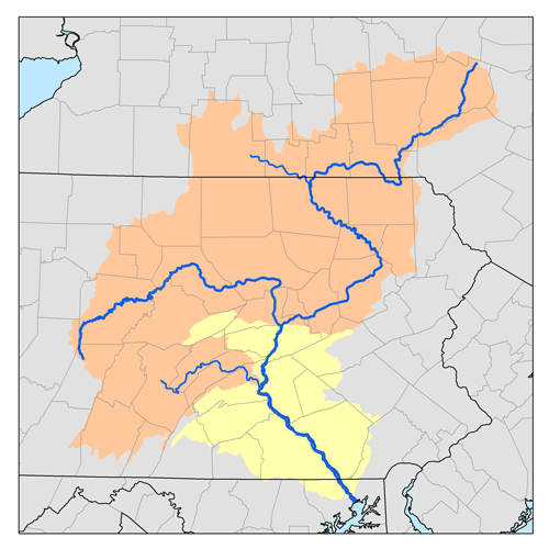
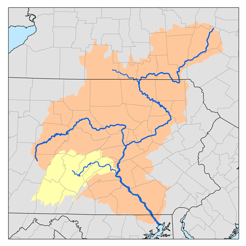
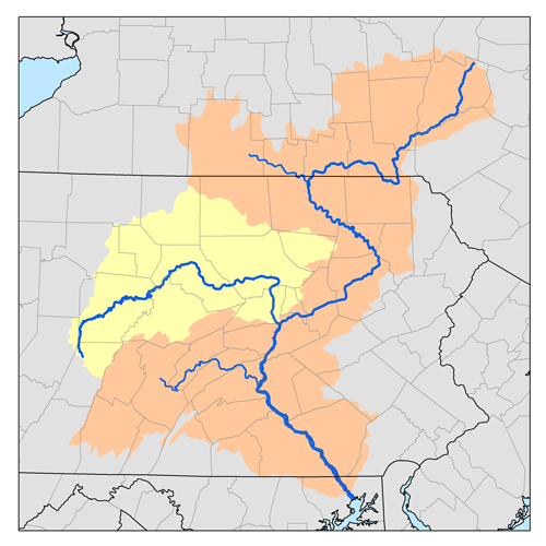
Octoraro Creek is a 22.1-mile-long (35.6 km)[1] tributary of the Susquehanna River, joining it 9 miles (14 km) above the Susquehanna's mouth at Chesapeake Bay. The Octoraro rises as an East and West Branch in Pennsylvania. The East Branch and Octoraro Creek form the southern half of the border between Lancaster and Chester counties until the creek crosses the Mason-Dixon line. It winds through northwestern Cecil County, Maryland before joining the Susquehanna.
Each of the branches is less than 20 miles (32 km) long. The entire creek drains 208 square miles (540 km2) of watershed.
Octoraro Creek was designated a Pennsylvania Scenic River by Legislative Act 1983-43, managed by the Octoraro Creek Watershed Association.
Contents
East Branch Octoraro Creek
The East Branch Octoraro Creek, 18.1 miles (29.1 km) long,[1] starts at Christiana, Pennsylvania, created by the confluence of Williams Run and Pine Creek, which carries the Lancaster - Chester County border for about a mile. The East Branch continues the border with Lancaster County to the west and Chester County on the east bank. The branch enters a steep wooded valley and passes under the Mercer's Mill Covered Bridge at Bailey Crossroads Road. The branch continues through the valley which widens out near Steelville. The branch loops through another steep valley north of Homeville, which widens out before the creek passes under PA Route 896 at Andrews Bridge. Muddy Run joins the East Branch from the east out of its own set of steep valleys. The East Branch widens out into the eastern part of Lake Octoraro about 3 miles (5 km) northwest of Oxford, Pennsylvania. Along the east branch of the lake is the Girl Scouts' Camp Tweedale.
West Branch Octoraro Creek
The West Branch Octoraro Creek runs 15.3 miles (24.6 km)[1] entirely in Lancaster County. The branch, which starts about a mile south of Green Tree, is created by the confluence of Meetinghouse Creek, Mine Run, and a small unnamed creek which starts near the village of Ninepoints. The branch flows under the Jackson's Sawmill Covered Bridge, northwest of Bartville, then flows for a few miles through a narrow valley, southwest of Collins. The valley widens as the branch passes under Puseyville Road. The branch passes under Noble Road at Kings Bridge and under the White Rock Forge Covered Bridge at White Rock. The branch then widens out into the western part of Lake Octoraro about two miles east of Oak Shade.
 Pine Grove Covered Bridge with the dam of the Octoraro Lake Reservoir in the background
Main branch Octoraro Creek
The dam that forms Octoraro Lake is on the main branch, just below the East and West Branch confluence, in Pine Grove. Below the dam is a filtration plant belonging to the Chester Water Authority. The main branch passes under Pine Grove Covered Bridge (Forge Road) before continuing generally southwestward. The creek passes under PA Route 272 at Kirks Bridge, less than three miles west of Nottingham. As the creek nears the Pennsylvania - Maryland border it goes through a series of alternating loops. The final horseshoe-like loop, where the creek first crosses the border, gives the name to the Boy Scouts of America's Horseshoe Scout Reservation and the Chester County Council's Order of the Arrow Lodge. The west-bound portion of that loop passes over Grays Hollow Ford, now replaced by an Army Corps of Engineers bridge. At this point the contrast of the BSA wilderness camp on the left bank with the active gravel mine on the right is apparent. The horseshoe loops back to the east, then briefly north up into Pennsylvania, all within the Reservation, before it swings back south into Maryland for good. The Scout Reservation contains the original Mason-Dixon Line mile-19 stone monument, along with the remains of a former grist mill along the old camp road.
Octoraro Creek in Maryland
In Maryland, Octoraro Creek winds generally southwest through a steep valley. The creek loops under the high tension lines from the Conowingo Hydroelectric Plant on their way toward Philadelphia and passes by the site of a removed dam. The creek crosses under U.S. Route 1 on that road's way from Philadelphia to the Conowingo Dam bridge and Baltimore. The creek then passes the washed-out Porters Bridge at Richardsmere and passes one final time under the high tension lines. At Rowlandsville, the creek passes under Doctor Jack Road and two abandoned railroad bridges on a defunct spur. The Octoraro passes under the active Norfolk Southern Railway bridge and MD Route 222 (formerly U.S. Route 222) before it reaches the Susquehanna River, below the Conowingo Dam. When the hydroelectric plant is not generating, along with a low tide (the Susquehanna experiences tides below the dam), the creek turns parallel to the river for a few hundred yards before joining. The six foot rise in water when the hydroelectric plant is operating inundates this parallel stretch and can cause the Octoraro to reverse flow as far as the 222 bridge.
See also
- List of Maryland rivers
- List of rivers of Pennsylvania
References
- ^ a b c U.S. Geological Survey. National Hydrography Dataset high-resolution flowline data. The National Map, accessed August 8, 2011
- USGS topographic maps and aerial photos were used extensively to prepare this article.
- "Octoraro Creek, PA". http://reference.allrefer.com/gazetteer/O/O00567-octoraro-creek.html. Retrieved 2007-09-29.
- "Octoraro Creek Covered Bridge Tour". http://www.co.lancaster.pa.us/lanco/cwp/view.asp?a=15&q=257085. Retrieved 2007-09-29.
External links
- U.S. Geological Survey: PA stream gaging stations
- PA Scenic Rivers map of Octoraro Creek
- Octoraro Creek Watershed Ecological Study
- Chester Water Authority article on the Octoraro Plant
Protected Areas of Pennsylvania Federal Allegheny Portage Railroad • Edgar Allan Poe • Eisenhower • Friendship Hill • Gloria Dei (Old Swedes') Church • Grey Towers • Hopewell Furnace • Independence Hall • Steamtown • Valley ForgeAllegheny National Recreation Area • Delaware Water Gap National Recreation Area • Middle Delaware National Scenic River • Upper Delaware Scenic and Recreational RiverNational Wildlife Refuges:State Allegheny Islands • Archbald Pothole • Bald Eagle • Beltzville • Bendigo • Benjamin Rush • Big Pocono • Big Spring • Black Moshannon • Blue Knob • Boyd Big Tree • Buchanan's Birthplace • Bucktail • Caledonia • Canoe Creek • Chapman • Cherry Springs • Clear Creek • Codorus • Colonel Denning • Colton Point • Cook Forest • Cowans Gap • Delaware Canal • Denton Hill • Elk • Erie Bluffs • Evansburg • Fort Washington • Fowlers Hollow • Frances Slocum • French Creek • Gifford Pinchot • Gouldsboro • Greenwood Furnace • Hickory Run • Hillman • Hills Creek • Hyner Run • Hyner View • Jacobsburg • Jennings • Joseph E. Ibberson • Kettle Creek • Keystone • Kings Gap • Kinzua Bridge • Kooser • Lackawanna • Laurel Hill • Laurel Mountain • Laurel Ridge • Laurel Summit • Lehigh Gorge • Leonard Harrison • Linn Run • Little Buffalo • Little Pine • Locust Lake • Lyman Run • Marsh Creek • Maurice K. Goddard • McCalls Dam • McConnells Mill • Memorial Lake • Milton • Mont Alto • Moraine • Mt. Pisgah • Nescopeck • Neshaminy • Nockamixon • Nolde Forest • Norristown Farm • Ohiopyle • Oil Creek • Ole Bull • Parker Dam • Patterson • Penn-Roosevelt • Pine Grove Furnace • Poe Paddy • Poe Valley • Point • Presque Isle • Prince Gallitzin • Promised Land • Prompton • Prouty Place • Pymatuning • R. B. Winter • Raccoon Creek • Ralph Stover • Ravensburg • Reeds Gap • Ricketts Glen • Ridley Creek • Ryerson Station • S. B. Elliott • Salt Springs • Samuel S. Lewis • Sand Bridge • Shawnee • Shikellamy • Sinnemahoning • Sizerville • Susquehanna • Susquehannock • Swatara • Tobyhanna • Trough Creek • Tuscarora • Tyler • Upper Pine Bottom • Varden • Warriors Path • Whipple Dam • White Clay Creek • Worlds End • Yellow Creek
State ForestsBald Eagle • Buchanan • Clear Creek • Cornplanter • Delaware • Elk • Forbes • Gallitzin • Lackawanna • Loyalsock • Michaux • Moshannon • Rothrock • Sproul • Susquehannock • Tiadaghton • Tioga • Tuscarora • Weiser • William Penn • (Wild areas)
Bear Run • French Creek • Lehigh River • LeTort Spring Run • Lick Run • Lower Brandywine • Octoraro Creek • Pine Creek • Schuylkill River • Stony Creek • Tucquan Creek • Tulpehocken Creek • Yellow Breeches Creek
Other OtherAnders Run Natural Area • Forrest H. Duttlinger Natural Area • Hawk Mountain Sanctuary • Hoverter and Sholl Box Huckleberry Natural Area • Johnson Run Natural Area • Stone Valley Recreation Area • Wykoff Run Natural AreaHiking TrailsAppalachian • Baker • Black Forest • Central Mountains Shared Use Trails System • Darlington • Eastern Continental • Five Star • Glacier Ridge • Great Eastern • Greene River • Horse Shoe • Indian Creek Valley • Loyalsock • Mid State • Standing Stone • Mason-Dixon • North Country • Ohio River • Old Loggers Path • Pinchot Trail System • Potomac Heritage • Quehanna Trail System • Rachel Carson • Sheepskin • Susquehannock Trail System • Thunder Swamp Trail System • Tuscarora • Valley Forge Historical • West Rim • Wissahickon • Youghiogheny RiverAbandoned Pennsylvania Turnpike • Beaver River • East Coast Greenway • Five Star • Ghost Town • Great Allegheny Passage • Great Shamokin Path • Greene River • Indian Creek Valley • Lehigh Gorge • Liberty Bell • Lower • Montour • Ohio River • Palmer Bikeway • Panhandle • Perkiomen • Pine Creek • Plainfield Township • Schuylkill River • Sheepskin • Struble • Switchback • Three Rivers Heritage • York Country Heritage • Youghiogheny RiverWaters of Maryland Bays/Estuaries Assawoman • Chesapeake • Chincoteague • Eastern • Fishing • Herring • Isle of Wight • Mallows • Newport • Pocomoke • Sinepuxent • TangierRivers Anacostia • Annemessex (Big) • Annemessex (Little) • Back • Bird • Blackwater • Blackwater (Little) • Bohemia • Bush • Casselman • Chester • Chicamacomico • Choptank • Choptank (Little) • Christina River • Corsica • Elk • Front • Gunpowder • Hawlings • Jones Falls • Magothy • Magothy (Little) • Manokin • Middle • Miles • Monocacy • Monocacy (Little) • Nanticoke • North East • Patapsco • Patuxent • Pocomoke • Port Tobacco • Potomac • Rhode • St. Martin • St. Marys • Sassafras • Savage • Severn • South • Susquehanna • Transquaking • Tred Avon • Warwick • West • Wicomico (Potomac) • Wicomico • Wye • Wye East • YoughioghenyCreeks/Runs/Streams Antietam • Alloway • Ballenger • Bear (Patapsco) • Bear (Sideling Hill) • Bear (Youghiogheny) • Bennett • Big Pipe • Bodkin • Bread and Cheese • Broad (Choptank) • Broad (Potomac) • Broad (Susquehanna) • Broad Run • Budds • Cabin John • Carroll • Catoctin • Catoctin (Little) • Chicamuxen • Conococheague • Conococheague (Little) • Conowingo • Cuckold • Curtis • Deep Run • Deer • Dividing • Double Pipe • Dry Seneca • Dueling • Dundee • Evitts • Fifteenmile • Fishing • Flintstone • Frog Mortar • Furnace • Georges • Great Seneca • Greys • Gwynns Falls • Harris • Henson • Herring Run • Honga • Indian (Anacostia) • Indian (Patuxent) • Israel • Laurel Run • Licking • Linganore • Little Falls Branch • Little Pipe • Little Seneca • Lyons • Main • Marley • Marsh • Marshyhope • Mattawoman • Meekins • Middle • Minnehaha Branch • Moores Run • Muddy Branch • Nanjemoy • Nassawango • Northeast Branch Anacostia River • Northwest Branch Anacostia River • Octoraro • Owens • Oxon • Paint Branch • Parsons • Piney • Piscataway • Pomonkey • Rock (Potomac) • Rock Run • Rockburn Branch • Romney • St. Leonard • Saltpeter • Sams Creek • Sellman • Seneca (Middle) • Seneca (Potomac) • Sideling Hill • Slaughter • Sligo • Stony • Swanson • Toms • Tonoloway • Town (Patuxent) • Town (Potomac) • Town (Tred Avon) • Trappe • Tuckahoe • Turville • Tuscarora (Monocacy) • Tuscarora (Potomac) • Tuscarora (Little) • Watts Branch • Wills • Winters RunLakes Artemesia • Centennial • Deep Creek • Elkhorn • Bernard Frank • Jennings Randolph • Kittamaqundi • Little Seneca • Needwood • Roland • YoughioghenyReservoirs Categories:- Geography of Cecil County, Maryland
- Rivers of Maryland
- Rivers of Pennsylvania
- Tributaries of the Susquehanna River
- Geography of Lancaster County, Pennsylvania
- Geography of Chester County, Pennsylvania


Wikimedia Foundation. 2010.