- Collingham, West Yorkshire
-
Coordinates: 53°54′15″N 1°24′50″W / 53.904029°N 1.413945°W
Collingham 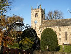
St Oswald's Church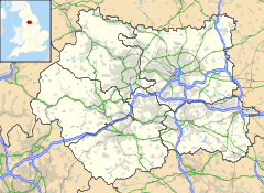
 Collingham
Collingham shown within West YorkshirePopulation 2,967 OS grid reference SE3845 Parish Collingham Metropolitan borough City of Leeds Metropolitan county West Yorkshire Region Yorkshire and the Humber Country England Sovereign state United Kingdom Post town WETHERBY Postcode district LS22 Dialling code 01937 Police West Yorkshire Fire West Yorkshire Ambulance Yorkshire EU Parliament Yorkshire and the Humber UK Parliament Elmet List of places: UK • England • Yorkshire Collingham is a village and civil parish 2 miles (3 km) south east of Wetherby in West Yorkshire, England. It is in the City of Leeds metropolitan borough. The clergyman, the Reverend William Mompesson was born there in 1639.[1]
The River Wharfe runs through the village towards Wetherby, as does the main A58 trans-Pennine road. The A659 passes through the village. The River Wharfe is particularly dangerous at Collingham due to undercurrents, which are especially prevalent around the Linton Road Bridge and the former viaduct. Collingham Beck burst its banks in 2007, causing extensive flooding.
The village has two pubs, the Old Star Inn [1] and the Half Moon Inn [2], where Oliver Cromwell is said to have spent the night after the Battle of Marston Moor.[2] There is a Post Office, a variety of shops and service businesses, a sports centre and a primary school. The village church is St Oswald.[3]
The village school, Lady Elizabeth Hastings Church of England Primary School,[4] is located off the Harewood Road opposite the cricket pitch.
The Wetherby golf course extends all the way to the river at Collingham.
 The Wharfe passing between Linton and Collingham
The village adjoins the neighbouring village of Linton and the neighbouring town of Wetherby. Between the three places, the only break in buildings is the crossing over the River Wharfe. Between Collingham and Leeds, the A58 is mainly built up by the villages of Bardsey and Scarcroft and the village of Bardsey cum Rigton.
Collingham is home to Collingham and Linton Cricket Club which plays in the Airedale-Wharfedale Senior Cricket League.[5] This is located at the Collingham and Linton Sports Association (CALSA), which boasts three indoor squash courts, a football pitch and a cricket pitch. CALSA also has affiliated tennis and hockey sections.
Collingham once had a railway station on the Cross Gates to Wetherby line. The station was named 'Collingham Bridge' to avoid confusion with Collingham railway station in Collingham, Nottinghamshire and was the station before Wetherby railway station. The railway bridge over the River Wharfe, which once ran adjacent to the Linton road bridge (pictured left) was demolished in 1965 when the railway was dismantled. Collingham is now served by the 98, X98 and 99 bus services which run between Leeds City Square and Wetherby Deighton Bar (each running a slightly different route, the 99 terminating instead at Wetherby bus station). These services are run by First Leeds.
Contents
Amenities
 The Old Star
The village has one pub, The Half Moon on Harewood Road. On Main Street there is an Italian restaurant, Picolino. The Squash club also has a licensed bar & Sky Sports.
Set within a small modern shopping precinct Elizabeth Court are most of the village shops. There is an off licence, a fish and chip shop, a travel agency, a pharmacy, delicatessen, a clothes shop, a bathroom shop, a dentist, a dry cleaner, a deli as well as other shops. Adjacent is a small parade of shops containing a convenience store and a newsagent and Post Office. In addition there is a GP's surgery providing NHS services and a variety of non-NHS services such as private medical examination reports.
Collingham's amenities are complemented by the wide range of amenities available in Wetherby. Wetherby has a large flagship Morrisons supermarket as well as two Co-ops and a Sainsbury's. There are many High Street retailers (Marks and Spencer, Boots the Chemist, Superdrug, Costa Coffee etc) and a wide variety of pubs, bars, cafes and restaurants. Wetherby is a five minute ride on the bus.
Collingham has an Anglican church and a small Methodist chapel. There are Catholic services in neighbouring Bardsey and Wetherby. In line with many areas in England, attendances at these churches in recent years has fallen, despite a slow growth in population.
Housing and buildings
 Elizabeth Court, Eastern Parade
 Elizabeth Court, Western Parade
 Collingham memorial hall
Much of the centre of Collingham was demolished in the 1960s and 1970s and replaced with modern facilities. However the Elizabeth Court Shopping Precinct in Collingham is stone-built and sympathetically styled. As part of this, many small shops and cottages were demolished, changing the character of the village. Some small cottages were purchased by the Half Moon public house, demolished and are now a large car park. The village has two churches. A large Anglican church and a small, unremarkable Methodist chapel. There is a 1960s-built primary school, a 1970s-built indoor squash courts.
There is an eclectic mix of Georgian, Victorian and Twentieth century housing. Collingham has some Council Housing, mainly on Brookside and Garth End. Housing around Harewood Road is generally large, detached late twentieth century housing. Housing around Leeds Road is mainly ex-council housing (although not actually on Leeds Road itself), while housing on Wetherby Road is generally the oldest in Collingham. There has been no housing development on a notable scale in Collingham, since Bryant Homes built housing along Linton Lane. Planning Applications have been put forward for conversion of the villages former garden centre into flats. However this scheme has stalled and been revised to contain only two houses. Along with the nearby Old Star the garden centre site is boarded up and surrounded by security fencing (garden centre).
Flooding
Collingham has had persistent problems with mild flooding and was affected by the 2007 UK Floods. The River Wharfe usually keeps within its banks during heavy rain, however the Collingham Beck has a tendency to swell very quickly. During the 2007 UK Floods it flooded Millbeck Green and much of the A58 Leeds Road as well as reaching the boundaries of the Half Moon and Old Star public houses. As of May 2008, a few residents were still unable to return to their homes. One house was looted during the floods.
2008 Burglary Spate
Collingham,like most areas, has suffered from burglaries in the past, however in 2008 the village suffered an unprecedented spate of burglaries leading to a constant police presence in the village.[6][7] In a four month period from July to November 2008, 63 domestic break-ins were reported in the village as well as numerous thefts of and from vehicles.
Governance
See also: Local government in LeedsCollingham falls into the Elmet and Rothwell constituency, which is currently held by Alec Shelbrooke (Conservative). Collingham falls under the 'Parish Council of Collingham and Linton', which is under the governance of Leeds City Council. The nearest council offices are in Wetherby. Collingham was until 1974 in the Wetherby Rural District, it is now in the Harewood Ward of the City of Leeds.
Nearby Settlements
Location grid

Wetherby Harewood 
Boston Spa  Collingham, West Yorkshire

Bardsey References
External links
- "The Ancient Parish of Collingham". GENUKI. http://www.genuki.org.uk/big/eng/YKS/WRY/Collingham/index.html. Retrieved 2007-10-29.
Categories:- Places in Leeds
- Villages in West Yorkshire
- Civil parishes in West Yorkshire


Wikimedia Foundation. 2010.