- Arizona State Route 82
Infobox road
marker_
state=AZ
highway_name=
name_notes=
type=state
route=82
alternate_name=
maint=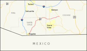
length_mi=65.74
length_round=2
length_ref=cite web |url=http://tpd.az.gov/data/reports/2006SHSLog.pdf |title=2006 ADOT Highway Log |author=Arizona Department of Transportation |accessdate=2008-04-09]
length_notes=
established=
decommissioned=
direction_a=West
starting_terminus=jct|state=AZ|BL|19|dab1=Nogales in Nogales
junction=
direction_b=East
ending_terminus=jct|state=AZ|SR|80 near Tombstone
previous_type=AZ
previous_route=81
next_type=AZ
next_route=83
commons=State Route 82 (SR 82) is an east-west state highway in southern
Arizona .Route description
The western terminus of SR 82 is located at its junction with Business Loop 19 (Grand Avenue) in Nogales and its eastern terminus at its junction with State Route 80 just north of Tombstone. Between Nogales and Patagonia, it is also known as Patagonia Road and Patagonia Highway. Other than the aforementioned locations, State Route 82 also travels through Sonoita and Whetstone, and is one of the few major east-west highways in its service area. The highway also serves as access to Patagonia Lake State Park, Nogales International Airport, wineries of Southern Arizona near Elgin and Sonoita and followed an abandoned rail line between Patagonia and Tombstone.
Junction list
References

Wikimedia Foundation. 2010.