- Oklahoma City metropolitan area
-
Greater Oklahoma City 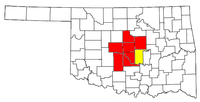
Common name: Oklahoma City Metro AreaLargest city Oklahoma City Other cities - Norman
- Edmond
- ShawneePopulation Ranked 44th in the U.S. - Total 1,322,459 (2010 Census) - Density 208.0/sq. mi.
80.1/km²Area 6,359 sq. mi.
16,512 km²State(s) Oklahoma Elevation - Highest point ?1 feet (?1 m) - Lowest point ?1 feet (?1 m) The Oklahoma City Metropolitan Area is a large urban region located in the central part of the state of Oklahoma. It is often known as the Oklahoma City Metro or Greater Oklahoma City, and contains the state capital and principal city, Oklahoma City.
Seven counties make up the Oklahoma City Metroplex: Canadian, Cleveland, Grady, Lincoln, Logan, McClain, and Oklahoma. The region had 1,227,278 residents in 2009[2].
The micro urban area of Shawnee (in Pottawatomie County) is included in Oklahoma City's Combined Statistical Area (CSA) which brings the region's population to 1,322,429. The Oklahoma City – Shawnee CSA is also included as part of the I-35 Megalopolis.
Contents
- 1 Cities and towns comprising the Oklahoma City Metropolitan Area
- 2 Metro-area suburbs and exurbs
- 3 References
Cities and towns comprising the Oklahoma City Metropolitan Area

Kingfisher
PiedmontGuthrie
EdmondChandler
JonesEl Reno
Yukon
Bethany
Del City
Midwest City
Choctaw
Shawnee OKLAHOMA CITY

Mustang
ChickashaMoore
NormanMetro-area suburbs and exurbs
The following communities are suburbs and exurbs of Oklahoma City with populations of at least 1,000 found within the bounds of State Highway 33 to the north, State Highway 18 and US-177 to the east, State Highway 39 and State Highway 9 to the south, and US-81 to the west.
North of Oklahoma City
Nichols Hills and The Village
These are separate small cities, surrounded by Oklahoma City. Nichols Hills, just north of Belle Isle, is an enclave of the affluent with many historic homes, upscale shops, and some of the metro's best restaurants. The Village, immediately north, is a middle class post-World War II neighborhood where property values have increased in recent years due to its proximity to Lake Hefner and Nichols Hills neighborhoods.
Edmond
Main article: Edmond, OklahomaEdmond is a suburb of 75,000 people northeast of and adjacent to Oklahoma City. The famous U.S. Route 66 ran through downtown Edmond before turning southward into Oklahoma City. Edmond is a pioneer in Oklahoma education, with the University of Central Oklahoma (1890), the state's first place of higher education, and the first public school building constructed in the state. Edmond was also home to the first Junior League Roller Derby Team, The Snooty Dogs. Edmond is the hometown of 1996 Olympic gold medal-winner Shannon Miller as well as the alternative rock band Andeline. Edmond is one of the fastest growing cities in Oklahoma. This area of the metro has great access to the Broadway Extension and I-35.
Guthrie
Guthrie the first capital of the State of Oklahoma, lies to the north of Edmond in Logan County. Guthrie is home to the drive-in theater used in the movie Twister, as well as some Victorian homes, which tend to be uncommon in Oklahoma. Recently, Guthrie and Edmond formed a pact to create the Edmond-Guthrie Regional Airport.
Northeast of Oklahoma City
Jones
Jones is a small community of around 2,500 situated a few miles south of I-44. Its location east of Edmond is isolated and hilly, but convenient to Oklahoma City at large.
Chandler
Chandler is a city of about 3,000 located east of Edmond and north Oklahoma City on U.S. Route 66 and Interstate 44 and north of Shawnee on Highway 18 in Lincoln County. The Turner Turnpike (I-44) provides commuters and shoppers easy access to Oklahoma City.
Located along the famous U.S. Route 66, Chandler is rich with Route 66 history and a popular stop on cruises and biker runs.
Chandler offers a number of attractions to devotees of "The Mother Road". These include The Route 66 Interpretive Center, The Oklahoma Law Enforcement Museum and Hall of Fame, The Lincoln County Museum of Pioneer History, several Route 66-themed murals, the newly restored old cottage-style Phillips 66 gas station, P.J.'s Bar-B-Que, and the last remaining painted barn adverting Meramec Caverns west of town. Other attractions in Chandler include the Lincoln County Farmers Market and the annual Ice Cream Festival in the summer.
Chandler is experiencing growth, including the opening of a Wal-Mart Supercenter, addition of new banks and restaurants, and construction of upscale housing out of city limits.
East of Oklahoma City
Choctaw, Harrah, Nicoma Park, Spencer, and Meeker
Main article: Choctaw, OK
Strung out along US-62 to the east of Oklahoma City are Choctaw, Harrah, Nicoma Park, Spencer, and Meeker. These towns are not as densely populated as Oklahoma City, but as with most other areas that surround The City, they are experiencing rapid growth.
Meeker was home to "King" Carl Hubbell, an American baseball player and Hall of Famer.
Del City
Main article: Del CityBordered by southeast Oklahoma City and adjacent to Tinker Air Force Base, Del City is home to just under 23,000 residents.[1] The city maintains a strong link to the military, serving as home to many base personnel and military retirees. After facing hard times due to regional economic decline and the devastating effects of the May 3, 1999 tornado, Del City is experiencing a period of significant growth and redevelopment. A new Wal-Mart Supercenter and several new chain stores serve as the groundwork for future economic development. Continued expansion at several major employers, including the opening of the international corporate headquarters of Midwest Trophy/MTM Recognition and dramatic expansion at Mayco (oil field parts) are bringing quality jobs to the city. Easy commuting access to Interstate 40 and Interstate 35, strong community organizations and neighborhood watch groups, and affordable housing prices make Del City particularly attractive to young families. Del City High School has received many state and national awards, including the Class 4-A (at the time, the state's largest high school athletics division) State Football Championship in 1974. Del City has worked to create recreational opportunities for residents that include walking and bicycling on several sections of improved trail, picnic areas at Ray Trent Park, or fishing at Eagle Lake. Two recreational facilities, the Eagle Harbor Aquatics Center and the Wiggly Field Dog Park, are recognized as being among the best of their kind. Del City is also the hometown of two-time Olympic Gold medalist John Smith.[2]
Midwest City
Main article: Midwest CityMidwest City, with 55,000 people, is a mix of middle class post-war housing and upscale newer housing, based largely around the sprawling Tinker Air Force Base. The eastern part of the city is home to generally newer housing additions built in the past two decades. City leaders have enjoyed success in reinventing their downtown area, and attracting numerous eateries and shops to the Town Center Plaza, a new shopping center along Interstate 40 anchored by Lowe's, Target, and J.C. Penney locations. The city's dying mall, Heritage Park, has planned a large-scale renovation. In the late 1990s the mall slowly started losing tenants, and what once was a thriving mall had turned into a collection of "mom-and-pop" stores. By 2006, it was left with two anchor stores – Sears and Dillard's – but Dillard's closed in March 2006, leaving the mall with even less traffic than before. The city boasts a junior college, Rose State, and much of the metro's automobile market. The devastation from the May 3, 1999 tornado opened the door to new development of numerous hotels and the Reed Convention Center, which is connected to a Sheraton hotel. Midwest City is a wrestling and football powerhouse with its 15 state wrestling titles and five state football championship wins.
Southeast of Oklahoma City
Shawnee
Shawnee, Oklahoma is an exurb of Oklahoma City, somewhat removed from the immediate metropolitan area by its isolation, which has about 30,000 people and is home to two colleges. St. Gregory's University, the first college in Oklahoma, is a liberal arts school which in 2000 began granting baccalaureate degrees. Oklahoma Baptist University, also a liberal arts institution, was founded in 1910. The historic downtown area has seen a flurry of redevelopment, including the conversion of the vacant Aldridge Hotel into a large apartment building.
Bethel Acres, Tecumseh, McLoud, and Pink
These communities are exurbs of Oklahoma City and form a micropolitan area with Shawnee.
South of Oklahoma City
Valley Brook
Valley Brook is a small town of less than 1,000 nestled into Oklahoma City's south side. It has somewhat relaxed laws for strip clubs compared to the rest of the metro, and several are prominently advertised on nearby I-35.
Moore
Moore surrounds I-35 between Oklahoma City and Norman, and is rapidly growing both south towards Norman and north towards the increasingly affluent southwest area of Oklahoma City. Moore's population is approaching 55,000 people, and there is massive commercial development under construction along the freeway at S. 19th St. Residential additions have been recently built on the eastern and western edges of the city limits, with more planned. Moore's school district supports three high schools, Moore, Westmoore, and Southmoore. Country music star Toby Keith is a Moore native.
Norman
 Buchanan Street in Norman
Norman, Oklahoma is the anchor city of the south Oklahoma City Metropolitan Area and has a growing full-time population of over 106,000 residents, making it the state's third-largest city. Norman is home to the University of Oklahoma, the state's largest university. Norman is a combination of a well-established "college town," historic neighborhoods among the state's oldest, 1950's-era middle-class areas, and newer developments mostly on the town's north side. Always a hub of alternative music, Norman was home to indie rockers the Chainsaw Kittens and was a starting place for international super stars the Flaming Lips. Norman is also the hometown of movie star James Garner and country music star Vince Gill.
Noble, Purcell, Lexington, and Slaughterville
These four suburbs/exurbs lie south of Norman along the I-35 and US-77 corridors. Multi-million dollar horse farms give the area much commerce and appearance of great wealth. Steady growth continues, although not as rapid as the southwest metro, it is growing in popularity with new residents seeking acreages and small school systems as numbers of Norman residents experience changing dynamics of traffic, and crowded schools, stores that follow rapid population growth.
Noble is known as the "Rose-Rock Capital of the World" for its abundance of soil-bound barium sulfate. Slaughterville was thrust into the public spotlight by a recent campaign by PETA to change the name of the town to "Veggieville," though the town was named after a James Slaughter, not for the killing of animals.
Purcell, OK was founded as a railroad town in 1887, with the coming of the Atchison, Topeka and Santa Fe Railroad and is the retail hub of 21,300 residents including several surrounding communities including Criner, Payne, Wayne, Washington and Woody Chapel and surrounding unincorporated rural areas of McClain County as well as Lexington in southern Cleveland County. (per 2010 census numbers)
Goldsby and Washington
These small communities lie along I-35 just west of the South Canadian River. Goldsby is known for its Chickasaw Nation casinos: Goldsby Gaming Center, and the recently opened Riverwind Casino, which is currently the largest casino in Oklahoma.
Southwest of Oklahoma City
Newcastle, Tuttle, Blanchard, and Bridge Creek
Traveling along I-44 southwest from the City takes one into the fastest-growing part of the metro, which is known as "Tri-City" after its major constituents: Newcastle, Oklahoma, Tuttle, Oklahoma, and Blanchard, Oklahoma. The area surrounds the tiny town of Bridge Creek. These suburbs have experienced rapid growth over the past 5–10 years as the result of people moving further from downtown Oklahoma City with an estimated combined population of 21,374 (2010 census). Though these communities have suffered growing pains, the increased residential and business development is improving the governments' abilities to improve the infrastructure needs while increasing services available. Newcastle serves as the epicenter of business development for the region but all of the communities are seeing growth in these arenas.
Tornados: Bridge Creek suffered incredible damage in the May 3 Tornado of 1999. Blanchard and Newcastle suffered damages in the Tornadoes of May 24, 2011 with the loss or damages of over 350 homes and over 20 businesses, thankfully no lives were lost.
Chickasha
Chickasha, an exurb of Oklahoma City, is located along I-44 southwest of the City. With over 17,000 people, Chickasha is home to the University of Science and Arts of Oklahoma, the state's only public liberal arts institution.
West of Oklahoma City
Bethany and Warr Acres
Bethany and Warr Acres are located in the suburban inner western part of the city and are largely surrounded by parts of Oklahoma City proper. These suburbs are home to the metro's most competitive tax rates, and have attracted numerous big box retailers. There are a large number of historic motels, restaurants, and bars along old Route 66 (now NW 39th St). Lake Overholser, the city's oldest lake, is surrounded by upscale housing and has recently seen proposals for resort development on its shores. There are growing Korean, East Indian, and Pakistani communities in this area.
Bethany is home to Southern Nazarene University and Southwestern Christian University and has a small, well-preserved main street area along 39th Street near the SNU campus. Unique compared to other suburbs, these suburban "enclaves" have a stagnant population.
Mustang
The eastern Mustang city limits are cut off from the rest of the metro by Will Rogers World Airport, which makes Mustang one of the most remote areas in the metro. Mustang Schools service a large area outside Mustang limits into Oklahoma City, which surrounds Mustang completely. The city of about 17,200 is rapidly growing and until recently could sometimes not be found on maps.
Yukon and El Reno
Yukon, the home of Garth Brooks and Cross Canadian Ragweed, is a growing suburb located 13 miles (21 km) west of downtown on I-40 and the recently completed West Loop of Kilpatrick Turnpike. The city is currently in the midst of a population and retail boom.
El Reno, named after Fort Reno which once stood there, is an active Main Street community. The Oklahoma Main Street Program is a downtown revitalization program. El Reno was formerly a Certified City and has successfully transitioned to a Century Community. Also notable in El Reno is the trolley that runs through the downtown area.
Minco and Union City
These small, rural communities are located south of I-40 along US-81 in Grady and Canadian Counties, respectively, between El Reno and Chickasha.
Northwest of Oklahoma City
Piedmont
Piedmont is the fastest-growing city in the metro. While it is rapidly approaching some 5,300 residents, it has retained a small-town/rural feel overall. It is located just a few miles north of the intersection of State Highway 3 and State Highway 4 (at the north end of the latter), north of Yukon.
Cashion and Okarche
The towns of Cashion and Okarche are located on the northwestern fringes of the metro area. Both towns lie in two counties: Cashion (Kingfisher and Logan) and Okarche (Kingfisher and Canadian). Cashion and Okarche are located primarily in Kingfisher County, which is a rural county. The Logan County portion of Cashion and the Canadian County portion of Okarche, however, do lie within the defined boundaries of the Oklahoma City MSA.[3]
Towns with fewer than 1,000 people
There are many towns in the Oklahoma City MSA with less than 1,000 population.
- Arcadia
- Calumet
- Cedar Valley
- Cimarron City
- Fallis
- Forest Park
- Lake Aluma
- Luther
- Newalla
- Smith Village
- Warwick
- Wayne
- Wellston
- Woodlawn Park
In 2005, Hall Park was annexed by Norman and ceased to be a town, becoming instead a group of housing subdivisions.
References
- ^ American FactFinder U.S. Census Bureau (accessed February 4, 2010).
- ^ About Us, City of Del City. [1] (accessed January 13, 2010)
- ^ "Update of Statistical Area Definitions and Guidance on Their Uses". Office of Management and Budget. December 6, 2009. http://www.whitehouse.gov/omb/assets/bulletins/b10-02.pdf. Retrieved May 31, 2010.
50 largest metropolitan statistical areas in the United States by population - New York
- Los Angeles
- Chicago
- Dallas–Fort Worth
- Philadelphia
- Houston
- Washington
- Miami
- Atlanta
- Boston
- San Francisco–Oakland
- Detroit
- Riverside–San Bernardino
- Phoenix
- Seattle
- Minneapolis–St. Paul
- San Diego
- St. Louis
- Tampa–St. Petersburg
- Baltimore
- Memphis
- Louisville
- Richmond
- Oklahoma City
- Hartford
- New Orleans
- Buffalo
- Raleigh
- Birmingham
- Salt Lake City
Categories:- Oklahoma City Metropolitan Area
- Metropolitan areas of Oklahoma

Wikimedia Foundation. 2010.