- Atlas
An atlas is a collection of
map s, typically of Earth or a region of Earth, but there are atlases of the other planets (and their satellites) in the solar system. Atlases have traditionally been bound into book form, but today many atlases are inmultimedia formats. In addition to presentinggeographic features andpolitical boundaries, many atlases often featuregeopolitical ,social ,religious andeconomic statistics .History
[
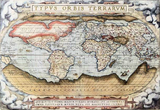
thumb|333px|World_map_from_the_first_modern_atlas_by_Ortelius - "Theatrum Orbis Terrarum " (1570)] The earliest atlases were not called by that name at the time of their publication, as it was introduced in 1595 byGerardus Mercator .The first book that in hindsight could be called an atlas was constructed from the calculations of
Claudius Ptolemy , ageographer working inAlexandria circa A.D. 150. The first edition was published inBologna in 1477 and was illustrated with a set of 27 maps, though scholars say that it is not known whether the printed maps were engraved versions of original maps made by Ptolemy, or whether they were constructed by medieval Greek scholars from Ptolemy's text.From about 1544, many maps were produced, especially in the important trading centers of
Rome andVenice . Each publisher worked independently, producing maps based upon their own needs. The maps often varied dramatically in size. Over time, it became common to bind the maps together into composite works. Although the term atlas was not in use in 1544, these works are now called "IATO" atlases - (Italian, Assembled to Order) or more frequently "Lafreri atlases " after one of the leading publishers of the period.Abraham Ortelius is credited with issuing the first modern atlas onMay 20 ,1570 . His "Theatrum Orbis Terrarum ", contained 53 map-sheets covering the countries of the World. This work was the first book of its kind to reduce the best available maps to a uniform size. It was an immediate critical and commercial success.However, use of the word "atlas" for a bound collection of maps was not to come into use until the 1595 publication of Gerardus Mercator's "Atlas, Sive Cosmographicae Meditationes De Fabrica Mundi ..." (Atlas, or Description of the Universe) (Duisburg, 1585-1595).
"Atlas" etymology
The origin of the term atlas is a common source of misconception, perhaps because two different mythical figures named 'Atlas' are associated with mapmaking.
*King Atlas, a mythical King of
Mauretania , was, according to legend, a wise philosopher, mathematician and astronomer who supposedly made the first celestial globe. It was this Atlas that Mercator was referring to when he first used the name 'Atlas', and he included a depiction of the King on the title-page.
*However, the more widely known Atlas is a figure fromGreek mythology . He is the son of the Titan Iapetus andClymene (or Asia), and brother ofPrometheus . Atlas was punished byZeus and made to bear the weight of the heavens (the idea of Atlas carrying the Earth isn't correct according to the original myth) on his back. One of Heracles's labours was to collect the apples of the Hesperides. Heracles went to Atlas and reasoned with him. Eventually, Atlas agreed to collect the apples, and Heracles was left to carry the weight. Atlas tried to leave Heracles there, but Heracles tricked him and Atlas was left to carry the heavens forever. In his epicOdyssey ,Homer refers to this Atlas as "one who knows the depths of the whole sea, and keeps the tall pillars who hold heaven and earth asunder".In works of art, this Atlas is represented as carrying the heavens or the
Celestial Sphere , on his shoulders. The earliest such depiction is theFarnese Atlas , now housed at theMuseo Archeologico Nazionale Napoli inNaples, Italy . This figure is frequently found on the cover or title-pages of atlases. This is particularly true of atlases published by Dutch publishers during the second half of the seventeenth century. The image became associated with Dutch merchants, and a statue of this figure adorns the front of the World Trade Center inAmsterdam .The first publisher to associate the Titan Atlas with a group of maps was Lafreri, on the title-page to "Tavole Moderne Di Geografia De La Maggior Parte Del Mondo Di Diversi Autori ...". However, he did not use the word "atlas" in the title of his work.
Modern atlases
With the coming of the global market, publishers in different countries can reprint maps from plates made elsewhere. This means that the place names on the maps often use the designations or abbreviations of the language of the country in which the feature is located, to serve the widest market. For example, islands near Russia have the abbreviation "O." for "ostrov", not "I." for "island". This practise differs from what is standard for any given language, and it reaches its extremity concerning
transliteration s from other languages. Particularly, German mapmakers use the transliterations from Cyrillic developed by the Czechs which are hardly used in English-speaking countries.elected general atlases
Some cartographically or commercially important atlases include the following:
;17th century and earlier
*"Atlas Novus " (Blaeu, Netherlands, 1635-1658)
*"Atlas Maior " (Blaeu, Netherlands, 1662-1667)
*"Cartes générales de toutes les parties du monde" (France, 1658-1676)
*"Dell'Arcano del Mare " (England/Italy, 1645-1661)
*"Piri Reis Map " (Ottoman Empire, 1570-1612)
*"Theatrum Orbis Terrarum " (Ortelius, Netherlands, 1570-1612);18th century
*"Atlas Nouveau" (Amsterdam, 1742)
*"Britannia Depicta" (London, 1720)
*"Cary's New and Correct English Atlas" (London, 1787);19th century
*"Andrees Allgemeiner Handatlas " (Germany, 1881-1939; in the UK as "Times Atlas of the World ", 1895)
*"Rand McNally Atlas" (United States, 1881-present)
*"Stielers Handatlas " (Germany, 1817-1944);20th century
*"Atlante Internazionale del Touring Club Italiano " (Italy, 1927-1978)
*"Atlas Mira " (Russia, 1937-present)
*"Gran Atlas Aguilar " (Spain, 1969/1970)
*"Historical Atlas of China " (China)
*"National Geographic Atlas" of the World (United States, 1963-present)
*"Pergamon World Atlas " (1962/1968)
*"Times Atlas of the World " (United Kingdom, 1895-present)See also
*
Bird atlas
*Cartography
*Cartopedia
*Cybercartography
*Geography
*Google Maps
*Manifold
*NASA World Wind
*Star atlas
*TerraServer-USA
*Theatrum Orbis Terrarum External links
Sources
* [http://www.mapforum.com/01/atlas.htm On the origin of the term "Atlas"]Online atlases
* [http://www.homemade-atlas.org/ Homemade Atlas of the World]
* [http://www.geographynetwork.com/ Geography Network]
* [http://gos2.geodata.gov/wps/portal/gos Geospatial One-Stop]
* [http://www.earthatlas.mapchart.com MapChart EarthAtlas] , free online atlas with interactive maps about topics like demography, economy, health and environment.
* [http://www.expedia.com/pub/agent.dll?qscr=mmfn Microsoft/Encarta/Expedia World atlas] , world atlas, plus atlas for North America and Europe to street level.
* [http://www.multimap.com/ Multimap World atlas] : on UK, US, Canada, Australia and Western Europe more detailed than the rest of the world
* [http://www.nationalatlas.gov/ National Atlas of the United States]
* [http://plasma.nationalgeographic.com/mapmachine/ National Geographic MapMachine]
* [http://www.freeworldmaps.net/ Physical Atlas of the World] Online world atlas with physical maps
* [http://tirolatlas.uibk.ac.at/ Tirolatlas] Online atlas of North-, South- and Eastern-Tyrol (Austria), requires SVG capabilities in the browser.
* [http://go.hrw.com/atlas/norm_htm/ World atlas by country]History of atlases
* [http://www.loc.gov/rr/geogmap/guide/gmillatl.html Atlases, at the US Library of Congress site] - a discussion of many significant atlases, with some illustrations. Part of [http://www.loc.gov/rr/geogmap/guide/gmilltoc.html Geography and Maps, an Illustrated Guide.]Historical atlases online
* [http://www.library.ucla.edu/yrl/reference/maps/blaeu/ 1645 Latin edition of Blaeu's Atlas] atUCLA (partial copy)
* [http://www.davidrumsey.com/atlases.html Atlases at DavidRumsey.com] includes many important atlases from the 18th-20th centuries, primarily fromFrance ,Germany , theUnited Kingdom and theUnited States .
* [http://www.HistoricalAtlas.com/ Centennia Historical Atlas] required reading at the US Naval Academy for over a decade.
* [http://digitalgallery.nypl.org/nypldigital/explore/dgexplore.cfm?topic=printing&collection_list=AmericanShoresMapsfr&col_id=149 Charting North America] , maps and atlases in the New York Public Library Digital Collection
* [http://www.terra.es/personal7/jqvaraderey/index.html Historical and Political Maps of the Modern Age]
* [http://www.atlas-historique.net/ Historical Atlas from 1815 till today, "in French"]
* [http://www.euratlas.com/summary.htm Historical Atlas of Europe from AD 1 to 2000]
* [http://www.lib.utexas.edu/maps/map_sites/hist_sites.html Historical map web sites list] , Perry-Castañeda Library, University of Texas
* [http://www.maphistory.info/imageworld.html maphistory.info links]
* [http://www.stub.unibe.ch/stub/ryhiner/collection/progress.html Ryhiner Collection] Composite atlas with maps, plans and views from the 16th-18th centuries, covering the globe, with about 16,000 images in total.
* [http://www.zum.de/whkmla/histatlas/haindex.html World History Maps at KMLA]Other links
* [http://atlasworld.info Atlas World:] a directory of atlases currently in print.
* [http://earth.google.com Google Earth:] a visual 3D interactive atlas.
* [http://www.instantatlas.com InstantAtlas] Create your own interactive atlas for any area.
* [http://maps.live.com Live Maps:] 2D and 3D interactive maps.
* [http://www.map.ox.ac.uk Malaria Atlas Project] .
* [http://learn.arc.nasa.gov/worldwind/index.html NASA's World Wind software] .
* [http://www.na.unep.net/OnePlanetManyPeople/index.php One Planet, Many People] UN Atlas of the Human impact on the Environment.
* [http://eusoils.jrc.it/projects/soil_atlas Soil Atlas of Europe] .
* [http://www.wikimapia.org/#lat=19.4342&lon=-99.1386&z=3&l=0&m=a&v=2 Wikimapia] a wikiproject designed to describe the entire world.
* [http://www.world-atlas.biz World Atlas]
Wikimedia Foundation. 2010.