- Dunnellon/Marion County Airport
-
Dunnellon/Marion County Airport & Park of Commerce 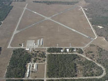
IATA: none – ICAO: none – FAA LID: X35 Summary Airport type Public Owner Dunnellon Airport Authority Serves Dunnellon, Florida Elevation AMSL 65 ft / 20 m Coordinates 29°03′42″N 082°22′36″W / 29.06167°N 82.37667°W Runways Direction Length Surface ft m 5/23 4,941 1,506 Asphalt 9/27 4,702 1,433 Asphalt Statistics (2008) Aircraft operations 15,000 Based aircraft 52 Source: Federal Aviation Administration[1] 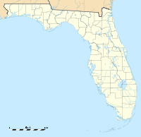
 Dunnellon/Marion County AirportLocation of Dunnellon/Marion County Airport, Florida
 Emblem of I Troop Carrier Command
 Emblem of Air University
 1949 airphoto of Dunnellon Airport
Dunnellon/Marion County Airport and Park of Commerce (FAA LID: X35) is a public use airport located four nautical miles (7 km) east of the central business district of Dunnellon, in Marion County, Florida, United States. The airport is owned by Dunnellon Airport Authority.[1] It is also known as the Dunnellon/Marion County Airport, Dunnellon Airport and Marion County Airport.
Originally set on 500 acres (2 km²) that was purchased in 1942 by Marion County, the airport encompasses 1,706 acres (6.90 km2) (6.9 km²) of land. One runway was closed in the 1990s, reducing the airport to its current two. With new security fencing, electrical gates, a snack bar and additional T-hangars, the airport is not projected to require major expansion through 2020. The facility is located 38 miles (61 km) south of Gainesville Regional Airport. Services available include 24-hour fuel, major airframe powerplant servicing. During 2006, the airport averaged 41 flights per day.
Contents
History
The airport was opened in August 1942, by the United States Army Air Forces. Known as Dunnellon Army Air Base it was assigned to the I Troop Carrier Command as a training Airfield. The 10th Troop Carrier Group used the airfield to train C-47 Skytrain troop carrier groups between 13 February-30 November 1943. The 27th and 436th Troop Carrier Squadrons of the 10th Troop Carrier Group flying C-47 Skytrains were assigned to the base in 1943. Also, the 317th and 318th Troop Carrier Commando Units were assigned to the base during 1944.[2][3][4][5][6]
Troop Carrier units continued to train at Dunnellon throughout the war receiving training as C-47 pilots and crewmen of the British-design Airspeed Horsa glider. Graduates saw duty in North Africa, Europe, and the China-Burma-India Theater in this capacity.
In August 1943, control of Dunnellon was reassigned to the Air University's Army Air Forces School of Applied Tactics (AAFSAT) tactical combat simulation school in Central and Northern Florida.
AAFSAT reassigned the 420th Night Fighter Squadron, a night fighter Operational Training Unit (OTU) to Dunnellon with a mission to train pilots with night fighting skills for defensive missions against enemy night intruder aircraft. The squadron was equipped with modified Douglas A-20 Havocs for night fighter operations, designated P-70s.
Night fighter training was undertaken until January 1944, when the USAAF program was reassigned to IV Fighter Command, and the school was moved to Hammer Field, California.
With the departure of the P-70s, I Troop Carrier Command returned to the airfield, the base being turned into a Troop Carrier Commando training base. The commando squadrons remained until September 1944 when they moved out for combat duties in the Philippines. Afterwards activity at the base were phased down.
Control was deeded to Marion County following the end of the war, with the facility being renamed the Dunnellon/Marion County Airport & Park of Commerce.
Facilities and aircraft
Dunnellon/Marion Co. & Park of Commerce Airport covers an area of 1,706 acres (690 ha) at an elevation of 65 feet (20 m) above mean sea level. It has two asphalt paved runways: 5/23 is 4,941 by 100 feet (1,506 x 30 m) and 9/27 is 4,702 by 60 feet (1,433 x 18 m).[1]
For the 12-month period ending April 21, 2008, the airport had 15,000 general aviation aircraft operations, an average of 41 per day. At that time there were 52 aircraft based at this airport: 80.8% single-engine, 9.6% multi-engine and 9.6% ultralight.[1]
The airport also has a full service flight school, Whiskey Bravo Air. www.whiskeybravoair.com
See also
- Florida World War II Army Airfields
- Army Air Force School of Applied Tactics
References
- ^ a b c d FAA Airport Master Record for X35 (Form 5010 PDF). Federal Aviation Administration. Effective 8 April 2010.
- ^ USAFHRA Document 00073753
- ^ USAFHRA Document 00092233
- ^ USAFHRA Document 00077691
- ^ USAFHRA Document 00075841
- ^ USAFHRA Document 00075819
Other sources
 This article incorporates public domain material from websites or documents of the Air Force Historical Research Agency.
- Maurer, Maurer (1983). Air Force Combat Units Of World War II. Maxwell AFB, Alabama: Office of Air Force History. ISBN 0-89201-092-4.
- Mauer, Mauer (1969), Combat Squadrons of the Air Force, World War II, Air Force Historical Studies Office, Maxwell AFB, Alabama. ISBN 0-89201-097-5
- Shaw, Frederick J. (2004), Locating Air Force Base Sites History’s Legacy, Air Force History and Museums Program, United States Air Force, Washington DC, 2004.
External links
- Dunnellon/Marion County Airport and Park of Commerce at Marion County web site
- Aerial image as of 5 January 1999 from USGS The National Map
- FAA Terminal Procedures for X35, effective 20 October 2011
- Resources for this airport:
- AirNav airport information for X35
- FlightAware airport information and live flight tracker
- SkyVector aeronautical chart for X35
Categories:- 1942 establishments
- Airfields of the United States Army Air Forces I Troop Carrier Command
- Airfields of the United States Army Air Forces in Florida
- Airports in Florida
- Army Air Forces School of Applied Tactics Airfields
- Transportation in Marion County, Florida
- Buildings and structures in Marion County, Florida


Wikimedia Foundation. 2010.