- Cocos (Keeling) Islands
-
"Cocos Islands" redirects here. It is not to be confused with Cocos Island or Coco Islands.Territory of the Cocos (Keeling) Islands


Flag Motto: Maju Pulu Kita 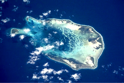 NASA picture of the southern Cocos (Keeling) Islands.
Capital West Island Largest village Bantam (Home Island) Official language(s) English (de facto) Demonym Cocossian (Cocos Islandian) Government Federal constitutional monarchy - Queen Elizabeth II - Administrator Brian Lacy - Shire President Aindil Minkom Territory of Australia - Annexed by
British Empire
1857- Transferred to
Australian control
1955Area - Total 14 km2
5.3 sq mi- Water (%) 0 Population - July 2009 estimate 596[1] (n/a) - Density 43/km2 (n/a)
112/sq miCurrency Australian dollar ( AUD)Time zone (UTC+06:30) ISO 3166 code CC Internet TLD .cc Calling code 61 891 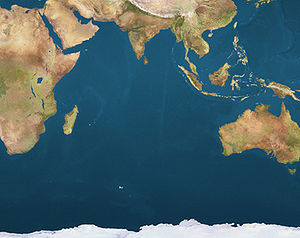
 CocosLocation of Cocos Islands in the Indian Ocean
The Territory of the Cocos (Keeling) Islands, also called Cocos Islands and Keeling Islands, is a territory of Australia, located in the Indian Ocean, southwest of Christmas Island and approximately midway between Australia and Sri Lanka.
The territory consists of two atolls and 27 coral islands, of which two, West Island and Home Island, are inhabited with a total population of approximately 600.
Contents
Geography
The Cocos (Keeling) Islands consist of two flat, low-lying coral atolls with an area of 14.2 square kilometres (5.5 sq mi), 26 kilometres (16 mi) of coastline, a highest elevation of 5 metres (16 ft) and thickly covered with coconut palms and other vegetation. The climate is pleasant, moderated by the southeast trade winds for about nine months of the year and with moderate rainfall.[citation needed] Cyclones may occur in the early months of the year.
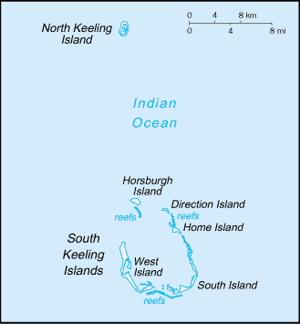
North Keeling Island is an atoll consisting of just one C-shaped island, a nearly closed atoll ring with a small opening into the lagoon, about 50 metres (160 ft) wide, on the east side. The island measures 1.1 square kilometres (270 acres) in land area and is uninhabited. The lagoon is about 0.5 square kilometres (120 acres). North Keeling Island and the surrounding sea to 1.5 km (0.93 mi) from shore form the Pulu Keeling National Park, established on 12 December 1995. It is home to the only surviving population of the endemic, and endangered, Cocos Buff-banded Rail.
South Keeling Islands is an atoll consisting of 24 individual islets forming an incomplete atoll ring, with a total land area of 13.1 square kilometres (5.1 sq mi). Only Home Island and West Island are populated. The Cocos Malays maintain weekend shacks, referred to as pondoks, on most of the larger islands.
Table of the islets, with areas, numbered islets clockwise starting in the north:
 Cocos (Keeling) Islands.
 Map of South Keeling Islands (1889)
 Map of South Keeling Islands
Nr. Islet
(Malay name)English name Area
(km²)1 Pulau Luar Horsburgh Island 1.04 2 Pulau Tikus Direction Island 0.34 3 Pulau Pasir Workhouse Island <0.01 4 Pulau Beras Prison Island 0.02 5 Pulau Gangsa Woeplace Islets <0.01 6 Pulau Selma Home Island 0.95 7 Pulau Ampang Kechil Scaevola Islet <0.01 8 Pulau Ampang Canui Island 0.06 9 Pulau Wa-idas Ampang Minor 0.02 10 Pulau Blekok Goldwater Island 0.03 11 Pulau Kembang Thorn Island 0.04 12 Pulau Cheplok Gooseberry Island <0.01 13 Pulau Pandan Misery Island 0.24 14 Pulau Siput Goat Island 0.10 15 Pulau Jambatan Middle Mission Isle <0.01 16 Pulau Labu South Goat Island 0.04 17 Pulau Atas South Island 3.63 18 Pulau Kelapa Satu North Goat Island 0.02 19 Pulau Blan East Cay 0.03 20 Pulau Blan Madar Burial Island 0.03 21 Pulau Maria West Cay 0.01 22 Pulau Kambling Keelingham Horn Island <0.01 23 Pulau Panjang West Island 6.23 24 Pulau Wak Bangka Turtle Island 0.22 There are no rivers or lakes on either atoll. Fresh water resources are limited to water lenses on the larger islands, underground accumulations of rainwater lying above the seawater. These lenses are accessed through shallow bores or wells.
Cocos (Keeling) Island is located on almost exactly the opposite side of the globe from Cocos Island, Costa Rica.
Fauna
Main article: Fauna of the Cocos (Keeling) IslandsDemographics
In 2010, the population of the islands is estimated at just over 600.[2] The population on the two inhabited islands generally is split between the ethnic Europeans on West Island (estimated population 100) and the ethnic Malays on Home Island (estimated population 500). A Cocos dialect of Malay and English are the main languages spoken, and 80% of Cocos Islanders are Sunni Muslim.
History
In 1609 Captain William Keeling was the first European to see the islands, while serving in the East India Company,[3] but they remained uninhabited until the 19th century.
In 1814, a Scottish merchant seaman named Captain John Clunies-Ross stopped briefly at the islands on a trip to India, nailing up a Union Jack and planning to return and settle on the islands with his family in the future.[3]
However, a wealthy Englishman named Alexander Hare had similar plans, and hired a captain, coincidentally Clunies-Ross' brother, to bring him and a harem of forty Malay women to the islands where he hoped to set up his own private residence.[3] Hare had previously served as governor of a colony in Borneo and found that "he could not confine himself to the tame life that prosy civilisation affords".[3]
When Clunies-Ross returned two years later with his wife, children and mother-in-law, and found Hare already established on the island and living with a private harem, a feud grew instantly between the two men.[3] Clunies-Ross' eight sailors, "began at once the invasion of the new kingdom to take possession of it, women and all".[3]
After some time, Hare's women began deserting him, and instead finding themselves mates amongst Clunies-Ross' sailors.[4] Disheartened, Hare left the island and went to Batavia where he later died.[3]
Clunies-Ross' workers were paid in a currency called the Cocos rupee, a currency John Clunies-Ross minted himself that could only be redeemed at the company store.[5]
 An 1840 chart of the Cocos (Keeling) Islands
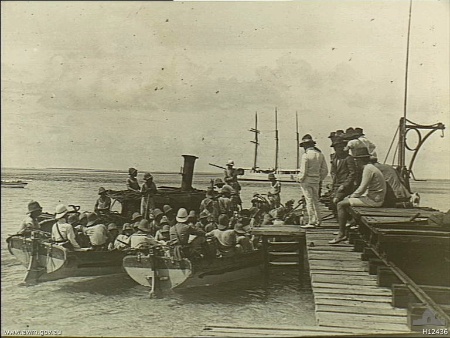
 A landing party from the German Navy cruiser Emden leaves Cocos (Keeling) Islands via this jetty on Direction Island.
On 1 April 1836, HMS Beagle under Captain Robert FitzRoy arrived to take soundings establishing the profile of the atoll as part of the survey expedition of the Beagle. To the young naturalist Charles Darwin, who was on the ship, the results supported a theory he had developed of how atolls formed, which he later published as The Structure and Distribution of Coral Reefs. He studied the natural history of the islands and collected specimens.[6] Darwin's assistant Syms Covington noted, "an Englishman [he was of course Scottish] and HIS family, with about sixty or seventy mulattos from the Cape of Good Hope, live on one of the islands. Captain Ross, the governor, is now absent at the Cape."
Annexed to the British Empire
The islands were annexed by the British Empire in 1857. This annexation was carried out by Captain Stephen Grenville Fremantle in command of HMS Juno. Fremantle claimed the islands for the British Empire and appointed Ross II as Superintendent.[7] In 1867, their administration was placed under the Straits Settlements, which included Penang, Malacca and Singapore. Queen Victoria granted the islands in perpetuity to the Clunies-Ross family in 1886. The Cocos Islands under the Clunies-Ross family have been cited as an example of a 19th-century micronation.[citation needed]
World War I
On 9 November 1914, the islands became the site of the Battle of Cocos, one of the first naval battles of World War I. The wireless telegraph station on Direction Island, a vital link between the United Kingdom, Australia and New Zealand, was destroyed by sailors from the German light cruiser SMS Emden, which was in turn surprised and destroyed by the Australian cruiser, HMAS Sydney.[8]
World War II
During World War II, the cable station was once again a vital link. Allied planners noted that the islands might be seized as a base for German raider cruisers operating in the Indian Ocean. Following Japan's entry into the war, Japanese forces did occupy neighbouring islands. To avoid drawing their attention to the Cocos cable station and its islands' garrison, the seaplane anchorage between Direction and Horsburgh islands was not used. Radio transmitters were also kept silent, except in emergencies.[citation needed]
After the Fall of Singapore in 1942, the islands were administered from Ceylon (Sri Lanka), and West and Direction Islands were placed under Allied military administration. The islands' garrison initially consisted of a platoon from the British Army's King's African Rifles, located on Horsburgh Island, with two 6-inch (152.4 mm) guns to cover the anchorage. The local inhabitants all lived on Home Island. Despite the importance of the islands as a communication centre, the Japanese made no attempt either to raid or to occupy them and contented themselves with sending over a reconnaissance aircraft about once a month.[citation needed]
On the night of 8–9 May 1942, 15 members of the garrison, from the Ceylon Defence Force, mutinied, under the leadership of Gratien Fernando. The mutineers were said to have been provoked by the attitude of their British officers, and were also supposedly inspired by anti-imperialist beliefs. They attempted to take control of the gun battery on the islands. The Cocos Islands Mutiny was crushed, although the mutineers killed one non-mutinous soldier and wounded one officer. Seven of the mutineers were sentenced to death at a trial which was later alleged to have been improperly conducted. Four of the sentences were commuted, but three men were executed, including Fernando. These were to be the only British Commonwealth soldiers executed for mutiny during the Second World War.[9]
On 25 December 1942, the Japanese submarine planned reinvasion of Malaya and reconquest of Singapore. The first aircraft to arrive were Supermarine Spitfire Mk VIIIs of No. 136 Squadron RAF. They included some Liberator bombers from No. 321 (Netherlands) Squadron RAF (members of exiled Dutch forces serving with the Royal Air Force), which were also stationed on the islands. When in July 1945 No. 99 and No. 356 RAF squadrons arrived on West Island, they brought with them a daily newspaper called Atoll which contained news of what was happening in the outside world. Run by airmen in their off-duty hours, it achieved fame when dropped by Liberator bombers on POW camps over the heads of the Japanese guards. In 1946 the administration of the islands reverted to Singapore.[citation needed]
Transfer to Australia
On 23 November 1955, the islands were transferred to Australian control under the Cocos (Keeling) Islands Act 1955 (an Australian Act) pursuant to the Cocos Islands Act, 1955 (a UK Act).[11] Mr H J Hull was appointed the first Official Representative (now Administrator) of the new Territory. He had been a Lieutenant- Commander in the Royal Australian Navy and was released for the purpose. Under Commonwealth Cabinet Decision 1573 of 9 September 1958, Mr Hull's appointment was terminated and John William Stokes was appointed on secondment from the Northern Territory Police. A media release at the end of October 1958 by the Minister for Territories, Mr Hasluck, commended Mr Hull's three years of service on Cocos. Mr Stokes served in the position from 31 October 1958 to 30 September 1960. Mr C.I. Buffett MBE from Norfolk Island succeeded him and served from 28 July 1960 to 30 June 1966, and later acted as Administrator back on Cocos and on Norfolk Island. In 1974, Ken Mullen wrote a small book[12] about his time with wife and son from 1964 to 1966 working at the Cable Station on Direction Island.
In the 1970s, the Australian government's dissatisfaction with the Clunies-Ross feudal style of rule of the island increased. In 1978, Australia forced the family to sell the islands for the sum of A$6,250,000, using the threat of compulsory acquisition. By agreement, the family retained ownership of Oceania House, their home on the island. However, in 1983 the Australian government reneged this agreement, and told John Clunies-Ross that he should leave the Cocos. The following year the High Court of Australia ruled that resumption of Oceania House was unlawful, but the Australian government ordered that no government business was to be granted to Clunies-Ross's shipping company, an action that contributed to his bankruptcy. John Clunies-Ross now lives in Perth, Western Australia. However, some members of the Clunies-Ross family still live on the Cocos.
The 2004 earthquake and tsunami centered off the western shore of Sumatra, Indonesia, prompted early worries about the Cocos, but no casualties were reported.[13]
Government
The capital of the Territory of Cocos (Keeling) Islands is West Island while the largest settlement is the village of Bantam[citation needed] (Home Island). Governance of the islands is based on the Cocos (Keeling) Islands Act 1955[14][15] and depends heavily on the laws of Australia. The islands are administered from Canberra by the Attorney-General's Department[16] (before 29 November 2007[17] administration was carried out by the Department of Transport and Regional Services), through a non-resident Administrator appointed by the Governor-General.
The current Administrator is Brian Lacy, who was appointed on 18 September 2009 and is also the Administrator of Christmas Island. These two Territories comprise Australia's Indian Ocean Territories. There also exists a unicameral Cocos (Keeling) Islands Shire Council with seven seats. A full term lasts four years, though elections are held every two years; approximately half the members retire each two years. Federally, Cocos (Keeling) Islanders form the electorate of Lingiari with Christmas Island and outback Northern Territory.
The islands have a five-person police force but their defence remains the responsibility of Australia.[2]
Economy
There is a small and growing tourist industry focused on water-based or nature activities.
Small local gardens and fishing contribute to the food supply, but most food and most other necessities must be imported from Australia or elsewhere.
The Cocos Islands Cooperative Society Ltd. employs construction workers, stevedores, and lighterage worker operations. Tourism employs others. The unemployment rate was 11.3% in 2006.[18]
Communications and transport
The islands are connected within Australia's telecommunication system (with number range +61 8 9162 xxxx) and postal system (post code: 6799). Public phones are located on both West Island and Home Island. A GSM mobile phone network operates on Cocos (Keeling) Islands which is "on its last legs" according to the Government.[19] Phones must be registered through the Telecentre to access this service. There is one paved airport on the West Island, Cocos (Keeling) Island International Airport, to which Virgin Australia operates scheduled jet services from Perth, Western Australia. There is also a lagoon anchorage.
In the 1950s and 1960s the airport at Cocos Islands was a key stop for commercial airline flights between Australia and South Africa, and Qantas and South African Airways stopped there to refuel. The arrival of long range jet aircraft ended this requirement.
Media
Cocos (Keeling) Islands has access to a range of modern communication services. Four television stations broadcast from Western Australia via satellite. These are ABC, SBS, WIN and GWN. A local radio station, 6CKI – Voice of the Cocos (Keeling) Islands, is staffed by community volunteers and provides some local content.As television and radio stations broadcast through a satellite service, rainfall may cause interference.
Television
Cocos Island received four channels from Western Australia via Satellite:
- ABC1
- SBS One
- WIN Television (Affiliated of Nine Network Perth)
- GWN7 (Affiliated of Seven Network Perth)
Cocos Island only receives four channels because digital television is not available yet.
Education
There are two schools in the archipelago, located on the two inhabited islands. One is on West Island, and the other on Home Island.
School instruction is in English, and efforts are made to discourage students from speaking the local language (Cocos Islands Malay, a Malay dialect) on school premises.[20]
Gallery
-

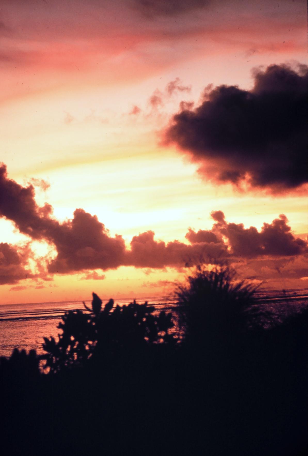
Sunset over the islands
-

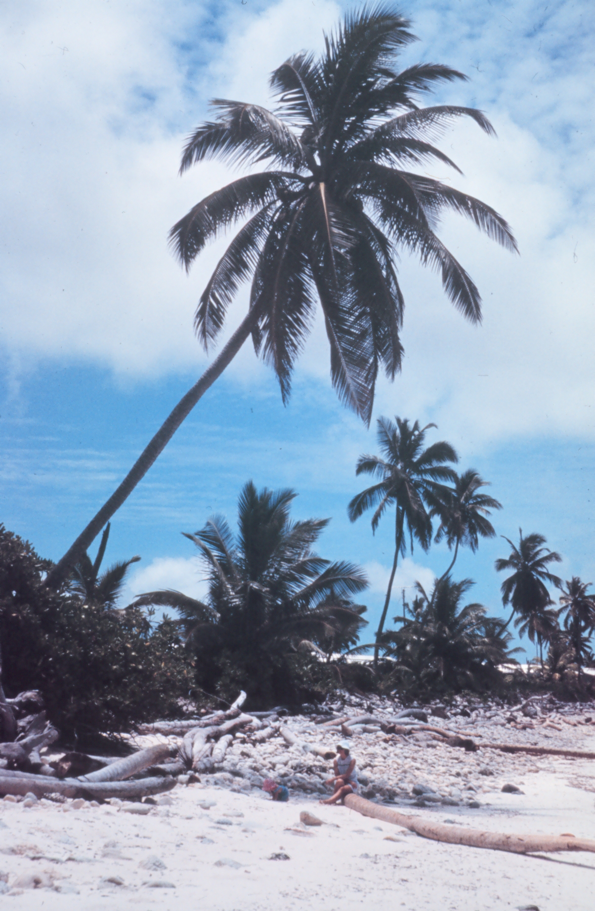
Palm trees on the islands
See also
- Index of Cocos (Keeling) Islands-related articles
- Banknotes of the Cocos (Keeling) Islands
- Cocos Malays
- King of the Cocos (Keeling) Islands
- Pearl Islands Isla de Cocos, Panama and Cocos Island, Costa Rica
- Transport in the Cocos (Keeling) Islands
References
- ^ Cocos (Keeling) Islands, The World Factbook, CIA. Accessed 14 April 2009.
- ^ a b CIA World Factbook
- ^ a b c d e f g Joshua Slocum, "Sailing Alone Around the World", p. 212
- ^ The Clunies-Ross Chronicle
- ^ End of a kingdom
- ^ Keynes, Richard (2001), Charles Darwin's Beagle Diary, Cambridge University Press, pp. 413–418
- ^ "The Cocos Islands". The Chambers's Journal 76: 187–190. 1899. http://books.google.com/books?id=ddUXAQAAIAAJ&pg=PA187.
- ^ "HMAS Sydney (I)". Royal Australian Navy. http://www.navy.gov.au/w/index.php/HMAS_Sydney_%28I%29. Retrieved 23 August 2008.
- ^ Cruise, Noel (2002). The Cocos Islands Mutiny. Fremantle: Fremantle Arts Centre Press. pp. 248. ISBN 1 86368 310 0.
- ^ Combinedfleet.com
- ^ Parliamentary Debates, House of Commons, 28 June 1977.
- ^ Cocos Keeling, the islands time forgot (1974). Ken Mullen. published by Angus & Robertson, Sydney. 122 pages.
- ^ Main article: Countries affected by the 2004 Indian Ocean earthquake
- ^ WebLaw – full resource metadata display
- ^ ComLaw Act Compilations – Cocos (Keeling) Islands Act 1955 (34)
- ^ First Assistant Secretary, Territories Division (30 January 2008). "Territories of Australia". Attorney-General's Department. http://www.ag.gov.au/territories. Retrieved 7 February 2008. "The Federal Government, through the Attorney-General's Department administers Ashmore and Cartier Islands, Christmas Island, the Cocos (Keeling) Islands, the Coral Sea Islands, Jervis Bay, and Norfolk Island as Territories."
- ^ Department of Infrastructure, Transport, Regional Development and Local Government. "Territories of Australia". Archived from the original on December 16, 2007. http://web.archive.org/web/20071216154140/http://www.infrastructure.gov.au/territories/index.aspx. Retrieved 7 February 2008. "As part of the Machinery of Government Changes following the Federal Election on 29 November 2007, administrative responsibility for Territories has been transferred to the Attorney General's Department."
- ^ 2006 Census, Australian Bureau of Statistics
- ^ APH.gov.au
- ^ Paige Taylor, Crime in paradise lost in translation "The Australian", 17 August 2009
External links
- Shire of Cocos (Keeling) Islands homepage
- Areas of individual islets
- Atoll Research Bulletin vol. 403
- Cocos (Keeling) Islands Tourism website
- Cocos (Keeling) Islands entry from the CIA World Factbook
- Noel Crusz, The Cocos Islands mutiny, Reviewed by: Peter Stanley, Principal Historian, Australian War Memorial
- History of Cocos (Keeling) Islands
- The man who lost a "coral kingdom"
Coordinates: 12°07′S 96°54′E / 12.117°S 96.9°E
Australia related History of Australia States Territories - Australian Capital Territory
- Jervis Bay Territory
- Northern Territory
External territories - Ashmore and Cartier Islands
- Australian Antarctic Territory
- Christmas Island
- Cocos (Keeling) Islands
- Coral Sea Islands
- Heard Island and McDonald Islands
- Norfolk Island
Geography of Australia States - New South Wales
- Queensland
- South Australia
- Tasmania
- Victoria
- Western Australia
Territories - Australian Capital Territory
- Jervis Bay Territory
- Northern Territory
External territories - Ashmore and Cartier Islands
- Australian Antarctic Territory
- Christmas Island
- Cocos (Keeling) Islands
- Coral Sea Islands
- Heard Island and McDonald Islands
- Norfolk Island
States and territories of Australia States and mainland
territories
External territories Former territories Asia related Geography of Asia Sovereign
states- Afghanistan
- Armenia
- Azerbaijan
- Bahrain
- Bangladesh
- Bhutan
- Brunei
- Burma (Myanmar)
- Cambodia
- People's Republic of China
- Cyprus
- East Timor (Timor-Leste)
- Egypt
- Georgia
- India
- Indonesia
- Iran
- Iraq
- Israel
- Japan
- Jordan
- Kazakhstan
- North Korea
- South Korea
- Kuwait
- Kyrgyzstan
- Laos
- Lebanon
- Malaysia
- Maldives
- Mongolia
- Nepal
- Oman
- Pakistan
- Philippines
- Qatar
- Russia
- Saudi Arabia
- Singapore
- Sri Lanka
- Syria
- Tajikistan
- Thailand
- Turkey
- Turkmenistan
- United Arab Emirates
- Uzbekistan
- Vietnam
- Yemen
States with limited
recognition- Abkhazia
- Nagorno-Karabakh
- Northern Cyprus
- Palestine
- Republic of China (Taiwan)
- South Ossetia
Dependencies and
other territoriesIslands of Singapore Natural Pedra Branca · Pulau Anak Bukom · Pulau Bajau · Pulau Berkas · Pulau Biola (Violin Island) · Pulau Brani · Pulau Buaya · Pulau Bukom / Pulau Bukum · Pulau Bukom Kechil/Pulau Bukum Kechil · Pulau Buloh · Pulau Busing · Pulau Damar Laut · Pulau Damien · Pulau Hantu (Ghost Island) · Pulau Jong (Junk Island) · Pulau Keppel · Pulau Ketam · Pulau Khatib Bongsu · Pulau Malang Siajar · Pulau Palawan · Pulau Pawai · Pulau Pergam · Pulau Renggis · Pulau Sakijang Bendera (St. John's Island) · Pulau Sakijang Pelepah (Lazarus Island) · Pulau Salu · Pulau Samulun · Pulau Sarimbun · Pulau Satumu (One Tree Island) · Pulau Sebarok (Middle Island) · Pulau Seletar · Pulau Semakau · Pulau Senang (Barn Island) · Pulau Sekudu (Frog Island) · Pulau Selugu (Sarong Island) · Pulau Serangoon (Coney Island) · Pulau Seringat · Pulau Seringat Kechil · Pulau Subar Darat (Sisters' Islands) · Pulau Subar Laut (Sisters' Islands) · Pulau Sudong · Pulau Tekong · Pulau Tekukor · Pulau Tembakul (Kusu Island / Peak Island) · Pulau Ubin · Pulau Ular · Pulau Unum · Sentosa · Singapore (Pulau Ujong) · Sultan ShoalArtificial Chinese Garden · Coral Island · Japanese Garden · Jurong Island · Kias Island · Paradise Island · Pearl Island · Pulau Punggol Barat · Pulau Punggol Timor · Sandy Island · Treasure IslandFormer Anak Pulau · Berhala Reping · Pulau Ayer Chawan · Pulau Ayer Merbau · Pulau Bakau · Pulau Darat · Pulau Merlimau · Pulau Mesemut Darat · Pulau Mesemut Laut · Pulau Meskol · Pulau Pesek · Pulau Pesek Kecil · Pulau Saigon · Pulau Sejahat · Pulau Sejahat Kechil · Pulau Sakeng / Pulau Seking · Pulau Sakra · Pulau Sanyongkong · Pulau Semechek · Pulau Seraya · Pulau Tekong Kechil · Terumbu Retan LautNo longer part of Singapore Christmas Island · Cocos (Keeling) IslandsCountries and other territories in Southeast Asia Sovereign states Dependent territories - Christmas Island, Australia
- Cocos (Keeling) Islands, Australia
Subdivisions - Andaman and Nicobar Islands, India
- Hainan, PRC
- Paracel Islands, PRC
- Pratas Islands, ROC
- Spratly Islands
- (Taiping Island, ROC)
Climate of Asia Sovereign
states- Afghanistan
- Armenia
- Azerbaijan
- Bahrain
- Bangladesh
- Bhutan
- Brunei
- Burma (Myanmar)
- Cambodia
- People's Republic of China
- Cyprus
- East Timor (Timor-Leste)
- Egypt
- Georgia
- India
- Indonesia
- Iran
- Iraq
- Israel
- Japan
- Jordan
- Kazakhstan
- North Korea
- South Korea
- Kuwait
- Kyrgyzstan
- Laos
- Lebanon
- Malaysia
- Maldives
- Mongolia
- Nepal
- Oman
- Pakistan
- Philippines
- Qatar
- Russia
- Saudi Arabia
- Singapore
- Sri Lanka
- Syria
- Tajikistan
- Thailand
- Turkey
- Turkmenistan
- United Arab Emirates
- Uzbekistan
- Vietnam
- Yemen
States with limited
recognition- Abkhazia
- Nagorno-Karabakh
- Northern Cyprus
- Palestine
- Republic of China (Taiwan)
- South Ossetia
Dependencies and
other territories- Christmas Island
- Cocos (Keeling) Islands
- Hong Kong
- Macau
Language related Austronesian-speaking countries and territories Formosan Malayo-Polynesian American Samoa · Brunei · Burma (Myanmar) · Cambodia · Christmas Island · Cocos (Keeling) Islands · Cook Islands · Easter Island · East Timor · Fiji · French Polynesia · Guam · Hainan · Indonesia · Kiribati · Madagascar · Malaysia · Marshall Islands · FS Micronesia · Nauru · New Caledonia · New Zealand · Niue · Northern Mariana Islands · Orchid Island · Palau · Papua New Guinea · Philippines · Samoa · Singapore · Solomon Islands · Sri Lanka · Suriname · Tokelau · Tonga · Tuvalu · United States (Hawaii) · Vanuatu · Vietnam · Wallis and FutunaEnglish-speaking world Click on a coloured region to get related article:
Countries and territories where English is the national language or the native language of the majority.
Africa Americas Anguilla · Antigua and Barbuda · The Bahamas · Barbados · Bermuda · British Virgin Islands · Canada · Cayman Islands · Dominica · Falkland Islands · Grenada · Guyana · Jamaica · Montserrat · Saba · Saint Kitts and Nevis · Saint Lucia · Saint Vincent and the Grenadines · Sint Eustatius · Sint Maarten · South Georgia and the South Sandwich Islands · Trinidad and Tobago · Turks and Caicos Islands · United States · United States Virgin IslandsEurope Oceania Countries and territories where English is an official language, but not the majority language.
Africa Americas Asia Europe Oceania American Samoa · Christmas Island · Cocos (Keeling) Islands · Cook Islands · Fiji · Guam · Kiribati · Marshall Islands · Micronesia · Nauru · Niue · Northern Mariana Islands · Palau · Papua New Guinea · Pitcairn Islands · Samoa · Solomon Islands · Tokelau · Tuvalu · VanuatuCategories:- Cocos (Keeling) Islands
- Archipelagoes of the Indian Ocean
- British rule in Singapore
- States and territories of Australia
- States and territories established in 1955


Wikimedia Foundation. 2010.