- Chibu, Shimane
-
Chibu
知夫村— Village — Village of Chibu An aerial view of Chibu.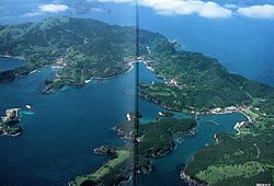

SealChibu shown in red, cities shown in green, and towns shown in yellow. Location of Chibu in Japan
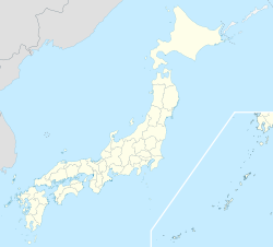
 Chibu
ChibuCoordinates: 36°0′51.14″N 133°2′22.55″E / 36.0142056°N 133.0395972°ECoordinates: 36°0′51.14″N 133°2′22.55″E / 36.0142056°N 133.0395972°E Country Japan Prefecture Shimane District Oki Settled 2000 BCE[1] Incorporated (district) 600 CE[1] Incorporated (village) 600 CE Neighborhoods List- Kōri (郡)
- Nibu (仁夫)
- Ōe (大江)
- Tataku (多沢)
- Usuge (薄毛)
- Kurii (来居)
- Urumi (古海)
Area[2] – Total 13.70 km2 (5.3 sq mi) – Land 13.70 km2 (5.3 sq mi) Highest elevation 325 m (1,066 ft) Lowest elevation 0 m (0 ft) Population (2010)[3] – Total 657 – Estimate (March 2011[4]) 656 – Density 48/km2 (124.2/sq mi) Time zone Osaka, Sapporo, Tokyo (UTC09:00) Postal code 684-0100 Phone 08514-8-2211 Address 1065 Kōri, Chibu-mura, Oki-gun, Shimane-ken 684-0102 Address (Japanese) 〒684-0102島根県隠岐郡知夫村郡1065番地 Website http://www.chibu.jp Chibu (知夫村 Chibu-mura, Chibu-son) is a village located on Chiburi Island (知夫里島 Chiburi-jima) in the Douzen group of islands in the Oki District, Shimane, Japan. Chibu is the only village remaining in Shimane Prefecture as of October 1, 2005.
As of Japan's 2010 census,[3] the village has a population of 657 people, constituting 326 households, and a density of about 48 persons per km². This is a decrease of 68 people (9.4%) from the previous census conducted in 2005.[2] A population estimate from March 2011[4] placed Chibu's population at 656 people, 334 men and 322 women.
Contents
Geography and climate
Geography
Chibu is located on Chiburi Island (知夫里島 Chiburi-jima), the smallest of the Douzen group of islands. These islands were formed from a single ancient volcanic island. The caldera of the volcano collapsed, leaving three islands in a ring formation.[5]
Chiburi Island is generally mountainous, but the south central area is somewhat flat. There are a number of sea cliffs, particularly on the western side of the island which faces the open expanse of the Sea of Japan. The elevation of Chiburi Island ranges from 0m (at sea-level) to 325m. The island has a land-area of approximately 13.7 km2. This includes 18 smaller uninhabited islands located near Chiburi Island.[1] The island's two most well-known natural features are Mount Akahage (アカハゲ山 Akahage-yama) and Akakabe (赤壁 Akakabe, Sekiheki is an alternative reading). Akakabe is a unique sea-cliff in Oki composed of red rock.
The Village of Chibu is composed of 7 smaller neighborhoods, called chiku (地区) in Japanese. These neighborhoods are Kōri (郡), Nibu (仁夫), Ōe (大江), Tataku (多沢), Usuge (薄毛), Kurii (来居), and Urumi (古海). The village is served by a sea port located in Kurii which provides ship transportation among the 3 islands of Douzen, to Okinoshima, and to the mainland. There is also a heliport for medical emergencies.
Climate
Chibu Climate chart (explanation) J F M A M J J A S O N D 116829671104113105167131201217224172272721124292321125181072012122157124114Average max. and min. temperatures in °C Precipitation totals in mm Source: JMA Ama Station[6] Imperial conversion J F M A M J J A S O N D 4.546353.845344.151374.160455.268546.874628.980714.984738.377644.269534.860454.95139Average max. and min. temperatures in °F Precipitation totals in inches As an island located in the Sea of Japan, Chibu is within the Sea of Japan climate zone. Summers temperatures, though usually mild, are exacerbated by high humidity. Winter temperatures are also generally mild, though exacerbated by strong wind. The surrounding ocean has a warming effect, making winters milder than the mainland. Consequently, there is very little snow on Chibu, and what snow does fall usually melts quickly.
The nearest weather station is located on the nearby island of Ama. Chibu's average annual high and low temperatures are 17.6°C (64°F) and 10.5°C (51°F), with yearly mean of 14.4°C (58°F). The record high and low temperatures are 34.9°C (95°F) and -2.9°C (27°F) respectively. The average yearly humidity is 76%. Chibu receives an average of 1,662 mm (65.43 in) of precipitation a year.
Climate data for Village of Chibu (1979-2000) Month Jan Feb Mar Apr May Jun Jul Aug Sep Oct Nov Dec Year Record high °C (°F) 17.2
(63.0)19.0
(66.2)22.9
(73.2)26.2
(79.2)30.4
(86.7)31.0
(87.8)33.8
(92.8)34.9
(94.8)32.9
(91.2)30.0
(86.0)23.3
(73.9)18.6
(65.5)34.9
(94.8)Average high °C (°F) 7.5
(45.5)7.3
(45.1)10.5
(50.9)15.8
(60.4)20.2
(68.4)23.5
(74.3)26.8
(80.2)28.9
(84.0)25.1
(77.2)20.3
(68.5)15.3
(59.5)10.5
(50.9)17.6 Daily mean °C (°F) 4.9
(40.8)4.5
(40.1)7.1
(44.8)12.0
(53.6)16.4
(61.5)20.2
(68.4)24.1
(75.4)25.8
(78.4)21.6
(70.9)16.3
(61.3)11.8
(53.2)7.6
(45.7)14.4 Average low °C (°F) 1.8
(35.2)1.0
(33.8)2.7
(36.9)7.3
(45.1)12.1
(53.8)16.8
(62.2)21.4
(70.5)22.5
(72.5)17.7
(63.9)11.7
(53.1)7.4
(45.3)3.8
(38.8)10.5 Record low °C (°F) −0.6
(30.9)−2.9
(26.8)2.3
(36.1)6.0
(42.8)11.8
(53.2)15.6
(60.1)19.3
(66.7)21.4
(70.5)17.9
(64.2)10.9
(51.6)6.3
(43.3)1.5
(34.7)−2.9
(26.8)Precipitation mm (inches) 115.5
(4.547)96.4
(3.795)104.3
(4.106)105.2
(4.142)131.0
(5.157)171.9
(6.768)227.0
(8.937)124.0
(4.882)211.0
(8.307)107.4
(4.228)121.7
(4.791)123.8
(4.874)1,662.0
(65.433)% humidity 72 72 72 73 75 82 84 81 80 75 73 72 76 Avg. precipitation days 5.25 4.38 4.74 4.48 5.95 7.81 10.32 5.53 9.59 4.88 5.53 5.63 75.5 Sunshine hours 54.3 67.5 123.4 181.1 198.8 140.2 156.8 210.3 140.8 141.1 91.4 68.4 1,574.5 Source no. 1: JMA Ama Station[6] Source no. 2: JMA Saigo Station[7] History
The earliest evidence of human habitation of Chibu is the tomb called Himemiya Shrine Ruins (姫宮神社遺跡 Himemiya-jinja iseki) located in Urumi. The tomb is dated to the Jōmon period, 4000 years before present. Other ancient tombs built in the Yayoi (2300 BP) and Kofun (1700 BP) periods were also found. Also, the Oki Islands, including Chiburi Island, are mentioned in Japan's two most ancient texts, Kojiki and Nihon Shoki. In the Asuka period, the area became incorporated into the "Chibu district" (知夫郡 Chibu-gun) encompassing both Chiburi Island and Nishinoshima.[1]
Etymology of Chiburi Island and Chibu
Over time, Chibu and Chiburi Island (知夫里島 Chiburi-jima) have been written with various different kanji. These include the following, all of which are read "Chiburi": 知夫里, 知夫, 知夫利, 智夫, 道触 (see below), 知振, 千振, and 千波. There are two different theories regarding the name "Chiburi Island".[8]
The first and most likely is that the name came from the name of a Shinto god enshrined on Chiburi Island's Watatsu Island (渡津島 Watatsu-jima). The god, called Chiburi no kami (道触の神), is a god protecting ships.[9] Since Chiburi Island is the closest to the mainland of the Oki Islands, ships coming to and departing from Oki would stop on Chiburi Island and ask the god for a safe voyage. Over time, the name "Chiburi" stuck and the island became known as "Chiburi Island" from whence the name "Chibu Village" was derived.[8][10]
The second theory is that the name came from the use of smoke signals sent between Chiburi Island and the mainland for communication. Since Chiburi Island is the closest, it was the easiest to see between the Oki Islands and the mainland.
Culture and Recreation
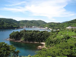 The main populated area of Chibu.
 "Swimming cows" are a kind of tourist attraction. The cows are pulled out into the water and released. They then swim back to the shore.
Government
The government of Chibu is organized with the mayor at the top, followed by the vice-mayor, treasurer, and 4 department chiefs, in that order. There is also a village board of 8 members elected for 4-year terms. The mayor of Chibu is elected for a 4-year term. The vice-mayor is appointed by the mayor and approved by the village board. The mayor and vice-mayor, as of November 2008, are Mr. Tatsuo Yada and Mr. Nobuyuki Watanabe, respectively. The board of education operates independently of the normal village office structure. The chief of the board of education is also appointed by the mayor and approved by the village board.
Festivals and events
- Amasashi hiko no mikoto jinja reisai (天佐志比古命神社例祭)
- is a festival held bi-annually, usually at the end of July. This festival is common throughout Japan, and the main event is carrying a mikoshi through the town. The home temple for this is Chibu's Ikū Shrine (一宮神社 Ikū-jinja). Another common event during this festival is kodomo kabuki, or children's kabuki. Chibu's tradition has it that there was once a serious sickness on Chibu, and, after it passed, dances and kabuki were performed by children in celebration.
- Odaishi-san mawari (お大師さん回り)
- is a festival that was celebrated commonly across Japan in the past, but is recently becoming rarer. In the past, a famous monk named Kōbō-Daishi traveled throughout Japan and founded many temples. The festival started as a way for people to "copy" him by visiting various small temples in their town. Usually food is available at each location for visitors. The food is made by married women who often start preparing the food early in the morning. In Chibu, this festival is usually held in April.
- Jyamaki (蛇巻き)
- is an event that, like Odaishi-san mawari, was more common in the past, but is less common now. A rope (or "snake") is braided from dried rice-straw, and wrapped around a tree. This for good luck in the year's harvest, and usually is done in the fall.
- Nodaikon matsuri (野大根祭り)
- is a festival held in April for a beef-cattle show and to kick off the tourist season. Typical events in the festival are a cow show, karaoke contest, performances by elementary and kindergarten children, local folk songs called min'yō (民謡), and occasionally hired music talent. Festival food is also sold such as Oki beef, oysters, and yakisoba.
- Minna ichi taiko (皆一太鼓)
- is a small traditional festival not unique to Chibu held in October for good luck in the harvest and safety for marine vessels. Drums are played and a dance is performed to send luck to the town.
- Bunkasai (文化祭) and Undō no hi (運動の日)
- are common events throughout Japan usually held in November and October, respectively. In many other places, towns and schools may hold their own separate events. However, on Chibu the village and school combine because of the small population.
Trivia

- Chibu is the only village in Shimane-ken since October 1, 2005.
- Chibu is the only island of the Oki Islands with tanuki. There are only about 600 people but probably more than 2000 tanuki.[11]
- In 2008, Chibu was featured in a TV drama called Dandan (だんだん), starring the twins Mana and Kana and produced by NHK.
- In April 1982 a basking shark (ウバザメ ubazame) washed up on Chibu, and was identified by a professor of zoology from Kyoto University. It was 6.8m long and 1.7m wide, with a "neck-like thing" 1.5m long. People named it Chisshī (チッシー) after Nessy, and called the event the "Chisshī Disturbance" (チッシー騒動 Chisshī sōdō).[1]
- From 1996 until 2008,[12] the head monk of Chibu's Ikū-jinja would not allow the mikoshi to be used for Amasashi hiko no mikoto jinja reisai. This is because in 1996 the men carrying the mikoshi became too drunk and excited and took it into the ocean, turning it upside-down in the process. Since this is a very disrespectful act, the monk forbid the use of the mikoshi.
- Chibu may be the smallest administrative body in Japan, otherwise known as a "contracting organization", to employ an Assistant Language Teacher (ALT) of English.
References
- ^ a b c d e f 知夫村役場, ed (December 1996) (in Japanese). 新修知夫村誌.
- ^ a b "Past census data in chronological order" (in Japanese). 総務省統計局 (Ministry of Internal Affairs and Communications-Statistics Department). http://www.e-stat.go.jp/SG1/estat/List.do?bid=000001007702&cycode=0. Retrieved November 27, 2009.
- ^ a b "Result Summary for Heisei 22 National Census" (in Japanese). 総務省統計局 (Ministry of Internal Affairs and Communications-Statistics Department). http://www.stat.go.jp/data/kokusei/2010/kekkagai.htm. Retrieved April 4, 2011.
- ^ a b "月報:しまね統計情報データベース" (in Japanese). 統計調査課. http://pref.shimane-toukei.jp/index.php?view=8779. Retrieved April 5, 2011.
- ^ 隠岐の島町ふるさと教育副教材集委員会, ed (March 2007) (in Japanese). ふるさと隠岐.
- ^ a b "過去の気象データ検索ー海士町 (Past Weather Data - Town of Ama)" (in Japanese). 気象庁(Japan Meteorological Agency). http://www.data.jma.go.jp/obd/stats/etrn/index.php?prec_no=68&prec_ch=%93%87%8D%AA%8C%A7&block_no=1307&block_ch=%8AC%8Em&year=&month=&day=&view=. Retrieved October 21, 2009.
- ^ "過去の気象データ検索ー隠岐の島町 (Past Weather Data - Town of Okinoshima)" (in Japanese). 気象庁(Japan Meteorological Agency). http://www.data.jma.go.jp/obd/stats/etrn/index.php?prec_no=68&prec_ch=%93%87%8D%AA%8C%A7&block_no=47740&block_ch=%90%BC%8B%BD&year=&month=&day=&view=. Retrieved October, 23 2009.
- ^ a b 知夫村役場 (March 1960). 知夫村誌(ちぶそんし).
- ^ 大伴, 茫人. "大伴茫人さんの 『土佐日記』". http://eva.genji.cc/boujin/tosanikki-024.htm. Retrieved 12 July 2010.
- ^ 田中, 豊治 (February 28, 1979) (in Japanese). 隠岐島の歴史地理学的研究(おきじまのれきしちりがくてきけんきゅう). 古今書院.
- ^ James (February 29, 2008). "The Chiburishima Tanuki Overpopulation Crisis: What Should Be Done?". Japan Probe. http://www.japanprobe.com/2008/02/29/the-chiburishima-tanuki-overpopulation-crisis-what-should-be-done. Retrieved 16 July 2010.
- ^ 知夫村役場広報部 (September 2008). (in Japanese) (pdf)広報ちぶ 184. http://www.chibu-vill.com/public/_upload/type017_7_1/file/file_12350049805.pdf. Retrieved 24 May 2010.
External links
- Village of Chibu (Japanese)
- Chibu Middle School (Japanese)
- Google Map of community services and locations on Chibu
Categories:- Villages in Shimane Prefecture
- Islands of Japan
- Fishing villages


Wikimedia Foundation. 2010.