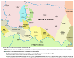
- District of Velika Kikinda
-
District of Velika Kikinda
Великокикиндски привилеговани диштрикт
Velikokikindski privilegovani dištrikt
Privilegierten Bezirk Gross Kikinda
Regio-privilegiatus Districtus Magnokikindiensis
Nagykikindai kerületdistrict of the Habsburg Monarchy ← 
1774–1876  →
→District of Velika Kikinda (1774-1876) Capital Velika Kikinda (today Kikinda) History - Established 1774 - Disestablished 1876 Today part of Serbia The District of Velika Kikinda (Serbian: Великокикиндски привилеговани диштрикт / Velikokikindski privilegovani dištrikt; German: Privilegierten Bezirk Gross Kikinda; Latin: Regio-privilegiatus Districtus Magnokikindiensis; Hungarian: Nagykikindai kerület) was an administrative unit of the Habsburg Monarchy between 1774 and 1876. It was an autonomous area mainly inhabited by ethnic Serbs.
Contents
History
It was formed on November 12, 1774, by the decision of Habsburg Empress Maria Theresa, through the special charter, as the specific feudal governmental administrative unit with headquarters in Velika Kikinda (today Kikinda, Serbia). Inhabitants of the District had, for that period, substantial economic, and even political privileges within the Habsburg Monarchy.
Until 1778, the District of Velika Kikinda was part of the Banat of Temeswar (an separate Habsburg land), and then part of the Torontal County within the Habsburg Kingdom of Hungary. In 1848-1849 it was part of autonomous Serbian Vojvodina, and from 1849 to 1860 it was part of the Voivodeship of Serbia and Banat of Temeschwar, an separate Austrian crown land. After abolishment of the voivodeship in 1860, territory of the District of Velika Kikinda was again included into Torontal County.
History of Vojvodina 
This article is part of a seriesAncient times Pannonia Lower Pannonia Pannonia Secunda Diocese of Pannonia Prefecture of Illyricum Medieval times Gepid Kingdom Byzantine Pannonia Domain of Kuber Domain of župan Butaul Voivodeship of Salan Voivodeship of Glad Voivodeship of Ahtum Voivodeship of Sermon Theme Sirmium Kingdom of Syrmia of Stefan Dragutin Upper Syrmia of Ugrin Csák Empire of Jovan Nenad Voivodeship of Syrmia of Radoslav Čelnik Modern times Eyalet of Temeşvar Sanjak of Syrmia Sanjak of Segedin Banate of Lugos and Karansebes Banat of Temeswar District of Potisje District of Velika Kikinda Serbian Vojvodina Voivodeship of Serbia and Banat of Temeschwar Bács-Bodrog County Syrmia County Torontál County Temes County Banat Republic Banat, Bačka and Baranja Danube Banovina Banat (1941–1944) Autonomous Province of Vojvodina (1945-1963) Socialist Autonomous Province of Vojvodina (1963-1990) Autonomous Province of Vojvodina
Vojvodina Portal
The District functioned, with some interruptions, until 1876 when it was abolished, and its territory was allocated both organizationally and administratively to the direct authority of the Torontal County with the headquarters in Veliki Bečkerek (today Zrenjanin), which covered most of the territory of the present-day Serbian Banat.
Places
Besides Velika Kikinda, the district included another nine settlements of the Serb border military establishments in North and Central Banat:
- Srpski Krstur
- Jozefovo (today part of Novi Kneževac)
- Mokrin
- Karlovo (today part of Novo Miloševo)
- Bašaid
- Vranjevo (today part of Novi Bečej)
- Melenci
- Kumane
- Taraš
References
- Jovan M. Pejin, Iz prošlosti Kikinde, Kikinda, 2000.
- Dr Dušan J. Popović, Srbi u Vojvodini, knjiga 2, Novi Sad, 1990.
See also
Categories:- Kikinda
- History of Banat
- History of Vojvodina
- History of Serbia
Wikimedia Foundation. 2010.

