- Chellaston
-
Coordinates: 52°52′01″N 1°26′18″W / 52.86705°N 1.43844°W
Chellaston 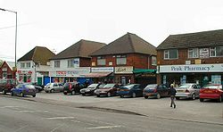
The shops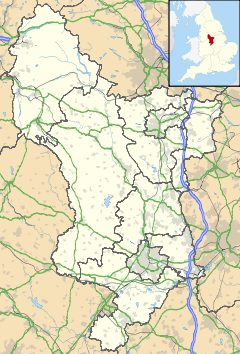
 Chellaston
Chellaston shown within DerbyshireOS grid reference SK379301 District Derby Shire county Derbyshire Region East Midlands Country England Sovereign state United Kingdom Post town DERBY Postcode district DE73 Dialling code 01332 Police Derbyshire Fire Derbyshire Ambulance East Midlands EU Parliament East Midlands UK Parliament Derby South[1] List of places: UK • England • Derbyshire Chellaston is a suburb of the City of Derby, which is in the East Midlands in England in the United Kingdom. It is on a natural hill, and has recently expanded due to several new housing estates.
The suburb lies about five miles south of Derby city centre, and is the southern-most part of the city. It borders Shelton Lock to the north and South Derbyshire to the south.
Contents
History
An early mention of Chellaston is thought to be a reference to Ceolarde's hill. This is mentioned in a 1009 charter when nearby land was given to Morcar by Ethelred the Unready. Historically, Chellaston has been part of the Hundred of Repton and Gresley.[2]
Chellaston was a separate village and was worth three shillings when the king gave it to Henry de Ferrers in the eleventh century.[2] It is mentioned as "Celerdestune" in the Domesday Book.[3]
Population of Chellaston[3][4] Year Pop. 1676 ~140 1829 ~400 1835 352 1841 461 1857 499 1871 565 1881 498 1891 497 1911 795 1921 820 Throughout the centuries, Chellaston grew slowly. By 1676, the village had grown to a population of around 140, and there were still only 42 houses in Chellaston in 1789.[3] There may have been up to two manor houses in Chellaston, but these residences were abandoned sometime around the seventeenth century. One of them is thought to have been located at the end of the present-day Manor Road.[3]
It is rumoured that Robin Hood was born at a manor house in Chellaston. This claim is mentioned in several directories and gazetteers published in the nineteenth century, but there is no evidence to substantiate this legend.[3][4] Although, Philip Marc who was the local sheriff at the time of Robin's legend had real associations with Chellaston.[5]
Chellaston's was once one of the largest producers of mined alabaster in the United Kingdom which was used to produce Nottingham Alabaster.[6] By the end of the eighteenth century, Chellaston was exporting its poor grades of alabaster as gypsum and it was transported via the local canals for markets in Derby and The Potteries. It was even used by Josiah Wedgwood for plaster moulds to shape his pottery.[7] The remains of Chellaston's pits can be found at the bottom of Pit Close Lane and Woodgate Drive, and the site is now popular with BMX bikers and teenagers.
Chellaston grew substantially between 1880 and 1950, with a number of areas being developed for housing. These developments included housing around Glenwood Road, Station Road, and North of Sutton Avenue.[8] Post 1950, the village grew even more. Houses were built in the Springfield Road and St Peter's Road areas, along with others.[8] By the 1990s, extensive housing complexes had emerged — most notably on Sutton Avenue, Maple Drive, and Parkway.
As of 2009, Chellaston has become a large Derby suburb; much larger than the original village. Two distinct housing estates to the east and west of the centre have been built. The eastern estate can be found on Snelsmoor Lane, and the west estate sprawls in an arc from the Bonnie Prince public house on Swarkestone Road to the bottom of Sinfin Moor Lane and Baltimore Bridge.
Facilities
 The Corner Pin public house
 The Lawns Hotel
Chellaston has a Co-operative supermarket on the corner of High Street and Derby Road. The Post Office is located on Derby Road near Station Road, next to Chellaston Garage (a small car repair business) and a Cantonese takeaway - Ming's Court (which used to be a petrol filling station) A Tesco Express was housed on the site next to the garage until April 2011, when it moved to a new premises at the former Red Lion public house.
There are four schools; Chellaston Infant School[9] on School Lane, Chellaston Junior School[10] on Maple Drive, Homefields Primary School[11] on Parkway and Chellaston School (senior school and 6th form college)[12] on Swarkestone Road. Chellaston School's catchment area includes the nearby villages of Melbourne, Aston-on-Trent, Ticknall, Barrow upon Trent and Weston-on-Trent.[13]
Chellaston has six pubs, including the bars at the Lawns Hotel, Chellaston Bowls Club and the British Legion on High Street. The bowls club can be traced back to 1905.[14] The others are: the Corner Pin, the Rose and Crown, and The Bonnie Prince. The Red Lion pub on Derby Road closed in late 2007. Before being converted into a public house, The Bonnie Prince used to be a grand private residence named Home Lea, home to the Osbourne family in 1901.[15][16]
Chellaston Park on Snelsmoor Lane includes a children's playground, football pitches, a cricket pitch and changing facilities. There is also a children's playground next to the Chellaston Community Centre, which is situated on Barley Croft, off High Street. In the late 2000s, a local public library was built between the community centre and the Co-operative supermarket.[17]
The 25 acre (11 ha) site of the former Chellaston Brickworks is now a designated Local Nature Reserve. [18]
Politics
Chellaston formerly lay within the South Derbyshire parliamentary constituency, but moved to Derby South following the electoral boundaries review of 2007.[19] In local council elections, Chellaston is part of the Chellaston ward.[20]
Places of worship
There are three churches in Chellaston. The sky-dominating St. Peter's Church (Church of England) on St. Peter's Road, the Methodist Church on High Street and St. Ralph Sherwin Church Catholic on Swarkestone Road next to Chellaston School. The three churches have a signed an ecumenical covenant together, and hold a joint service every month.[21] There also used to be a Baptist church in Chellaston near Pear Tree cottage on Derby Road.
The Carnival
 The site of the Chellaston Carnival
Chellaston has intermittently hosted an annual summer carnival complete with floats. Floats were contributed by local groups such as the Scouts and Guides, churches of all denominations, and Chellaston Junior School. The carnival usually takes place on the recreation ground which is located next to the community centre on Barley Croft.
Infrastructure
The main road through Chellaston is Derby Road A514, which becomes Swarkestone Road at the crossroads with High Street.[22] Approximately 1000 new homes have been built to the west of Chellaston, close to the route of the disused and in-filled Derby Canal.[23]
Formerly, the suburb had its own railway station (situated at the bottom of Station Road), but little trace of the site exists today. The station's full name was Chellaston and Swarkestone. The main public transport link is the bus service, which journeys either side of Chellaston as far as Derby and Swadlincote.[24]
Notable people
The following notable people came from Chellaston:
- Paul Aldred (former Derbyshire cricketer)[25]
- JTBD Platts (former Derbyshire cricketer)[26]
- Frederick Forman (former Derbyshire cricketer[27]
- Georgia Groome (actress that has starred in Angus, Thongs and Perfect Snogging — a member of Chellaston Players theatre group)[28]
The Chellaston Beauty tulip
 The Chellaston Beauty tulip
Chellaston Beauty is a tulip with a white base and variegated tips in near black. The flower was developed in the early 1850s.[29] Illustrated by Andrew Jet & Lance, and printed by C. Chabot.[30]
Gallery
-

Saint Peter's Church
-

View from Sinfin Moor Lane bridge
-

Chellaston School
-

Derby Road milestone
-

Approaching Chellaston from South Derbyshire
-

The Saint Ralph Sherwin Catholic Church
-

Chellaston Methodist Church
-

The Bonnie Prince public house
-

Swarkestone Road (A514)
-

Cantonese takeaway, garage, and Post Office on Derby Road (A514)
References
- ^ "Ordnance Survey Election Maps website". Ordnance Survey. http://www.election-maps.co.uk.
- ^ Domesday Book: A Complete Translation. London: Penguin, 2003. ISBN 0-14-143994-7 p.748-9
- ^ a b c d e Young, J. A. (1983). An Introduction to the History of Chellaston and its Parish Church. Chellaston, Derby: Chellaston History Group. p. 1.
- ^ a b "Chellaston, St Peter:Parish Descriptions & Trade Directory Extracts". http://rootsweb.ancestry.com. http://freepages.genealogy.rootsweb.ancestry.com/~brett/chellaston/chellaston_trade.htm#White%201857. Retrieved January 22, 2009.
- ^ Memoirs Illustrative of the History and Antiquities of the County and City of York, Communicated to the Annual Meeting of the Archaeological Institute of Great Britain and Ireland, York, July, 1816, p126, with a General Report of the Proceedings of the Meeting, and Catalogue of the Museum Formed on that Occasion By Royal Archaeological Institute of Great Britain and Ireland, Royal Archaeological Institute of Great Britain and Ireland, accessed 16 September 2008
- ^ "Discover Derby: Chellaston". www.derbyshire-peakdistrict.co.uk. http://www.derbyshire-peakdistrict.co.uk/derbychellaston.htm. Retrieved January 22, 2009.
- ^ Young, J. A. (1983). An Introduction to the History of Chellaston and its Parish Church. Chellaston, Derby: Chellaston History Group. p. 3.
- ^ a b Hilliard, Audrey and Bob. Commerce and Industry in Chellaston — 1800 to Present Day. Chellaston, Derby: Chellaston History Group. p. 11.
- ^ "Chellaston Infant School". Chellaston Infant School. http://chellastoni.co.uk/index.htm.
- ^ "Chellaston Junior School - Homepage". Chellaston Junior School. http://www.cjs.derby.sch.uk/index.html.
- ^ "Homefields Primary School". Homefields Primary School. http://homefieldsi.co.uk/.
- ^ "Welcome to Chellaston School". Chellaston School. http://www.chellaston.derby.sch.uk/.
- ^ "School Adjudicator – Chellaston School". Office of the Schools Adjudicator. http://www.schoolsadjudicator.gov.uk/upload/ADA000930%20Chellaston.doc.
- ^ "Chellaston: The History of Chellaston". BygoneDerbyshire.co.uk. http://bygonederbyshire.co.uk/articles/The_history_of_Chellaston. Retrieved January 22, 2009.
- ^ Chellaston History Group (2005). Chellaston - Bob's Collection.
- ^ "Chellaston 1901 Census Transcript". Chellaston History Group. http://freepages.genealogy.rootsweb.ancestry.com/~brett/chellaston/chellaston_1901.htm.
- ^ "Library plans reach new chapter thanks to £2m lottery help". Derby Evening Telegraph. http://www.thisisderbyshire.co.uk/news/Library-plans-reach-new-chapter-thanks-2m-lottery-helparticle-495437-details/article.html.
- ^ "Local Nature Reserves". Natural England. http://www.lnr.naturalengland.org.uk/Special/lnr/lnr_details.asp?C=0&N=Chellaston&ID=909. Retrieved 1 February 2011.
- ^ "Ordnance Survey Election Maps website". Ordnance Survey. http://www.election-maps.co.uk. Retrieved January 29, 2009.
- ^ "Election 2008 - Results". Derby City Council. http://www.derby.gov.uk/CouncilGovernmentDemocracy/Elections/election08_results.htm. Retrieved January 29, 2009.
- ^ "St Peter's Church, Chellaston, Derby, Derbyshire, England". www.derbycity.com. http://www.derbycity.com/derby2/chell.html. Retrieved January 22, 2009.[dead link]
- ^ Google Maps (2009). Chellaston (Map). http://maps.google.co.uk/maps?f=q&source=s_q&hl=en&geocode=&q=chellaston&sll=53.800651,-4.064941&sspn=13.596707,36.5625&ie=UTF8&ll=52.86843,-1.437728&spn=0.006774,0.017853&z=16. Retrieved 2009-01-22.
- ^ Google Maps (2009). Chellaston (Map). http://maps.google.co.uk/maps?f=q&source=s_q&hl=en&geocode=&q=chellaston&sll=53.800651,-4.064941&sspn=13.596707,36.5625&ie=UTF8&ll=52.873456,-1.450528&spn=0.003387,0.008926&t=h&z=17. Retrieved 2009-01-22.
- ^ "Derby City Network Map". Derby City Council. http://www.derby.gov.uk/NR/rdonlyres/EE3880CD-9B05-49D3-AF48-05BB6589386A/0/DerbyCityNetworkMap.pdf. Retrieved January 22, 2009.
- ^ Paul Aldred at CricketArchive.com
- ^ John Platts at CricketArchive.com
- ^ Frederick Forman at CricketArchive.com
- ^ Facebook:Georgina Groome
- ^ The Florist and Garden Miscellany, 1851
- ^ [1] The Journal of Horticulture, Cottage Gardener and Home Farmer, 1881
External links
- St Peter's Church Chellaston website
- Geotagged photo album of Chellaston & Shelton Lock
- Chellaston Residents' Association
- Chellaston Scouts and Guides
Suburbs of Derby, Derbyshire, England Allestree · Allenton · Alvaston · Boulton · California · Chaddesden · Chellaston · Darley Abbey · Heatherton Village · Litchurch · Little Chester · Littleover · Mackworth · Markeaton · Mickleover · New Zealand · Normanton · Oakwood · Osmaston · Pear Tree · Rose Hill · Shelton Lock · Sinfin · Spondon · Sunny Hill · West End · WilmortonCategories:- Districts of Derby


Wikimedia Foundation. 2010.