- Barcelona Metro
-
Barcelona Metro 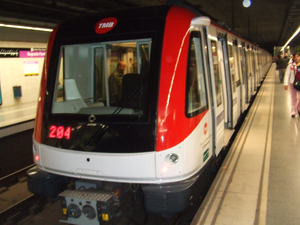
Info Locale Barcelona, Catalonia Transit type Rapid transit Number of lines 11 Number of stations 165 (List)[citation needed] Operation Began operation 1924 Operator(s) Transports Metropolitans de Barcelona and Ferrocarrils de la Generalitat de Catalunya Technical  Can Peixauet.
 Plaça de Catalunya station(L1)
 Universitat station(L1)
 Gavarra station(L5)
 Ticket vending machines, Sants Estació station.
The Barcelona Metro (Catalan and Spanish: Metro de Barcelona, Catalan: [ˈmɛtɾu ðə βərsəˈɫonə], Spanish: [ˈmetɾo ðe βarθeˈlona]), part of the public transportation system of Barcelona, Catalonia, is an extensive network of electrified railways that run underground in central Barcelona and above ground into the city's suburbs. Since July 31, 2010, Barcelona Metro system consists of 11 lines with 165 stations and 125 km in total. In 2002 ATM announced that two additional lines would built in the near future, L12 and L13.[3] There have been 3 driverless lines since 2009: Line 11, Line 9 and Line 10, in chronological order.
Contents
History
The Barcelona Metro was founded in 1924 with the construction of the Gran Metro between Lesseps and the Plaça de Catalunya, part of the modern Line 3. Two years later the Metro Transversal (now part of Line 1) was built between the Plaça de Catalunya and la Bordeta to link the city centre with the Plaça d'Espanya and Montjuïc, the site of the 1929 Universal Exhibition.
Today the network consists of ten lines managed by 2 different operators: Transports Metropolitans de Barcelona (TMB), which manages the major underground lines; and Ferrocarrils de la Generalitat de Catalunya (FGC, or Catalan Government Railways), which manages three integrated commuter lines running out into the extended metropolitan area. Fares are integrated into Autoritat del Transport Metropolità, a city-wide system that also includes local and regional buses and some regional train services. 98% of its railway tracks are subsurface.
Layout
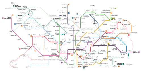 Network map
The metro network proper, operated by TMB, consists of eight lines, numbered L1 to L5 and L9 to L11, and distinguished on network maps by different colours. FGC lines are numbered L6, L7 and L8. None of the Barcelona Metro lines have a name of their own but are generally referred to by their colour or by the number and the names of their termini. The Funicular de Montjuïc, a funicular railway, is fare-integrated and listed on maps as part of the metro network, being connected directly to the metro at Paral·lel station. The lines run as follows:
Line Number Termini Operator Current Length Approved Length Current Stations Approved Stations Year of Opening 
Hospital de Bellvitge–Fondo TMB 20.700 km 29.758 km 29 38 1929 
Paral·lel–Badalona Pompeu Fabra TMB 13.700 km 18.466 km 18 34 1959 
Zona Universitària–Trinitat Nova TMB 18.400 km 20.024 km 26 36 1924 
Trinitat Nova–La Pau TMB 16.700 km 18.916 km 22 26 1926 
Cornellà Centre–Vall d'Hebron TMB 18.900 km 19.168 km 26 27 1959 
Pl. Catalunya–Reina Elisenda FGC 5.384 km 8.198 km 9 12 1863 
Pl. Catalunya–Av. Tibidabo FGC 4.634 km 4.634 km 7 7 1954 
Pl. Espanya–Molí Nou-Ciutat Cooperativa FGC 11.266 km 11.266 km 11 11 1983 
La Sagrera–Can Zam TMB 3.9 km 47.9 km 8 52 2009 
La Sagrera–Gorg TMB 6 2010 
Trinitat Nova–Can Cuiàs TMB 2.109 km 5 2003 
Parc de Montjuïc–Paral·lel TMB 0.758 km 2 1928 In addition to those, Renfe and FGC trains and the increasingly important Trambaix and Trambesòs routes and stations are displayed on most recent maps, including the info maps in the metro stations, all in a single variety of dark green.
L9 and L10
 Detalls of the capacity of trains.
Construction work is taking place currently on L9/L10, which will run from Badalona and Santa Coloma to the Zona Franca district and El Prat International Airport. The lines, which share a central section between Bon Pastor and Torrassa (L1), will be one of the longest automated metro lines in Europe, at 47.8 kilometres (29.7 mi), and will have 55 stations. As of June 2010[update], eleven stations are open. The project was approved in 2000[4] but has been challenged by some technical difficulties and some of their sections are pending further geological analysis.
Proposed lines
Main article: List of proposed Barcelona Metro linesLines L12 and L13 are two current planned additions to the network.
L12 R3
A version of the project for this line, which has been recently given the name of R3, would connect some of the urban area municipalities in Baix Llobregat, such as Esplugues de Llobregat, Sant Joan Despí or Sant Just Desvern, more efficiently than the original idea, bringing them closer to the capital by optimising connections with the bus, tram and train systems. It is due to be completed in 2015 with a budget of close to €870 million.
L13
This line would become, along with L11, one of the two underground light-rail lines fully integrated into the network. As with L11, the intention is to provide access to a hilly area of the metropolitan area: the hospital in Can Ruti in Badalona. The original project includes only three stations (which may not preclude expansion):
- Morera
- Canyet
- Can Ruti
New FGC line
A new Ferrocarrils de la Generalitat (FGC) urban line was proposed in late 2010. If completed, it would run from the new Poblenou developments to the Autonomous University of Barcelona (UAB), in Cerdanyola del Vallès through La Sagrera and the district of Horta-Guinardó. This line doesn't have a number or name yet.[5][6][7]
Past projects
Besides the current projects above mentioned, from the 1960s onwards some projects were put forward. Among these were a service numbered line VI (following the Roman numeral convention of the network at the time) and a 1980s project for a line crossing Avinguda Diagonal from north-west to south-east, the Diagonal line.[8]
Cards and pricing
In addition to the one way ticket (€1.40 as of September 2010[update][9] there are a number of other tickets and cards. All of the Autoritat del Transport Metropolità (ATM) transport cards are valid and can be used in the Barcelona Metro. These are:
- T10
- T50/30–50 journeys made in 30 consecutive days from the first use
- T Familiar (70/30)
- T Mes
- T Trimestre
- T Dia
- T Jove
All of the metro stations are within fare zone 1. Tariffs (as of 2010[10][11]), including all zones, are the following:
T 10 T Jove T 50/30 T Mes T Dia T Trimestre T Familiar (70/30) T 12 for children Fare zone 1 €7.95 €115.00 €32.40 €49.30 €6.00 €135.50 €46.75 €35.00 Fare zone 2 €15.85 €166.50 €54.35 €71.10 €9.40 €196.50 €65.85 Fare zone 3 €21.60 €223.50 €76.30 €96.10 €11.85 €265.50 €90.35 Fare zone 4 €27.75 €268.50 €94.90 €114.00 €13.35 €316.00 €110.50 Fare zone 5 €31.90 €305.50 €112.00 €131.00 €15.15 €360.00 €127.00 Fare zone 6 €33.90 €317.00 €124.50 €140.00 €16.95 €373.00 €137.00 Stations
 Elevators in Llefià station.
 LlefiàMain article: List of Barcelona metro stations
As of mid 2007, there are currently 150 operational stations in the Barcelona Metro, served by the 9 lines in current use, which will increase to 209 when lines L9 and L10 are finally completed. The average distance between stations is 650 metres.
An overwhelming majority of stations in the network lack related buildings or structures aboveground, as opposed to other subway networks as the London Underground, mostly consisting of an access with stairs, escalators and sometimes an elevator. The official TMB metro indicator, a red rhombus with a M inside, remains unused by FGC lines, which use their company logo and a different rhombus-shaped logo inside stations. Below ground their decoration is remarkably sober, with the exception of a few stations.
Disused stations
Main article: Disused Barcelona metro stationsA number of stations in the network have been closed, were never inaugurated, or a have been moved to a nearby location. See the main article for more details.
Accessibility
Accessibility for wheelchairs and for parents with pushchairs is being improved but the metro system is not yet fully accessible. A project of improvements is gradually adding more lifts from street level to ticket office level and then from ticket office level to the platforms, though many stations remain without access. See Transports Metropolitans de Barcelona for more information on which stations are currently accessible.
Transportation in the Metropolitan Area of Barcelona
The Barcelona Metro is part of a larger transportation network, regulated and fare-integrated by Autoritat del Transport Metropolità. See: Central ATM network chart, General ATM network chart.
Among these services, there are two large systems which operate both inside and outside the city limits of Barcelona: the commuter train lines operated by Renfe, amalgamated in the Rodalies Barcelona, or Ferrocarrils de la Generalitat de Catalunya lines which start in the metro lines the company operates (L6, L7 and L8 and which become a fully-fledged railway system which serves most of the metropolitan area: list of FGC lines. FGC is developing Sabadell Metro and Terrassa Metro as subway extensions of its network in the large cities of Sabadell and Terrassa respectively.
See also
Barcelona Metro topics
- List of Barcelona metro stations
- Disused Barcelona metro stations
- Autoritat del Transport Metropolità
- Spanish solution, also known as Barcelona solution
Rapid transit in Barcelona
- Transport in Barcelona
- List of railway stations in Barcelona
- RENFE and FGC-operated Rodalies Barcelona
- List of Rodalies Barcelona railway stations
- FGC suburban lines
- Trambaix and Trambesòs
- Tramvia blau
- List of tram stations in Barcelona
- Funicular de Montjuïc
- Funicular de Vallvidrera
Other metro systems in Spain
- Metro Bilbao
- Madrid Metro
- Palma de Mallorca Metro
- Seville Metro
- Valencia Metro
- Málaga Metro
- List of metro systems
References
- ^ "TMB: Basic information". TMB. http://www.tmb.net/en_US/tmb/queestmb/dadesbasiques.jsp. Retrieved 1 February 2010.—length of TMB lines
- ^ "Barcelona Metro". UrbanRail.net. http://www.urbanrail.net/eu/es/bcn/barcelona.htm. Retrieved 17 July 2011.—length of FCG lines
- ^ http://people.reed.edu/~reyn/metrobcn.pdf
- ^ http://people.reed.edu/~reyn/Linia9.pdf
- ^ http://www.transport.cat/viewtopic.php?f=2&t=10699&start=0
- ^ http://www.montcada.eu/the-news/noticias-mirame/863-una-l%C3%ADnia-de-fgc-a-trav%C3%A9s-del-t%C3%BAnel-d%5C%27horta-i-el-tramvia,-entre-els-projectes-inclosos-al-pla-d%5C%27infraestructures.html
- ^ http://www.skyscrapercity.com/showthread.php?t=455671&page=405
- ^ http://www.elperiodico.com/default.asp?idpublicacio_PK=46&idioma=CAS&idnoticia_PK=564816&idseccio_PK=1022
- ^ http://www20.gencat.cat/portal/site/SalaPremsa/menuitem.342fe4355e0205d607d7ed42b0c0e1a0/?vgnextoid=f60f88c0b0549010VgnVCM1000000b0c1e0aRCRD&vgnextchannel=f60f88c0b0549010VgnVCM1000000b0c1e0aRCRD&vgnextfmt=detall&contentid=c383c143d83fd110VgnVCM1000008d0c1e0aRCRD
- ^ http://www.atm.cat/pdfs_ang/tarifari/siste.pdf
- ^ http://www.t-12.cat/Publica/T12/Obtener.aspx
External links
- Transports Metropolitans de Barcelona
- Ferrocarrils de la Generalitat de Catalunya
- Barcelona Metro
- CityMayors article on Barcelona Metro
- Barcelona rail network map
- Wefer.com
- A blog
- Barcelona metro map for wheelchair users
- The forum of the Metro de Barcelona. (Traduction in English of Google Traductor
 •
•  •
•  •
•  •
•  •
•  •
•  •
•  •
• 
Managed by FGC  •
•  •
• 
Proposed VI • Diagonal line •
Related topics Rail transport in Spain Operators AVE · RENFE · FEVE · EuskoTren · Ferrocarril de Sóller · Serveis Ferroviaris de Mallorca · Ferrocarrils de la Generalitat Valenciana · Ferrocarrils de la Generalitat de Catalunya · Acciona · COMSA Rail TransportCommuter lines Metro/Light rail Alicante · Barcelona Metro · Barcelona Tram · Bilbao Metro · Bilbao Tram · Madrid · Valencia · Málaga · Granada · Jaén · Vitoria-Gasteiz · Palma de Mallorca · Seville · Tenerife · Parla · Vélez-Málaga · Zaragoza TramCategories:- Rail transport in Spain
- Transport in the Metropolitan Area of Barcelona
- Transport in Barcelona
- Underground rapid transit in Spain
- Barcelona Metro
- Rapid transit in Spain
- Busking venues


Wikimedia Foundation. 2010.