- Jervis Bay
-
- For other uses of the term Jervis Bay, please refer to: Jervis Bay (disambiguation).
 Jervis Bay looking through the heads, with 10 Royal Australian Navy ships at anchor, Sunday 6 February 2006. Sailors were having a sports day at HMAS Creswell. Visible on the horizon are Bowen Island and Point Perpendicular.
Jervis Bay (
 /ˈdʒɑrvɨs/ or locally /ˈdʒɜːvəs/)[1] is a large bay bounded by the state of New South Wales, the Jervis Bay Territory, and a detached enclave of the Australian Capital Territory. HMAS Creswell is located between Jervis Bay Village and Greenpatch in the Jervis Bay Territory.
Contents
History
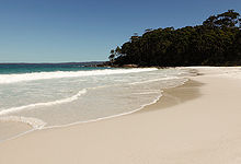
Jervis Bay is named after the British Admiral Sir John Jervis, 1st Earl of St Vincent; it was named in 1791 by Lt Richard Bowen. George Bass also entered the Bay when he surveyed the South East coast of Australia in 1797. Jervis was believed to have pronounced his name /ˈdʒɑrvɨs/, but many residents of Jervis Bay (including his descendants) pronounce it [ˈdʒɜːvəs]. Jervis Bay has been officially recorded as having the whitest sand in the world.[2]
In the late 1960s Australia's first and only nuclear power plant was proposed for the area, and a site was prepared. However, the project did not proceed.
Geography
Jervis Bay has to the south Greenpatch; Hyams Beach, and Bowen Island (Australia) in the Jervis Bay Territory. In New South Wales, it has Vincentia to the west; Callala Beach, Callala Bay and Hare Bay to the north, and the Beecroft Peninsula with bays like Perpendicular Bay. Parts of the Beecroft Peninsula and most of the northern headland of the bay (including Longnose Point) are in the Australian Capital Territory, with the exception of the Point Perpendicular lighthouse and grounds, which form an enclave of New South Wales within the ACT section of the Beecroft Peninsula. To the south of the peninsula is Point Perpendicular which is a bombing range for the Royal Australian Navy. The bay is noted for slab stones which were caused by an ancient tsunami.
Environment
Some 158 km2 of the land on both sides of the bay has been identified by BirdLife International as an Important Bird Area (IBA) because the coastal heathland supports the largest sub-population of the endangered Eastern Bristlebird, isolated from other sub-populations.[3]
Recreation
Jervis Bay is a well known recreational fishing and scuba diving destination, with tour operators departing from Huskisson and amateurs using boat ramps at bayside towns and camp sites. Popular diving sites include: The Labyrinths, Gorgonian Wall, Point Perpendicular, a Fairey Firefly aeroplane, scallop beds, Middle Ground, Ten Fathom Reef, and Bowen Island.
Jervis Bay is also known for Whale Watching, placed such that the migration, both north and south can be observed as they pass the entrance to the Bay, frequently entering the bay to rest. The majority of whales sighted at Jervis Bay are the Humpback whales, which migrate along the east coast from June to November, however other species on occasions such as Southern Right Whales, False Killer Whales, Orcas, Minke whales and on one occasion the Blue Whale are seen.
Tourism
Tourism in Jervis Bay is one of the most important avenues of income for many of the local residents, with many businesses orienting themselves toward tourism in and around Jervis Bay. Tourist information for Jervis Bay is provided by two local not-for-profit community-based volunteer association Tourism Jervis Bay and Jervis Bay Tourism Inc. The local Council managed Visitors Information Centres are located at Nowra and Ulladulla. The Jervis Bay Visitors Information Centre is at the Lady Denman Heritage Centre, within the museum buildings. It contains a wealth of knowledge for any visitor to the area.
Bordering towns (north to south)
New South Wales
- Callala Bay
- Callala Beach
- Myola
- Huskisson
- Vincentia
- Hyams Beach
Jervis Bay Territory
See also
- Jervis Bay Territory
- Australian Capital Territory
- Booderee National Park
- Beecroft Peninsula
- New South Wales Jervis Bay National Park
- HMS Jervis Bay
Notes
- ^ Macquarie Dictionary, Fourth Edition (2005). Melbourne, The Macquarie Library Pty Ltd. ISBN 1-876429-14-3
- ^ "Gazing onto the world's whitest sands". Sydney Morning Herald. Jan 1, 2006. http://www.smh.com.au/news/new-south-wales/gazing-onto-the-worlds-whitest-sands/2005/12/31/1135915721025.html. Retrieved 8 July 2011.
- ^ "IBA: Jervis Bay". Birdata. Birds Australia. http://www.birdata.com.au/iba.vm. Retrieved 2011-07-13.
References
- Scuba Divers Guide to Jervis Bay, Tom Byron
- Barker, A. 1996. What Happened When. Allen and Unwin. ISBN 1-86373-986-6
External links
Coordinates: 35°03′34″S 150°44′17″E / 35.05944°S 150.73806°E
Categories:- Jervis Bay Territory
- Bays of Australia
- Shoalhaven
- Important Bird Areas of Australia


Wikimedia Foundation. 2010.