- Lake Maninjau
-
Maninjau 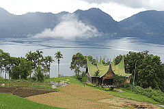
Location West Sumatra, Indonesia Coordinates 0°19′S 100°12′E / 0.317°S 100.2°ECoordinates: 0°19′S 100°12′E / 0.317°S 100.2°E Lake type Caldera lake Primary outflows Antokan River Basin countries Indonesia Max. length 16 km Max. width 7 km Surface area 99.5 km² Average depth 105 m Max. depth 165 m Water volume 10.4 km³ Shore length1 52.68 km Surface elevation 459 m 1 Shore length is not a well-defined measure. Lake Maninjau (Indonesian: Danau Maninjau, meaning overlook or observation in Minangkabau) is a caldera lake in West Sumatra, Indonesia. It is located 36 km to the west of Bukittinggi, at 0°19′S 100°12′E / 0.317°S 100.2°E.
Contents
Formation
The Maninjau caldera was formed by a volcanic eruption estimated to have occurred around 52,000 years ago.[1] Deposits from the eruption have been found in a radial distribution around Maninjau extending up to 50 km to the east, 75 km to the southeast, and west to the present coastline. The deposits are estimated to be distributed over 8500 km² and have a volume of 220–250 km³.[2] The caldera has a length of 20 km and a width of 8 km.[1]
 Fisherman on Lake Maninjau
The lake
Lake Maninjau has an area of 99.5 km², being approximately 16 km long and 7 km wide. The average depth is 105 m, with a maximum depth of 165 m. The natural outlet for excess water is the Antokan river, located on the west side of the lake. It is the only lake in Sumatra which has a natural outlet to the west coast. Since 1983 this water has been used to generate hydroelectric power for West Sumatra, generated around 68 MW at maximum load.
Most of the people who live around Lake Maninjau are ethnically Minangkabau. Villages on the shores of the lake include Maninjau and Bayur.
Maninjau is a notable tourist destination in the region due to its scenic beauty and mild climate. It is also used as a site for paragliding.
Local fishing and agriculture
Two endemic species collected from the lake for local consumption and for export to markets outside the crater are pensi, a species of small mussel, and palai rinuak, a type of small fish. One method of preparing palai rinuak is to grill a mixture of the fish along with coconut and spices, wrapped in a banana leaf.
The lake is used for aquaculture, using karamba floating net cages. The technique was introduced in 1992, and by 1997 there were over 2,000 cage units with over 600 households engaged. Each cage may have 3-4 production cycles each year. There is evidence of pollution around some karamba area.
On the edge of the lake, the landuse includes rice fields in the swamps and the lower slopes. The villages are bordered uphill by a large belt of forestlike tree gardens, which dissolves into the upper montane forest on the steepest parts of the slopes up to the ridge of the caldera.[3]
The tree gardens include three typical components:[3]
- Fruit trees including durian, jack fruit, cempedak, rambutan, langsat, golden berries and water apples.
- Timber species including Toona sinensis and Pterospermum javanicum.
- Spice trees including cinnamon, coffee, nutmeg and cardamum.
Soekarno's pantun
 Panorama of Lake Maninjau from the caldera rim
The first President of Indonesia, Soekarno, visited the area in early June 1948. A pantun he wrote about the lake reads:[4]
Jangan dimakan arai pinang,
Kalau tidak dengan sirih hijau.
Jangan datang ke Ranah Minang,
Kalau tidak singgah ke Maninjau.Do not eat arai nut,
If not with a green betel.
Do not come to Minang lands,
If you do not stop at Maninjau.See also
- List of lakes of Indonesia
References
- ^ a b Alloway, Brent V.; Agung Pribadi, John A. Westgate, Michael Bird, L. Keith Fifield, Alan Hogg, Ian Smith (30 October 2004). "Correspondence between glass-FT and 14C ages of silicic pyroclastic flow deposits sourced from Maninjau caldera, west-central Sumatra". Earth and Planetary Science Letters (Elsevier) 227 (1–2): 121. Bibcode 2004E&PSL.227..121A. doi:10.1016/j.epsl.2004.08.014.
- ^ Purbo-Hadiwidjoyo, M.M.; M.L. Sjachrudin, S. Suparka (1979). "The volcano–tectonic history of the Maninjau caldera, western Sumatra, Indonesia". Geol. Mijnb (58): Pages 193–200.
- ^ a b Michon, Genevieve (2005). Domesticating forests: how farmers manage forest resources. Center for International Forestry Research (CIFOR). ISBN 979-3361-65-4. http://www.cifor.cgiar.org/Publications/Detail?pid=447.
- ^ Burhanuddin, Jajat (2000). Ulama perempuan Indonesia. Gramedia Pustaka Utama. pp. 68–69. ISBN 9796866447.
Categories:- Lakes of Indonesia
- VEI-7 volcanoes
- Crater lakes
- West Sumatra


Wikimedia Foundation. 2010.