- Nailsworth
-
For the place in Adelaide, South Australia, see Nailsworth, South Australia.
Coordinates: 51°41′43″N 2°13′24″W / 51.6954°N 2.2234°W
Nailsworth 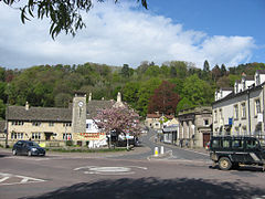
Nailsworth
 Nailsworth
Nailsworth shown within GloucestershirePopulation 5,276 (2001 Census)[1] OS grid reference ST8499 District Stroud Shire county Gloucestershire Region South West Country England Sovereign state United Kingdom Police Gloucestershire Fire Gloucestershire Ambulance Great Western EU Parliament South West England List of places: UK • England • Gloucestershire Nailsworth is a town in Gloucestershire, England, lying in one of the Stroud Valleys in the Cotswolds. It has a population of around 6,600 people (2005) and lies on the A46 road.
In ancient times it was a settlement at the confluence of the Avening Valley and the Woodchester Valley, on the Nailsworth Stream; among many notable historic buildings of medieval times in the area notable are Beverston Castle and Owlpen Manor.
In the modern era Nailsworth was a small mill town and centre for brewing. It was connected directly to the UK national rail network between 1867 and 1947 with a station that was the terminus of the Stonehouse and Nailsworth Railway.
These days Nailsworth is sleepy and tranquil, visited in the summer by walkers, and holding a farmers' market every fourth Saturday in the month. Local events like the market and the Nailsworth Festival are announced by the town crier.[citation needed]
 Egypt Mill Hotel
Over the past decade the small town centre has been reinvigorated and besides numerous restaurants and cafes now boasts a number of unusual and high-quality shops, you will find two bakers, a delicatessen with a fishmonger, two hardware stores, two butchers, craft shops, bookshops, art galleries and a gardening shop. Nailsworth is a Fairtrade Town. Nailsworth is twinned with the French village of Lèves and an exchange visit takes place every year alternating between Nailsworth and Lèves.
Forest Green Rovers are the biggest football club playing in Nailsworth and currently play in the Conference National, one level below the Football League.
Contents
St. George's Church
 The entrance to St. George's Church
The church built on the higher ground at the centre of town is St. George's and dates from 1900.[citation needed]
Christ Church and Tabernacle Church
The Baptist chapel at Shortwood was rebuilt in 1837 and, in spite of the emigration of over 80 members to Adelaide between 1838 and 1840, the adult congregation was at least 1,000 in 1851. In 1864 a dispute over a new minister led to the secession of some members who built their own chapel, opened in 1868, on Bristol Road, known as the Nailsworth Tabernacle Church. In 1910 the community rejoined the original Baptist church.
In 1967 the Shortwoood congregation united with the Forest Green Congregationalists to form a new church called Christ Church, Nailsworth. Services alternated for a few years with the Lower Forest Green Chapel, but the chapel on Newmarket Road, after modernization, became the permanent place of worship in 1972. In that year Christ Church became a member of the new United Reformed Church, although retaining its links with the Baptist Union. It had a membership of 147 in 1973.[2]
Sport and recreation
Nailsworth has a King George's Field in memorial to King George V.
The local football team, Forest Green Rovers FC play in the Football Conference.
Every spring, the town hosts the Nailsworth Festival[3] during which local artists exhibit in the windows of all the high street shops, there are numerous cultural and street events, and a free music festival, Nailstock, takes place on one of the playing fields in the town, showcasing local bands.[4]
Notable people
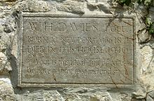
- W. H. Davies, poet
- Sue Limb, writer
- Peter Reed, Olympic rower
References
- ^ Neighbourhood Statistics
- ^ British History Inline, accessed July 16 2008
- ^ Stroud District Council
- ^ Nailstock videos hosted by the New Musical Express
External links
- Nailsworth Town Council web site
- Nailsworth Town information site and forum
- BBC archive film of Nailsworth from 1985
- Nailsworth at the Open Directory Project
Ceremonial county of Gloucestershire Unitary authorities Boroughs or districts Major settlements Berkeley | Bradley Stoke | Cheltenham | Chipping Campden | Chipping Sodbury | Cinderford | Cirencester | Coleford | Dursley | Fairford | Filton | Gloucester | Kingswood | Lechlade | Lydney | Minchinhampton | Mitcheldean | Moreton-in-Marsh | Nailsworth | Newent | Northleach | Painswick | Patchway | Stonehouse | Stow-on-the-Wold | Stroud | Tetbury | Tewkesbury | Thornbury | Winchcombe | Wotton-under-Edge | Yate
See also: List of civil parishes in GloucestershireRivers Topics History | MuseumsCategories:- Market towns in Gloucestershire
- Towns in Gloucestershire
- Stroud (district)
- Civil parishes in Gloucestershire


Wikimedia Foundation. 2010.