- Dehri
-
Dehri on Sone — city — Coordinates 24°52′N 84°11′E / 24.87°N 84.18°ECoordinates: 24°52′N 84°11′E / 24.87°N 84.18°E Country India State Bihar District(s) Rohtas Population 119,007 (2001[update]) Time zone IST (UTC+05:30) Area
• 99 metres (325 ft)
Website rohtas.nic.in/ Dehri On Sone (Hindi: देह्री अथवा डेहरी) (Traditionally called देह्री घाट, New English name: Dehri–on–Sone or डेहरी ऑन स़ोन, means on the bank of Sone River) is a city and a municipality in Rohtas district in the state of Bihar, India. It is a Sub Division under Patna Division and Headquarter of The Bihar Military Police (BMP-2) as well as The Police headquarters of the Sahabad Range. This city is also known as an industrial Town of the Rohtas district. Dehri is Well connected by road and rail and has own airbase.
Contents
Geography
Dehri, a small town in northeastern India, lies on the bank of the Sone River with an average elevation of 99 metres (324 feet). It has a Railway station on the Grand Chord railways route. Until 1984, it had three railway stations. There were two separate railway stations called Dehri–on–Sone - one for narrow gauge Dehri Rohtas Light Railway and one for the Grand Chord Line. The two railway stations had no rail link because of gauge difference and were separated by a road called Station road. The third station, Dehri City Railway station, was situated at the centre of the town on Dehri-Rohtas light Railway route. The Grand Trunk Road/शेर शाह सूरी मार्ग (NH 2) passes through the heart of the town. Dalmianagar, an industrial town is close to Dehri. Dehri is also called Dehri-On-Sone and sometimes combined as Dehri-Dalmianagar. The main occupation of the local population is agriculture - principally rice. Limestone, sand and coal is also mined.
Closure of the industrial complex
The Industrial town of Dalmianagar was founded by the industrialist Ramkrishna Dalmia, a doyens of business in 20th century India and founder of the Dalmia group. He was assisted by his younger brother Jaidayal Dalmia and son in law Sahu Shanti Prasad Jain in establishing many factories of Rohtas Industries Ltd. in Dalmianagar.
Shanti Prasad Jain took over Rohtas Industries Ltd. from his father-in-law, and under his stewardship, Dalmianagar developed into a massive industrial town from the 1940s till the 1980s with factories producing sugar, cement, paper, chemicals, vanaspati etc. employing top professionals of the country. Dehri boasted a housing colony, gardens, clubs, schools and market complexes for its employees. Rohtas Industries had their own private aircraft in those days and a small air-field at Dehri.
The prosperity of Dalmianagar started to decline in the mid 1970s as the law and order situation in this industrial town began to worsen. Workers were provoked to go on strikes for political reasons. Slowly, executives and professionals began to leave and the factories were mismanaged. By the mid 1980s factories started to shut down. Massive State Electricity Board bills remained unpaid by Rohtas Industries. There were irregularities in payment of salaries and wages to employees. By the 1990s, Dalmianagar was deserted.
A total of 12,629 workers employed in Rohtas Group of Industries Prior to its Closure in July 1984. 10,312 workers were permanent and remaining 2,317 were either contract labour or casual worker. Except for 444 employees engaged in essential services, including security services, all were thrown out of employment. Thus together with the unemployed registered with the local Employment exchange numbering 3,28,839, the total number of workers seeking employment as in June, 1987 added up to 3,41,024. The situation further worsened when thousands of people who were earlier engaged in ancillary industries in some form or the other also lost their job.
Dehri is a very old town and was prime camp on Sher Shah Suri Marg ( now Grand Trunk Road,NH#2 ). During the British empire, soldiers on its way from Kolkata to Delhi used to cross the river Sone and usually rested at a place now known as Parao meaning camp. It is also said that the name Dehri has been derived from the word "Dera" meaning basetown. It was also known for its mild climate during autumn and spring. Noted Bengali Novelist Sharat Chandra Chattopadhyay wrote his famous novel Grihadaaha in the town while he was on vacation. Dehri High School is one of the oldest secondary education centres in Bihar, established by the British for western-style education.
Demographics
According to the 2001 Indian census,[1] Dehri had a population of 119,007. Males constitute 53% of the population and females 47%. Dehri has an average literacy rate of 66%, higher than the national average of 59.5%: male literacy is 74% and, female literacy is 57%. The official language is Hindi and English. People speak in Hindi but mostly in Bhojpuri and Magahi. Some well educated people speak English. Dehri is divided in 39 wards.
Climate
Although summer temperatures may reach 43 to 48 degrees Celsius, the average summer temperature is 38 degrees. During winter the temperature is around 5 to 10 degrees Celsius. Normal rainfall is 950 mm.
Education
For primary education, the city offers many government supported and private schools, which provide education in Hindi as well as English. Schools include Model School, DAV Public School, RBS Education Foundation, Holistic Heritage Academy, Sun Beam Public School, Gurukul School Sujanpur and Dehri High School, Dillion High School, High School (Inter College) Dalmiangar, STR School etc. GEMS English School is a missionary school.
There are many girls' schools including Rama Rani Jain Balika Uchch Vidyalaya, Balika vidyalaya, Dalmianagar and one womens' college: Mahila College. For higher education, there are several UG colleges: Jawahar Lal Nehru College, Jagjeevan College, Women's College and RKS College, Baba Ganinath College, Mata Gujari Mahila College.
Hospitals
Bose Clinic Hospital, Narayan Medical College and Hospital Jamuhar, ESI Hospital, Gems Hospital, Govt. Hospital, Govind Nursing Home
Transportation and connectivity
The city is a major stations: Dehri Junction. There are well connecting trains with India's major cities. The railway bridge between Dehri-On-Sone and Sonenagar is the longest railway bridge of India having length of 3.03 K.M. of 93 span each having a length of 32.58m.[citation needed] There is a domestic airport, Suara Airport in Dehri On Sine. It is occasionally used for private planes, choppers and helicopters. Dehri is well connected with major cities of India. There is a GT Road NH 2 connecting kolkatta and Delhi. The trains which stop in Dehri On Sone include the Ranchi Rajdhani Express, Ranchi Garib Rath, Kalka mail, Purushottam Exp, Mahabodhi Exp, Kolkata Mail, Jodhpur Exp, Poorva Express, Jharkhand Swarn Jayanti Express, Puri Express, Neelanchal Express, Jalianwala Bagh Express and Chambal Exp.The local public transportation is buses, Taxi, cycle rickshaw and auto rickshaw available 24 hours.
Places of note
Indrapuri Barrage
Indrapuri Barrage is one of the longest dams in India. It is located nearly 5 km from Main Town. From it flows two major and several other smaller canals which supply the whole of western and central Bihar with water for irrigation.
 Rohtasgarh Fort
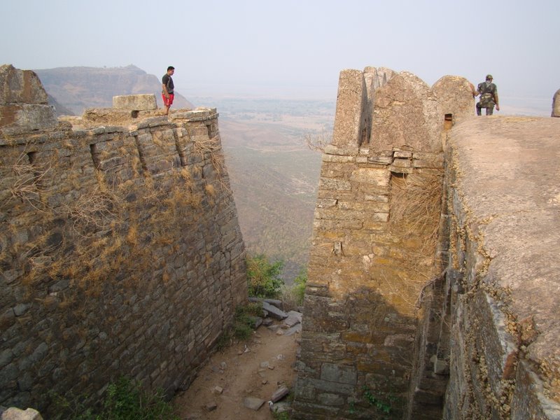
Rohtasgarh Fort
Situated at Rohtas, 40 km south of Dehri on Kaimur Range and 1500 m above sea level, It is accessible via NH 2C (National Highway 2C originating from NH 2 the Grand Trunk Road at Dehri itself), famous for Rohtasgarh Fort. Rohitashva, son of King Harishchandra founded the town of Rohtas Garh in Rohtas district, Bihar, as well as Rohtak. Punjab, originally Rohitakaul, meaning from the Kul (family) of Rohit. The Rohtas Fort is one of the most ancient forts of India. The culture of the Sone Valley is best symbolized by the Rohtasgarh Fort, which is a testimony of strength and power. Places of interest here are Hathiya Pol and Elephant Gate, The Aina Mahal, Jami Masjid and Habsh Khan's mausoleum, Ganesh Temple, The Hanging House, Rohtasan Temple and Devi Temple, Diwan-e-khas, and Diwan-e-aam. There are many waterfalls in this area, falls from top of kaimur hill towards east and joins Sone River and one can also Visit Dhurwan Kund & Gupta Dham caves, Shergarh fort on this Hill.
 Mausolée de Sher Shah Suri à Sasaram
Sasaram
Situated 17 km West of Dehri, Sasaram is accessible via Grand Trunk Road/NH 2 and by train. Sasaram has a railway station (Junction) on Howrah-New Delhi Grand Chord line of the Indian Railways, connecting Calcutta and New Delhi, headquarters of Rohtas District as well as the Sadar Subdivision Sasaram.
There are several monuments near town including the Sher Shah Suri Tomb, a hexagonally-shaped tomb built of stone, which dates back to the middle of the sixteenth century. This tomb is the second highest tomb in India. It is situated in the middle of a big tank. It is a fine specimen of the pathan architecture, and a tourist attraction. Recently Sher Shah Suri Tomb was selected as "3rd Wonder of Bihar" [2] and nominated for "7 Wonders of India." [3]
The tomb of Hasan Khan Suri, father of Sher Shah, is also located in Sasaram. His tomb is also known as Sukha Roza.
There is a temple of Goddess Tarachandi and a small inscription of Pratap Dhawal on the rock close to the temple of Chandi Devi. Hindus assemble there in large numbers to worship the goddess.
Festivals
Major festivals are Holi, Durgapuja, Dussehra, Diwali, Chitragupt Puja, Bhai dooj, Teej, Vat Savitri pooja and most important is Chhath. Chhath is grandly celebrated in the town. The whole town is decorated and wherever people from the town have migrated to, they come back to celebrate this festival. People dedicate themselves in social services like cleaning of roads, helping others during this festival.
Shopping
There are two main markets, Dehri Bazaar and Station Road Bazaar. There is no local speciality of Dehri markets. Shopping center at old GT Road Sinha Complex is under construction single largest seventh floor shopping complex in town.
Dehri is also a hub of jewellery manufacturing for local towns and cities like Garhwa, Daltonganj, Sasaram, Aurangabad and Bhabhua.
Hotels and Restaurants
De Traveller's Lodge was the oldest boarding and lodging place of the town. Sone View Hotel also operated for a long time. Amongst existing Hotels are Rimjhim Hotel is the oldest hotel, situated in Pali Road. Urvashi Hotel, Vandana Hotel, Hotel Sonebreez ( Earlier PPCL HQ ), Upkar hotel, Samrat Hotel, Aashirwad Hotel are some important hotels. Hotels situated on Station Road include Hanumani Niketan, Sufi niketan, Vivah Mandap, Agrasen Bhawan and Lagan Mandap.
Theatres
Jai hind, Apsara, Trimurti, Rohit Chitra Mandir are the important theatres of this city
Nearby Villages
Katar, Bastipur, Narayanpur, Dillian, Bhaisaha, Pahleja, Rajpur, Bank, Akori Gola, Sidhauli, Sanat Bigha, Bheria, Tar-bangala, Manikpur, Manoura, paruhar, Badiha, Ayarkotha , Darihat, Makrain, Saron, Bisrampur, Sakhra, Baligaon, Durgapur, Amari
Bank
The name of this village has been mentioned in the epic Ramayana, when Lord Ram was on his way to Buxar then while passing through this village he has to face a devil named Bankasur. And after getting rid of him he further went to Buxar, again he faced Tadika at Buxar, and this village got the name after Bankasur.This is the largest village of Rohtas District.
Katar
The unique name of the village of Katar derived its name from an incident that took place at the time of first War of Independence (1857). 'Katar' means 'a knife'. Villagers killed British police using knifes and threw their bodies in a nearby well.
Katar is nearby other villages like Narayanpur in the north, Shankarpur in south, Sone River in east and Bhaluari in west. This village has population around 1500-1600. It has two Govt. primary school located in the vicinity and one DAV public School run by private organisation.
There is one famous temple in the village which is Kaali Mandir. All the people who get married take the blessings of Maa Kaali before and after marriage. During Durga puja this temple witnesses a large gathering of people from nearby villages and also from far flung areas like Delhi, Kolkata, Chennai, Bangalore, Gujarat, Maharashtra, Uttar Pradesh and Jharkhand
Many residents work at the Navratna PSU Bokaro Steel Plant.
Sujanpur
This village is situated in Bhaishaha panchayat. It is connected to the NH-2C.In this Village Gurukul School run by Gurukul Managing Committee in Sujanpur.
References
- ^ "Census of India 2001: Data from the 2001 Census, including cities, villages and towns (Provisional)". Census Commission of India. Archived from the original on 2004-06-16. http://web.archive.org/web/20040616075334/http://www.censusindia.net/results/town.php?stad=A&state5=999. Retrieved 2008-11-01.
- ^ (http://www.youtube.com/watch?v=h9-jRihC60o, http://www.youtube.com/watch?v=A6_xquEguAk)
- ^ (http://www.youtube.com/watch?v=UcJqKNBcNjg&feature=player_embedded)
Cities and towns in Patna Division Bhojpur district Buxar district Kaimur district Patna district Bakhtiarpur • Barh • Bikram • Danapur • Dinapur Cantonment • Dinapur Nizamat • Fatuha • Hasanchak • Khagaul • Khusrupur • Maner • Maner Sharif • Masaurhi • Mokameh • Nadwan • Paliganj • Patna • Phulwari SharifRohtas district Nalanda district See also Patna division topicsCities and towns
in other DivisionsCategories:- Cities and towns in Rohtas district
- Son River


Wikimedia Foundation. 2010.