- Outer barrier
-
The outer barrier, also known as the Long Island and New York City barrier islands, refers to the string of barrier islands that divide the lagoons south of Long Island from the Atlantic Ocean.
These islands include Coney Island, Long Beach Barrier Island, Jones Beach Island, Fire Island and Westhampton Island. The outer barrier extends seventy-five miles 120 km along the south shore of Long Island, New York, from Rockaway Beach on the NYC/Nassau County border from Long Beach barrier Islands western edge, to Suffolk County's east end of Shinnecock Bay.
The lagoons enclosed by the barrier islands are Jamaica Bay, Brosewere Bay, Hewlett Bay, Reynolds Channel, Middle Bay, East Bay, South Oyster Bay, Great South Bay, and arms of the Great South Bay that have their own geographic names: Great Cove, Nicoll Bay, Patchogue Bay, Bellport Bay, Narrow Bay, Moriches Bay, Quantuck Bay, Tiana Bay, and Shinnecock Bay. East Rockaway Inlet, Jones Inlet, Fire Island Inlet, Moriches Inlet, and Shinnecock Inlet pierce the barrier, forming the individual sandy islands. The resort communities of Atlantic Beach, Long Beach, and Westhampton Beach; the Fire Island National Seashore, Robert Moses State Park, Jones Beach State Park, and other recreational areas are found there. The low-lying islands are subject to wave erosion, and, during storms, they are sometimes inundated and cut-through.
Contents
The Islands
Long Beach Barrier Island
Main article: Long Beach Barrier IslandLong Beach Barrier Island lies off the south shore of Long Island. The island is shared by the hamlet of Atlantic Beach to the west, the city of Long Beach and the hamlet of Lido Beach in the central part of the island, and the hamlet of Point Lookout at the eastern end of the island. (The three hamlets — Atlantic Beach, Lido Beach, and Point Lookout — are part of the town of Hempstead, New York.)
Within its section of the barrier island, the city of Long Beach spans the entire north-south width of the island, fronting on both Reynolds Channel, to the north, and the Atlantic Ocean, to the south. A drawbridge, the Long Beach Bridge, connects it to Island Park on the mainland of Long Island. To the west, the Atlantic Beach Bridge, connects the island to Lawrence on Long Island. The Loop Parkway, located to the east where Lido Beach and Point Lookout border one another, connects the island to Jones Beach.
 Long Beach Barrier Island
Jones Beach Island
Main article: Jones Beach Island Jones Beach Island
Jones Beach Island is a barrier island off the southern coast of Long Island in the U.S. state of New York. It is named for the father of Thomas Jones (historian). It is sometimes referred to as Oak Beach Island, and the former home of the infamous Oak Beach Inn. It is separated from Long Island by Great South Bay. The island straddles the county line between Nassau and Suffolk counties and includes the Census-designated place of Gilgo-Oak Beach-Captree, New York. The southern side of the island is known for its beaches that face the open Atlantic Ocean. Jones Beach State Park, on the western tip of the island is a summer recreational destination for the New York City area.
 Charter fishing boats at Captree State Park, NY.
It is accessible from Long Island on its western end by the Meadowbrook Parkway to Merrick, New York, the Loop Parkway to Long Beach, New York and the Wantagh Parkway to Wantagh, New York. Its eastern end is linked to Babylon, New York as well as to Fire Island, New York by the Robert Moses Causeway via the Great South Bay Bridge and the State Boat Channel Bridge. The Ocean Parkway connects all three causeways and runs the length of the island, while The Fire Island Inlet Bridge continues on the Robert Moses Causeway finding its way to the New York's Fire Island on the Atlantic Ocean.
Fire Island
Main article: Fire Island, New YorkFire Island is a barrier island, approximately 31 miles (50 km) long and varying between approximately 0.1 mile (160 m) to 0.25 mile (400 m) wide. Fire Island passes through southern Suffolk County, New York, and is southeast of Long Island separated from the main land by the Great South Bay in the U.S. state of New York, running approximately SW to NE. The land area is 8.687 sq. mi. (22.5 km2), and a permanent population of 491 people was reported as of the 2000 census. (There are hundreds of thousands of summertime residents, groupers and daytrippers.) The island is composed of three communities, as defined by the Census Bureau. The largest of these is Fire Island (CDP), which is unincorporated and stretches through the southern portion of the towns of Babylon, Islip, and Brookhaven.
 View of western Fire Island from the top of Fire Island Lighthouse
There are several ocean front communities such as, Davis Park and Watch Hill that are on the eastern side of the Great south bay. Fire Island has a variety of ocean front communities that can be reached by private boat, or seasonal ferry service from Long Island's mainland. Fire Island has a 2000 census population of 310 inhabitants. There are also two villages in the Islip section of the island, Saltaire (pop. 43) and Ocean Beach (pop. 138). In addition, a part of Fire Island CDP is not even on the island, but on a separate island adjacent to West Hampton Dunes.
Fire Island Inlet is an inlet on the south shore of Long Island, New York. It connects the Great South Bay with the Atlantic Ocean, passing between Robert Moses State Park (the western end of Fire Island) on the south and Oak Beach and Captree State Park (the eastern end of Jones Island) on the north. The stated land area and population figures result when this section is subtracted out.[1] The inlet is directly south of West Islip, the nearest town on the main part of Long Island.
 The Lighthouse at the Fire Island National Seashore
The inlet has evolved over the years due to natural processes, especially longshore drift. Jones Island and Fire Island at one time were connected. The Fire Island Light was at the mouth of the inlet when built in 1858, but is now six miles east of the inlet. [1]
Westhampton Island
Westhampton Island[2] is the eastern most Outer barrier island in the Town of Southampton. The barrier island was part of Fire Island until a Nor'easter in 1931 created Moriches Inlet and made Fire Island a proper island. In 1938, Shinnecock Inlet created this fourth barrier island. Cupsogue Beach County Park is located on the western end of the island.
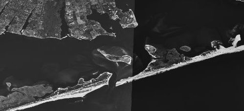
 NASA satellite map of the inlet
Moriches Inlet is an inlet connecting Moriches Bay and the Atlantic Ocean. The inlet created a geographic oddity whereby the Town of Brookhaven actually has jurisdiction on land immediately west of the village of West Hampton Dunes although Brookhaven land access to it involves a nearly 20 mile drive through Southampton.
Shinnecock Inlet is the easternmost of five major inlets [3] connecting bays to the Atlantic Ocean through the narrow 100-mile-long barrier islands that stretch from New York City to Southhampton, New York on the south shore of Long Island.
The inlet was formed by the Great Hurricane of 1938 which killed several people when it permanently broke through the island in Hampton Bays, New York.
The inlet is almost directly lined up with the Shinnecock Canal between Shinnecock Bay and the Peconic Bay and saves miles for boaters going to the open Atlantic. Consequently management has been geared to keep the inlet dredged and open. However, maintenance of the inlet has been controversial on grounds that it causes beach erosion on Fire Island.
Further information: Coastal Barrier Resources Act Great South Bay at sunset
Related
 Map of Rockaway Inlet
Rockaway Inlet is bound by Brooklyn to the North and Rockaway Peninsula to the South. It is the entrance to Jamaica Bay, and most of the inlet is within the boundary of Gateway National Recreation Area. Its entrance is marked by a light on a jetty extending southward from Breezy Point Tip.
The entrance channel extends Westward of the jetty and is marked by lighted buoys. It has a depth of about 15 feet midchannel with a shoal of only one foot.
The Ocean Parkway is a 15.59-mile (25.09 km) long state parkway that traverses the length of barrier beaches immediately south of Long Island, New York.
The Ocean Parkway begins at the southern terminus of the Meadowbrook State Parkway, intersects the south end of the Wantagh State Parkway, and ends just past the southern terminus of the Robert Moses Causeway. The parkway services a number of parks, including Jones Beach State Park and Captree State Park.
It is designated New York State Reference Route 909D, an unsigned reference route.
 Robert Moses Causeway – Robert Moses State Park, Fire Island
Robert Moses State Park (Long Island) is on the western end of Fire Island, a barrier island off the southern coast of Long Island. It is known for its 5 miles (8.0 km) stretch of splendid beaches on the open Atlantic Ocean and is a popular summer recreational destination in the New York City area. The park is accessible from Long Island by the Robert Moses Causeway across Great South Bay. This 875-acre (3.54 km2) facility is the oldest state park on Long Island.
Sources
- Outer Barrier, from The Columbia Encyclopedia, Sixth Edition.
- US Fish and Wildlife Service: Coastal Barrier Resource System
- US Fish and Wildlife Service: Legislation
References
External links
- Captree State Park
- Jones Beach State Park
- New York State Parks: Robert Moses State Park - Long Island
- Ocean Parkway article from Greater New York Roads Website
- Ocean Parkway article from NYCROADS Website
Coordinates: 40°37′N 73°16′W / 40.62°N 73.26°W
Protected Areas of New York Federal Eleanor Roosevelt • Home of Franklin D. Roosevelt • Kate Mullany House • Martin Van Buren • Saint Paul's Church • Sagamore Hill • Saratoga National Historical Park • Theodore Roosevelt Birthplace • Theodore Roosevelt Inaugural • Thomas Cole House • Vanderbilt Mansion • Women's Rights National Historical Park
African Burial Ground • Castle Clinton • Federal Hall National Memorial • Fort Stanwix • General Grant National Memorial • Governors Island • Hamilton Grange National Memorial • Statue of Liberty
Appalachian Trail • North Country National Scenic Trail
Amagansett • Conscience Point • Elizabeth A. Morton • Iroquois • Montezuma • Oyster Bay • Sayville • Seatuck • Shawangunk Grasslands • Target Rock • Wallkill River • Wertheim
State Allen H. Treman • Allegany • Amherst • Battle Island • Bayard Cutting Arboretum • Bayswater Point • Bear Mountain • Beaver Island • Beechwood • Belmont Lake • Bethpage • Betty & Wilbur Davis • Big Six Mile Creek • Blauvelt • Bonavista • Bowman Lake • Braddock Bay • Brentwood • Bristol Beach • Brookhaven • Buckhorn Island • Buffalo Harbor • Burnham Point • Buttermilk Falls • Caleb Smith • Camp Hero • Canandaigua Lake • Canoe-Picnic Point • Captree • Catharine Valley Trail • Caumsett • Cayuga Lake • Cedar Island • Cedar Point • Chenango Valley • Cherry Plain • Chimney Bluffs • Chittenango Falls • Clarence Fahnestock • Clark Reservation • Clay Pit Ponds • Cold Spring Harbor • Coles Creek • Conesus Lake • Connetquot River • Crab Island • Croil Island • Cumberland Bay • Darien Lakes • De Veaux Woods • Dean's Cove • Delta Lake • Devil's Hole • Dewolf Point • Donald J. Trump • Earl W. Brydges • Eel Weir • Emma Treadwell Thacher • Empire – Fulton Ferry • Evangola • Fahnestock • Fair Haven Beach • Fillmore Glen • Fort Niagara • Four Mile Creek • Franklin D. Roosevelt • Frenchman Island • Galop Island • Gantry Plaza • Gilbert Lake • Gilgo • Glimmerglass • Golden Hill • Goosepond Mountain • Grafton Lakes • Grass Point • Green Lakes • Hamlin Beach • Harriet Hollister Spencer • Harriman • Haverstraw Beach • Heckscher • Hempstead Lake • High Tor • Highland Lakes • Higley Flow • Hither Hills • Honeoye • Hook Mountain • Hudson Highlands • Hudson River Islands • Hudson River • Hunt's Pond • Iona Island • Irondequoit Bay • Jacques Cartier • James Baird • Jamesport • John Boyd Thacher • Jones Beach • Joseph Davis • Keewaydin • Keuka Lake • Knox Farm • Kring Point • Lake Erie • Lake Superior • Lake Taghkanic • Lakeside Beach • Letchworth • Lock 32 • Lodi Point • Long Island • Long Point - Finger Lakes • Long Point - Thousand Islands • Long Point on Lake Chautauqua • Macomb Reservation • Margaret Lewis Norrie • Mark Twain • Mary Island • Max V. Shaul • Mexico Point • Midway • Mine Kill • Minnewaska • Montauk Downs • Montauk Point • Moreau Lake • Napeague • Newtown Battlefield • Niagara Falls • Nissequogue River • Nyack Beach • Oak Orchard • Ogden Mills & Ruth Livingston Mills • Old Croton Aqueduct • Old Erie Canal • Oquaga Creek • Orient Beach • Peebles Island • Pinnacle • Pixley Falls • Point Au Roche • Reservoir • Riverbank • Robert G. Wehle • Robert H. Treman • Robert Moses - Long Island • Robert Moses - Thousand Islands • Robert V. Riddell • Roberto Clemente • Rockefeller • Rockland Lake • Sampson • Sandy Island Beach • Saratoga Lake • Saratoga Spa • Schodack Island • Schunemunk Mountain • Selkirk Shores • Seneca Lake • Shadmoor • Shaver Pond Nature Center • Silver Lake • Sonnenberg Gardens & Mansion • Southwick Beach • St. Lawrence • State Park at the Fair • Sterling Forest • Steuben Memorial • Stony Brook • Storm King • Sunken Meadow • Taconic Outdoor Education Center • Taconic - Copake Falls Area • Taconic - Rudd Pond Area • Tallman Mountain • Taughannock Falls • Theodore Roosevelt Nature Center • Thompson's Lake • Tioga • Trail View • Valley Stream • Verona Beach • Waterson Point • Watkins Glen • Wellesley Island • Westcott Beach • Whetstone Gulf • Whirlpool • Wildwood • Wilson-Tuscarora • Wonder Lake • Woodlawn Beach
Bennington Battlefield • Caumsett • Clermont • Clinton House • Crailo • Crown Point • Darwin Martin House • Fort Montgomery • Fort Ontario • Ganondagan • Grant Cottage • Herkimer Home • Hyde Hall • John Brown Farm and Gravesite • John Burroughs Memorial (Woodchuck Lodge) • John Hay Homestead • Johnson Hall • Knox's Headquarters • Lorenzo • New Windsor Cantonment • Olana • Old Croton Aqueduct • Old Erie Canal • Old Fort Niagara • Oriskany Battlefield • Philipse Manor Hall • Plantings Fields Arboretum -- Coe Hall Historic House Museum • Sackets Harbor Battlefield • Schoharie Crossing • Schuyler Mansion • Senate House • Sonnenberg Gardens & Mansion • Staatsburgh • Steuben Memorial • Stony Point Battlefield • Walt Whitman Birthplace • Washington's Headquarters
Allen Lake • Altmar • Ambler • Armlin Hill • Arnold Lake • Artic China • Ashland Pinnacle • Baker School House • Bald Mountain • Balsam • Balsam Swamp • Barbour Brook • Basswood • Basswood Pond • Bates • Battenkill • Battle Hill • Beals Pond • Bear Creek • Bear Swamp • Bearpen Mountain • Beartown • Beaver Creek • Beaver Dams • Beaver Flow • Beaver Meadow • Beebe Hill • Berlin • Big Brook • Big Buck • Birdseye Hollow • Black Creek • Blenheim • Bobell • Bombay • Bonaparte's Cave • Boutwell Hill • Boyce Hill • Brasher Falls • Brokenstraw • Brookfield Railroad • Broome • Bryant Hill • Buck Hill • Bucks Brook • Buckton • Bucktooth • Bully Hill • Bumps Creek • Burnt-Rossman Hills • Burnt Hill • Bush Hill • Cadyville • Cairo Lockwood • Calhoun Creek • California Hill • California Road • Cameron Mills • Cameron • Canacadea • Canada Creek • Canaseraga • Cascade Valley • Cat Hollow • Cattaraugus • Catherineville • Catlin • Chalres E. Baker • Charleston • Chateaugay • Chautauqua Gorge • Chenango • Cherry Valley • Chestnut Woods • Cinnamon Lake • Clapper Hollow • Clark Hill • Cliffside • Clinton • Cobb Brook • Cobb Creek State Forest • Cold Creek • Cold Spring Brook • Cole Hill • Columbia Lake • Coon Hollow • Cotton Hill • Cotrell • Coventry • Coyle Hill • Coyote Flats • Crab Hollow • Crary Mills • Cuyler Hill • Daketown • Danby • Dannemora • Decatur • Deer River • Degrasse • Delaware • Depot Hill • Deruyter • Dobbins • Dog Hollow • Donahue Woods • Downerville • Dry Run • Dunkin's Reserve • Dutch Settlement • Dutton Ridge • Earlville • East Branch Fish Creek • East Osceola • East Otto • Edwin Hollow • Edwin Mountain • Eldridge Swamp • Elkdale • English Hill • Exeter • Fall Brook • Fairfield • Farmersville • Featherstonhaugh • Fire Fall • Fish Creek • Five Streams • Flat Rock • Florence Hill • Fort Jackson • Frank E. Jadwin • Franklin • Franklin 10 • Frozen Ocean • Furnace Creek • Gas Springs • Gates Hill • Gee Brook • Genegantslet • Gillies Hill • Glenmeal • Golden Hill • Goose Egg • Gorton Lake • Gould Corners • Groundry Hill • Grafton Lakes • Granger • Grant Powell • Grantville • Greenwood • Greenwood Creek • Griggs Gulf • Hall Island • Hammond Hill • Harris Hill • Harry E Dobbins • Hartwick • Harvey Mountain • Hatch Creek • Hawkins Pond • Hemlock Ridge • Hewitt • Hickok Brook • Hickory Lake • High Flats • High Knob • High Towers • High Woods • Hill Higher • Hiltonville • Hinckley • Hogsback • Honey Hill • Hooker Mountain • Hoxie Gorge • Huckleberry Ridge • Huntersfield • Hunts Pond • Independence River • Indian Pipe • Italy Hill • Jackson Hill • Jenksville • Jersey Hill • Karr Valley Creek • Kasoag • Keeney Swamp • Kennedy • Kerryville • Ketchumville • Kettlebail • Keyserkill • Klipnocky • Klondike • Knapp Station • Lafayetteville • Lake Desolation • Lassellsville • Lebanon • Leonard Hill • Lesser Wilderness • Lincklaen • Lincoln Mountain • Line Brook • Lonesome Bay • Long Pond • Lookout • Lost Nation • Lost Valley • Ludlow Creek • Lutheranville • Lyon Brook • Macomb Reservation • Mad River • Mallet Pond • Maple Hill • Maple Valley • Marisposa • Marsh Pond • McCarthy Hill • McDonough • Meads Creek • Melondy Hill • Michigan Hill • Middle Grove • Milford • Mohawk Springs • Montrose Point • Moon Pond • Morgan Hill • Morrow Mountain • Moss Hill • Mount Hunger • Mount Pisgah • Mount Pleasant • Mount Tom • Mount Washington • Muller Hill • Murphy Hill • Nanticoke Lake • Nelson Swamp • Newfield • New Michigan • Nimham Mountain • Nine Mile Creek • North Harmony • O'Hara • Oak Ridge • Oakley Corners • Ohisa • Onjebonge • Orebud Creek • Orton Hollow • Ossian • Otselic • Otsquago • Otter Creek • Palmer's Pond • Peck Hill • Painter Hill • Panama • Papish Pond • Partridge Run • Patria • Pease Hill • Penn Mountain • Perkins Pond • Petersburg • Phillips Creek • Pigeon Hill • Pigtail Hollow • Pinckney • Pine Hill • Pine Ridge • Pitcher Springs • Pittstown • Plainfield • Plattekill • Pleasant Lake • Plum Bottom • Point Rock • Popple Pond • Potato Hill • Pulpit Rock • R. Milton Hick • Raecher • Rakph Road • Raymondville • Red Brook • Relay • Rensselaer Number 3 • Rensselaerville • Robinson Hollow • Rock City • Rock Creek • Rockwood • Roeliff Jansen Kill • Roosa Gap • Roseboom • Rural Grove • Rush Creek • Saint Lawrence • Saint Regis • Salmon River • Sand Bay • Sand Flats • Sandy Creek • Scott Patent • Sears Pond • Shawangunk • Shindagin Creek • Shindagin Hollow • Silver Hill • Skinner Hill • Skyline Drive • Slader Creek • Snow Bowl • Sodom • Sonyea • Spring Brook • South Bradford • South Hammond • South Hill • South Mountain • South Valley • Southville • Stammer Creek • Steam Mill • Steuben Hill • Stewart • Stissing Mountain • Stockton • Stone Barn • Stone Hill • Stone Store • Stoney Pond • Sugar Hill • Summer Hill • Susquehanna • Swancott Mill • Swift Hill • Taconic Hereford • Taconic Ridge • Tassell Hill • Taylor Creek • Taylor Valley • Terry Mountain • Texas Hill • Texas Hollow • Texas School House • Three Springs • Tibbetts • Titusville Mountain • Tomannex • Toothaker Creek • Tracy Creek • Tri-County • Triangle • Trout Brook • Trout Lake • Trout River • Tug Hill • Tuller Hill • Turkey Hill • Turkey Point • Turkey Ridge • Turnpike • Urbana • Ushers Road • Vandermark • Vernooykill • Wagner Farm • Wassaic • Webster Hill • Wellman • West Branch • West Hill • West Mountain • West Oscela • West Parishville • Whalen • Whaupaunaucau • Whippoorwill Corners • Whiskey Flats • White Pond • Whittacker • Wiley Brook • Windfall Creek • Winona • Wolf Brook • Wolf Lake • Woodhull • Wurtsboro Ridge • Yatesville Falls • Yellow Barn • Yellow Lake
Wild ForestsAldrich • Balsam • Black River • Blackhead • Blue Mountain • Bluestone • Cherry Ridge • Colgate Lake • Cranberry Lake • Crystal Lake • Debar Mountain • Dry Brook • Ferris Lake • Fulton Chain • Grass River • Halcott Mountain • Hammond Pond • Horseshoe • Hunter Mountain • Independence River • Jessup River • Kaaterskill • Lake George • Middle Mountain • Moose River Plains • Overlook Mountain • Phoenica • Raquette Boreal • Saranac Lakes • Sargent Ponds • Shaler Mountain • Shandaken • Sundown • Taylor Pond • Vanderwhacker Mountain • Watson East Triangle • White Hill • Wilcox Lake • Willowemoc • Windham High Peak
Other Nature ConservancyEugene and Agnes Meyer Nature Preserve • Santanoni Preserve • Arthur W. Butler Memorial Sanctuary • Indian Brook Assemblage • Marrion Yarrow Preserve • Mildred E. Grierson Memorial Wildlife Sanctuary • Mount Holly Preserve • Long Pond Preserve • Mianus River Gorge Nature Preserve • Henry Morgenthau Preserve • Mount Holly Sanctuary • Otter Creek Preserve • Uplands Farm Nature Sanctuary • Atlantic Double Dunes • Pine Neck Nature Sanctuary • Long Island Center for Conservation • Ruth Wales Sanctuary • Calverton Ponds • Accabonac Harbor • Peconic Estuary Big Woods Preserve • Mashomack Nature Preserve • Montauk Mountain Preserve • Shadmoor Preserve • Andy Warhol Visual Arts Preserve • Coon Mountain Preserve • Gadway Sandstone Pavement Barrens • Silver Lake Bog Preserve • Spring Pond Bog Preserve • Everton Falls Preserve • Clintonville Pine Barrens • O.D. von Engeln Preserve at Malloryville • El Dorado Beach Preserve • Chaumont Barrens Preserve • Freund Wildlife Sanctuary • Lewis A. Swyer Preserve • Hannacroix Ravine Preserve • Kenrose Preserve • Limestone Rise Preserve • Whitbeck Memorial Grove • Stewart Preserve • Lordsland Conservancy • Nellie Hill Preserve • Pawling Nature Reserve • Roger Perry Memorial Preserve • Thompson Pond and Stissing Mountain Preserve • Schunemunk Mountain Preserve • Sam's Point Preserve • Christman Sanctuary • Lisha Kill Natural Area • Moccasin Kill Sanctuary • Denton Sanctuary • Lower Poultney River and Saddles Preserves • West Branch Preserve
New York State Office of Parks, Recreation and Historic Preservation • New York State Department of Environmental Conservation Categories:- Geography of Long Island
- Barrier islands of New York
- Beaches of New York
- Fire Island, New York
- Robert Moses projects
- New York state parks


Wikimedia Foundation. 2010.