- Middle Atlas
-
 The Atlas Mountains
The Middle Atlas (Berber: Atlas Anammas, Arabic: الأطلس المتوسط) is part of the Atlas mountain range lying in Morocco, a mountainous country with more than 100,000 km² or 15% of its landmass rising above 2,000 metres. The Middle Atlas is the northernmost of three Atlas Mountains chains that define a large plateaued basin extending eastward into Algeria. South of the Middle Atlas and separated by the Moulouya and Um Er-Rbiâ rivers, the High Atlas stretches for 700 km with a succession of peaks among which ten reach above 4,000 metres. North of the Middle Atlas and separated by the Sebou River, the Rif mountains are an extension of the Baetic Cordillera (Baetic mountains, which include the Sierra Nevada) in the south of Spain. The Barbary Ape is native to the Middle Atlas, and chief populations occur only in restricted range in parts of Morocco and Algeria.
Snow persists in the Middle Atlas in the winter and can appear starting at 600 m above sea level. Its attractive rock coast is not very hospitable. The basin of the Sebou is not only the primary transportation route between Atlantic Morocco and Mediterranean Morocco but is an area, watered by the Middle Atlas range, that constitutes the principal agricultural region of the country.
Contents
Geography and ecology
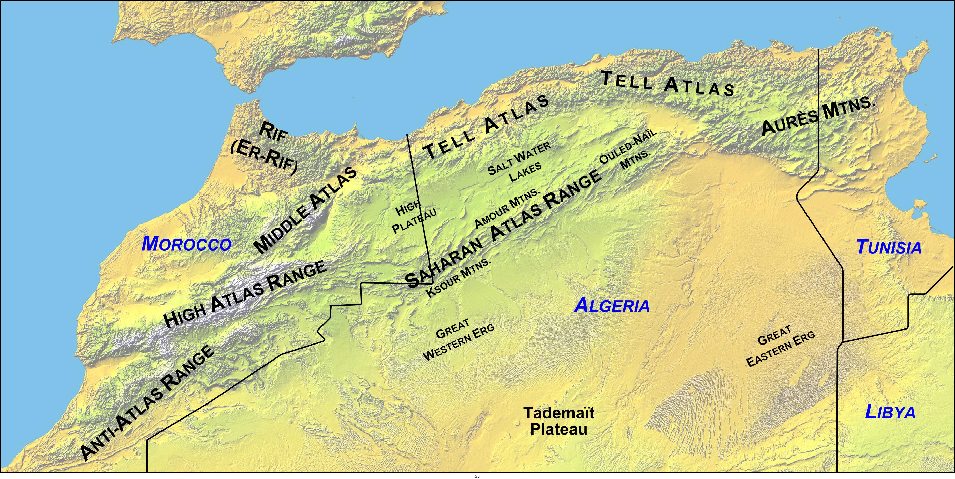
 Map showing the location of the Atlas Mountains across North Africa (topographic and political)
The Middle Atlas provinces cover 23,000 km² in area, and comprise 18% of the total mountainous surface of Morocco. The provinces of Khènifra, Ifrane, Boulmane, Sefrou, Khemisset, El Hajeb as well as parts of the provinces of Taza and of Beni Mellal lie in the Middle Atlas region. Béni Mellal on the Oum Er-Rbia River is designated "the doorway to the Middle Atlas."
The Middle Atlas is a solid mountainous mass of 350 km in length in the North-East of Morocco with a unique charm. Its biodiversity, both in fauna and flora, make Middle Atlas a significant tourist destination. The region is noted for occurrence of the endangered primate, Barbary Macaque, Macaca sylvanus; this monkey prehistorically had a much wider distribution throughout northern Morocco.[1] Wild boar and polecat are also found within the Middle Atlas Range.[2]
Its geo-mophologic structure is:
- Primarily limestone.
- Tabled rock in the west, running to elevations of 800 to 1,000 metres.
- Folded rock toward the northeast and running to elevations exceeding 3000 m, with a highest point, the Jbel Bou Naceur at 3340 m.
- Interspersed with volcanic plateaus.
Over the mountain slopes, extensive forests of cedar spread, intersected by deep valleys. Bordered by the rich Plaine du Saïs and the cities of Fes, Meknes and Beni Mellal, the mountainous reaches of the Middle Atlas are the stronghold of Berber tribes, speaking Tamazight and living at very low population densities.
 Area of cedars of Khénifra
The Middle Atlas is crossed by one of the principal access roads to the south Marocain, connecting Fes with Tafilalet. Located at the northeast of Atlas. The Middle Atlas ends in the east at Tazekka National Park[3], with a landscape replete with narrow canyons and caves. In the south of Sefrou, the forests of cedars, of Holm oak and of Cork Oak alternate with plates volcanoic stripped and small full of fish lakes. The jewel of the Middle Atlas is it Ifrane National Park, located in causse atlassic between Khenifra and Ifrane.
The Middle Atlas high points are Jbel Bou Naceur (3340 m), then Jbel Mouâsker (3277 m), in the North, and finally Jbel Bou Iblane (3172 m), which lies close to Immouzer Marmoucha.
Climate
Because of its elevation, the Middle Atlas experiences snow during the winter months and a cool climate during the summer. The town of Ifrane enjoys sufficient snow during the winter months that it provides accommodations quite rare in Africa; it is a ski resort.
Major Catchments
The Middle Atlas includes four major catchment areas:
- Le basin of Sebou: of a surface of approximately 40,000 km², discharging to the Atlantic Ocean.
- Le basin of Oum Errabiaa: extends on a surface from 35,000 km², discharging to the Atlantic Ocean.
- Le basin of Bou Regreg: cover a surface of about 10,000 km², discharging to the Atlantic Ocean.
- Le basin of Moulouya: takes its source in the Almssid region and drains both the Middle and the High Atlas, with a watershed of 74,000 km², discharging to the Mediterranean.
The Middle Atlas contributes abundant and the relatively regular flows to these rivers. Reservoirs have been developed for flood control, to improve tourism, and to create water reserves supporting the development of the arboriculture important to the agricultural industry of the region. 5759547 josh c
See also
- Mediterranean woodlands and forests
- Cèdre Gouraud Forest
- Idriss I (dam)
- Ouergha River
References
- C. Michael Hogan. 2008. Barbary Macaque: Macaca sylvanus, GlobalTwitcher.com, ed. N. Stromberg
- Marshall Cavendish Corporation. 2006. World and Its Peoples, Published by Marshall Cavendish, ISBN 0761475710, 9780761475712
Line notes
Categories:- Atlas Mountains
- Mountain ranges of Morocco


Wikimedia Foundation. 2010.