- M-89 (Michigan highway)
-
M-89

Route information Maintained by MDOT Length: 61.19 mi[1] (98.48 km) Major junctions West end: 
 I-196 / US 31 near Ganges
 M-40 in Allegan
 US 131 in Plainwell
 M-43 in Richland
 M-37 in Battle Creek
East end:  BL I-94 in Battle Creek
Location Counties: Allegan, Barry, Kalamazoo, Calhoun Highway system Michigan State Trunkline Highway System
Interstate • US • State←  M-88
M-88M-90  →
→M-89 is an east–west state highway in the US state of Michigan. It runs from near Ganges Township to Battle Creek. M-89 passes through Allegan County, Kalamazoo County, Michigan, and Calhoun County. It also briefly crosses the southwest corner of Barry County.
Contents
Route description
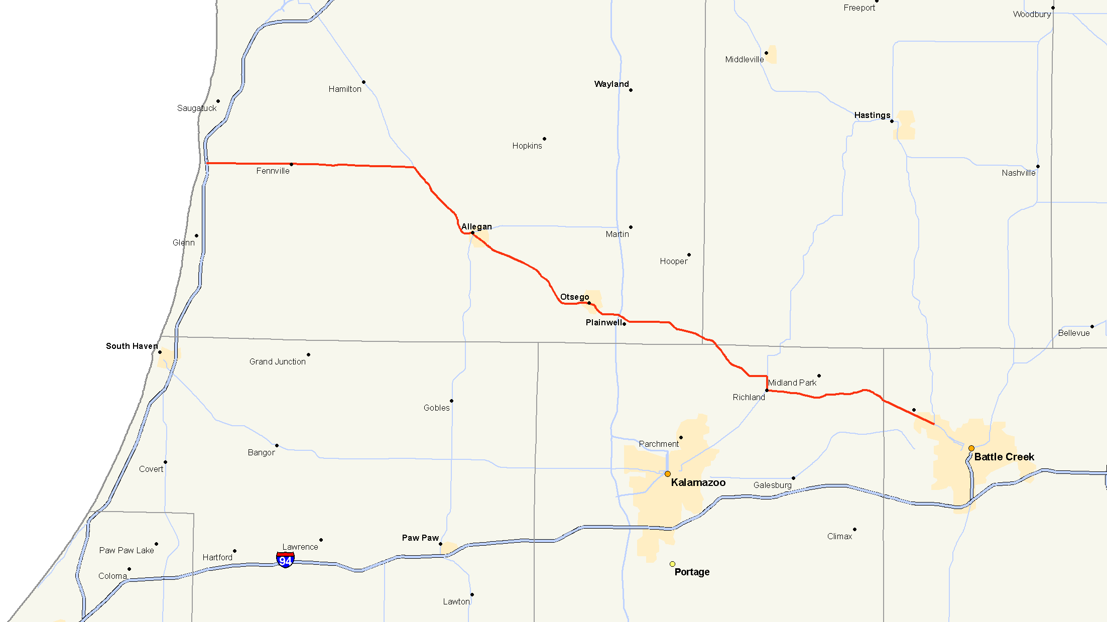
M-89 begins at an interchange with I-196 and US 131 near Ganges, just a half-mile from Lake Michigan. The route travels east from there through small communities like Fennville and passes just north of Swan Creek Marsh and crosses the Kalamazoo River about two miles (3 km) west of its intersection with M-40. From US 31 to M-40, M-89 is also known as 124th St. M-89 and M-40 run concurrently to the southeast for 6.5 miles (10.5 km) across Lake Allegan on the Kalamazoo River into Allegan. Just two blocks before M-89 splits from M-40, the concurrent route has a junction with M-222. After M-89 splits from M-40, the route continues out of Allegan to the southeast, again crossing over the Kalamazoo River.
After leaving Allegan, M-89 runs roughly parallel with the Kalamazoo River for approximately 12 miles (19 km), passing through mostly rural areas spotted with residences and agricultural fields. The route curves to the east and crosses the Kalamazoo River again just west of the city of Otsego. The route curves to the south in the city then again runs east to junction with US 131 at exit 49 on the west side of Plainwell. East of US 131, the route passes through the city of Plainwell and crosses the Kalamazoo River again before continuing into rural areas again. The route then heads the southeast on towards the village of Richland.
Just north of Richland, M-89 meets up with M-43, and the two share a brief routing together for a mile as M-43 heads southwest out of Richland while M-89 heads east, passing to the south of Gull Lake. After passing the lake, the route turns southeast towards Battle Creek.
As M-89 begins to enter the outskirts of Battle Creek it becomes known, locally, as Michigan Avenue. It passes through the neighborhoods of Level Park-Oak Park and Urbandale the first residential areas of the city. As M-89 continues towards Battle Creek it has a junction with M-37. M-89 continues on Michigan Avenue until an intersection with Washington Avenue where the route turns to the southwest where it crosses the Kalamazoo River one last time and terminates a few blocks later at Dickman Road, otherwise known as the I-94 Business Loop.[2][3]
History
The 1920 incarnation of M-89 was a much shorter relative of today's road. Its western terminus was at a junction with M-11, present day US 31 near Ganges. It traveled east to Fennville then turned south to Pearl before turning back to the east towards Allegan on an alignment that is a few miles south of the present day configuration. The route then left Allegan on present day M-222 and terminated at M-13 (Michigan highway), which is now the US 131 freeway.
In 1926, when M-40 was extended, M-89 was rerouted out of Allegan to the southeast along its present day alignment to terminate at US 131 in Plainwell. Just a few years later, the road was extended further to the southeast to Richland then east along its present day routing to end at M-96 in Augusta. In 1931, the route was realigned to run east, rather than south into Augusta, where it then met up with M-96 just inside the Calhoun County line. The road remained in this fashion for the next 20 years.
In 1952, M-89 was realigned to run east from Fennville, rather than south to Pearl, to junction with M-40 then run concurrently into Allegan. In 1963, when the I-196/US 131 freeway opens, the western terminus of M-89 is extended to meet the new freeway. A few years later, when M-96 was realigned onto a route that took it into Battle Creek, M-89 was extended southeasterly along Michigan Avenue (the old M-96) and terminated at M-37.
During the Rationalization process, in 1998, M-89 is extended to the south in Battle Creek to replace the old routing of M-37 along Michigan Avenue, it then turned south on Washington to the I-94 Business Loop where it terminated, thus bringing the route to its current alignment.[4]
Major intersections
County Location Mile[1] Destinations Notes Allegan Saugatuck Township 0.00  I-196 / US 31 / LMCT
Valley Township 14.43 M-40 northWestern end of M-40 concurrency Allegan 20.88  M-222 east
21.05 M-40 southEastern end of M-40 concurrency Plainwell 33.20 US 131Exit 49 on US 131 34.07  A-45
A-45Kalamazoo Richland Township 44.92 M-43 northNorthern end of M-43 concurrency Richland 45.92 M-43 southSouthern end of M-43 concurrency Calhoun Battle Creek 58.23 M-3761.19 BL I-941.000 mi = 1.609 km; 1.000 km = 0.621 mi
Concurrency terminus • Closed/Former • Incomplete access • UnopenedReferences
- ^ a b "MiGDL - Center for Geographic Information - Geographic Data Library". Michigan Department of Information Technology. May 2007. http://www.mcgi.state.mi.us/mgdl/?rel=thext&action=thmname&cid=14&cat=MI+Geographic+Framework+All+Roads+%28v7b%29. Retrieved February 24, 2008.
- ^ "Google Maps". Google Maps. http://maps.google.com/. Retrieved February 24, 2008.
- ^ Michigan Department of Transportation. Official 2007 Department of Transportation Map (Map) (2007 ed.). Section L8, L9, L10, M8, M9, M10.
- ^ Bessert, Christopher J.. "Michigan Highways: Highways 80 through 80". Michigan Highways. http://www.michiganhighways.org/listings/MichHwys80-89.html#M-089. Retrieved February 24, 2008.
External links
Categories:- State highways in Michigan

Wikimedia Foundation. 2010.